On Franklin Street at Beckwith Street, on the right when traveling east on Franklin Street.
Originally the site of the Market Square, Memorial Park was created with the dedication of the local cenotaph in 1924. Part of Memorial Park also consists of land (the north-eastern section) donated by the Gillies family as a result of . . . — — Map (db m234330) HM
On Franklin Street at Beckwith Street, on the right when traveling east on Franklin Street.
On June 8th, 2013, a dedication ceremony was conducted on this site following a three year restoration and expansion project of the cenotaph area. This project was completed through the joint efforts of the Town of Carleton Place, Veterans . . . — — Map (db m234332) HM
On Bridge Street at the north bank of the Mississippi River, on the left when traveling north on Bridge Street.
[Stylized bas relief of Roy Brown's epic dogfight with the Red Baron]
[Sculpture of Roy Brown looking skyward with the
Distinguished Service Cross in hand] — — Map (db m234444) HM
On Beckwith Street at Franklin Street, on the right when traveling north on Beckwith Street.
Victor in aerial combat over Baron Manfred von Richthofen, the First World War's leading fighter pilot and German national hero, Arthur Roy Brown was born at Carleton Place. In 1915 he qualified as a civilian pilot and was commissioned . . . — — Map (db m103968) HM
Built between 1895 and 1897 for a cost of $26,000, our Town Hall was designed in the Richardson Romanesque style by Toronto architect George King. It replaced the original Town Hall built in 1872 on Edmund Street. The chateau style . . . — — Map (db m234392) HM
On Mill Street just east of Bridge Street, on the left when traveling east.
Unveiled on May 17, 2019, this pebble mosaic was created by 75 members of the Carleton Place community as a tribute to sexual assault victims.
Made in collaboration with Lanark County Interval House and Red Dress Productions, this monument . . . — — Map (db m234377) HM
On Bridge Street at the Mississippi River, on the right when traveling south on Bridge Street.
Scottish born David Findlay arrived in Canada in 1858 and settled in Perth, Ontario. Finding little opportunity for working at his trade as a moulder, he left two years later for
Carleton Place. Walking the 21 miles with only $30 in . . . — — Map (db m234402) HM
On Flora Street at McRostie Street, on the right when traveling south on Flora Street.
The families of Edmond Morphy and William Moore became in 1819 the first settlers on the site of Carleton Place. About 1822 Hugh Boulton built a mill here on the Mississippi River which provided the nucleus around which a community, known as . . . — — Map (db m103985) HM
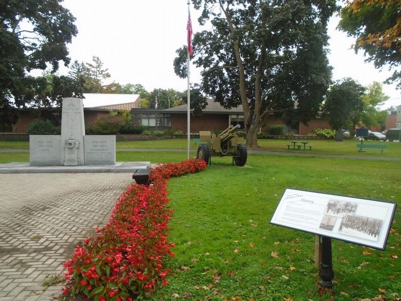
On Franklin Street at Beckwith Street, on the right when traveling east on Franklin Street.
CONFLICTS SINCE 1953
1946-1991/Cold War • 1990-1991/Gulf War • 1992-1995/Somali Civil War
1992-1995/Bosnian War • 1998-1999/Kosovo War
1999-2000/East Timor • 2001-2014/Afghanistan War
2003-2011/Iraq War • 2011/Libyan Civil War
OUR . . . — — Map (db m234334) WM
On Bridge Street at Lake Avenue, on the right when traveling west on Bridge Street.
This grand stone hotel at 7 Bridge Street was built on land originally deeded in 1824 to William Morphy, one of Carleton Place's original settlers. It was built by Napoleon Lavalee in 1872, who operated it as a hotel and a . . . — — Map (db m239904) HM
On Bridge Street just west of Albert Street, on the right when traveling west.
The first post office was established in town in 1830. That same year, the name of the community changed from Morphy's Falls to Carlton Place, and then, through a slip in typing, to Carleton Place. By 1890, the growth of the town was . . . — — Map (db m234052) HM
On Bridge Street, 0.1 kilometers south of Emily Street, on the left when traveling south.
The settlers who first received land grants within the present area of the Town of Carleton Place were four members of the family of Edmond Morphy and three members of the William Moore family. The Moore family's grant stretched from present-day . . . — — Map (db m234328) HM
On Mill Street just east of Bridge Street, on the left when traveling east.
The Town Hall Square forms the nucleus of the pioneer development along the Mississippi River and rapids. This environmentally important area, near the unique and significant stand of Hackberry Trees, has become the central part of the Town of . . . — — Map (db m234372) HM
On Mill Street just east of Bridge Street, on the left when traveling east.
The Ripple [Steamboat on Mississippi River] 1885
First Nations Harvesting of wild rice
Logging on the Mississippi
Men's War Canoe Team 1905
The Ballygiblin Riots 1824 — — Map (db m234374) HM