Marker Logo HMdb.org THE HISTORICAL
MARKER DATABASE
“Bite-Size Bits of Local, National, and Global History”


13 entries match your criteria.  


Historical Markers in Rocky Point, Prince Edward Island

 
Marker detail: Holland’s Survey / Plan d’arpentage de Holland image, Touch for more information
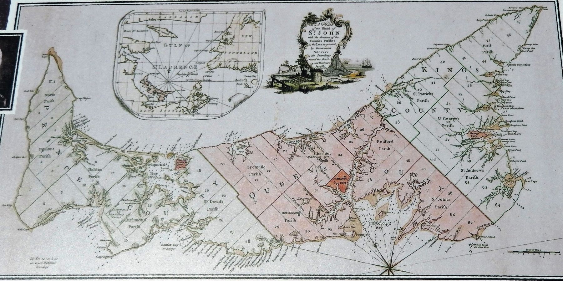
Courtesy Library and Archives Canada
Marker detail: Holland’s Survey / Plan d’arpentage de Holland
1 Prince Edward Island, Queens County, Rocky Point — A Great Survey / Un Arpentage de Taille
Near Hache Gallant Drive, 1.2 kilometers east of Prince Edward Island Route 19, on the left when traveling east.
2 Prince Edward Island, Queens County, Rocky Point — A Human Tragedy / Une tragédie humaineThe 1758 Deportation / La déportation de 1758
Near Hache Gallant Drive, 1.2 kilometers east of Prince Edward Island Route 19, on the left when traveling east.
3 Prince Edward Island, Queens County, Rocky Point — History All Around You / Quand l’histoire vous entoure
Near Hache Gallant Drive, 1.5 kilometers east of Prince Edward Island Route 19.
4 Prince Edward Island, Queens County, Rocky Point — Michel Haché-GallantThe Core of the Community / Le noyau de la Communauté
Near Hache Gallant Drive, 1.2 kilometers east of Prince Edward Island Route 19, on the left when traveling east.
5 Prince Edward Island, Queens County, Rocky Point — Michel Haché-Gallant et Anne Cormier
Near Hache Gallant Drive, 1.2 kilometers east of Prince Edward Island Route 19, on the left when traveling east.
6 Prince Edward Island, Queens County, Rocky Point — Place Yourself in History / Situez-vous dans l’histoire
Near Hache Gallant Drive, 1.2 kilometers east of Prince Edward Island Route 19, on the left when traveling east.
7 Prince Edward Island, Queens County, Rocky Point — Port of Entry / Port d’entrée
Near Hache Gallant Drive, 1.2 kilometers east of Prince Edward Island Route 19, on the left when traveling east.
8 Prince Edward Island, Queens County, Rocky Point — Port-la-Joye – Fort Amherst
Near Haché Gallant Drive, 1.2 kilometers east of Prince Edward Island Route 19, on the left when traveling east.
9 Prince Edward Island, Queens County, Rocky Point — Survey of Prince Edward Island / Arpentage de Ľîle-du-Prince-Édouard
On Prince Edward Island Route 19 just south of Rogers Passage Lane, on the left when traveling south.
10 Prince Edward Island, Queens County, Rocky Point — The British Period / La période britannique
Near Hache Gallant Drive, 1.2 kilometers east of Prince Edward Island Route 19, on the left when traveling east.
11 Prince Edward Island, Queens County, Rocky Point — The Deportation of the Inhabitants of Île Saint-JeanLa Déportation Des Habitants de L’île Saint-Jean
Near Haché Gallant Drive, 1.2 kilometers east of Prince Edward Island Route 19, on the left when traveling east.
12 Prince Edward Island, Queens County, Rocky Point — The Grand DérangementÎle Saint-Jean
Near Hache Gallant Drive close to Blockhouse Road, on the left when traveling east.
13 Prince Edward Island, Queens County, Rocky Point — The Mi'kmaq / Les Mi'kmaqFirst People of Prince Edward Island / Premiers habitants de l'Île-du-Prince-Édouard
Near Hache Gallant Drive, 1.2 kilometers east of Prince Edward Island Route 19, on the left when traveling east.
 
 
CeraNet Cloud Computing sponsors the Historical Marker Database.
This website earns income from purchases you make after using our links to Amazon.com. We appreciate your support.
Paid Advertisement
May. 7, 2024