Near North Pipe Spring Road, 0.3 miles north of Arizona Route 389, on the left when traveling north.
I have personally visited Pipe Spring several times and realize the desirableness of having this area established as a National Monument for the benefit of motorists traveling between Zion and Grand Canyon Parks. —Director Stephen . . . — — Map (db m149343) HM
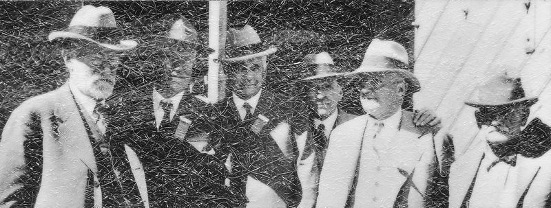
Established May 31, 1923
Through effort of Stephen T. Mather and friends
Pipe Springs
Occupied in 1863 by Dr. James M. Whitmore, who, with Robert McIntyre, was killed 4 miles S.E. Of here January 3, 1866 by Navajo and Piute . . . — — Map (db m131296) HM
Near North Pipe Spring Road, 0.3 miles north of Arizona Route 389, on the left when traveling north.
He laid the foundation of the National Park Service, defining and establishing the policies under which its areas shall be developed and conserved unimpaired for future generations. There will never come an end to the good that he has done. — — Map (db m149341) HM
Near North Pipe Spring Road, 0.3 miles north of Arizona Route 389, on the left when traveling north.
Pipe Spring National Monument is establishing a native vegetation plot, reminiscent of the grasslands of the Arizona Strip prior to the 1850s. Over-abundant shrubs (four-wing saltbush and sagebrush) were removed from the area, and native grasses and . . . — — Map (db m149366) HM
Near North Pipe Spring Road, 0.3 miles north of Arizona Route 389, on the left when traveling north.
Pipe Spring 1859 — Arrived about noon hungry, tired, and thirsty. I now treated myself to a good drink of water, took breakfast & rested myself… Plenty of feed and good water at this place. —Thales Haskell, 25-year-old Mormon . . . — — Map (db m149367) HM
Near North Pipe Spring Road, 0.3 miles north of Arizona Route 389, on the left when traveling north.
Paiute people used the dark green leaves of datura, crushed as a poultice, to treat sores and swelling. This traditional medicinal plant was chewed to reduce toothache pain, as well as induce visions. Datura is highly poisonous. Please do not touch. — — Map (db m149368) HM
Near North Pipe Spring Road, 0.3 miles north of Arizona Route 389, on the left when traveling north.
…Paiutes once lived in homes just like the Ancient Ones as they dwelled near the spring. When the Spanish came… bringing with them the slave trade, the women and children were carted off to slave markets. When the Navajos and Utes started coming . . . — — Map (db m149369) HM
Near North Pipe Spring Road, 0.3 miles north of Arizona Route 389, on the left when traveling north.
1880 — Ten years ago the desert spaces… were covered with abundant grasses. Today hardly a blade of grass is to be found within 10 miles of [Pipe] spring… Even if there had been no drought… cattle would have… destroyed the grass by cropping . . . — — Map (db m149473) HM
Near North Pipe Spring Road, 0.3 miles north of Arizona Route 389, on the left when traveling north.
A long line of juniper poles — like the one you see here — set 70 yards apart ended Pipe Spring’s isolation. From 1871 on, telegraph wire connected the ranch first to Utah and then to the outside world. By 1880 Mormon settlements from . . . — — Map (db m149370) HM
Near North Pipe Spring Road, 0.3 miles north of Arizona Route 389, on the left when traveling north.
In the fall, look for plum-sized purple fruit on these prickly pear cactus. These 'pears' are good eaten fresh. Paiute people compressed and dried the fruits into cakes for trade and winter storage. — — Map (db m149371) HM
Near North Pipe Spring Road, 0.3 miles north of Arizona Route 389, on the left when traveling north.
The answer lies buried in the white and red rocks you can see ahead. Here about 90 percent of any rain and snow is absorbed by plants or quickly evaporates. Only 10 percent of Pipe Spring’s precipitation soaks into the light-colored rock you see at . . . — — Map (db m149469) HM
Near North Pipe Spring Road, 0.3 miles north of Arizona Route 389, on the left when traveling north.
Pipe Spring, October 1870 to April 1872 — The sound of hammers striking steel drills and chisels rang out on this hillside for more than a year as the walls of Winsor Castle went up. Master stone masons Elijah and Elisha Averett were sent by . . . — — Map (db m149375) HM
Near North Pipe Spring Road, 0.3 miles north of Arizona Route 389, on the left when traveling north.
It may seem strange, but in talking with [the Paiutes] I have never been able to obtain… any ideas of what they supposed might be [their] northern and southern boundaries. Their usual reply is, “The ancients never told us about a northern . . . — — Map (db m149382) HM
Near North Pipe Spring Road, 0.3 miles north of Arizona Route 389, on the left when traveling north.
Paiute people still use Indian tea (or Mormon tea) as both a beverage and a medicine. An infusion of the gray-green spikelets can treat stomach aches, rheumatism, colds, and kidney problems. Tup' also serves as a blood tonic that improves . . . — — Map (db m149396) HM
Near North Pipe Spring Road, 0.3 miles north of Arizona Route 389, on the left when traveling north.
Two evergreens important to the Paiute people grow intermingled on this ridge top. Throughout the desert Southwest, at elevations from 4,500 to 7,500 feet above sea level, with more than 12 inches of rain a year, look for stands of pinyon and . . . — — Map (db m149397) HM
Near North Pipe Spring Road, 0.3 miles north of Arizona Route 389, on the left when traveling north.
The pale rock you see here is Navajo sandstone. This rock caps the top of the Vermilion Cliffs for more than 80 miles. Navajo sandstone also forms the high canyon walls at Zion National Park. Imagine an enormous Sahara-like desert, full of . . . — — Map (db m149385) HM
Near North Pipe Spring Road, 0.3 miles north of Arizona Route 389, on the left when traveling north.
From this ridge you are looking south over the Arizona Strip. This high plateau is cut off from the rest of Arizona by the depths of the Grand Canyon, which lies unseen over the far horizon. Only footbridges cross the Colorado River between . . . — — Map (db m149398) HM
Near North Pipe Spring Road, 0.3 miles north of Arizona Route 389, on the left when traveling north.
Baskets and cradleboards were made from the stems of the three-leaf sumac, but its tart berries bring back Paiute people's best memories. Also called lemonadeberry, the small fruits were pounded into a pulp, then squeezed. Mixed with water, the . . . — — Map (db m149399) HM
Near North Pipe Spring Road, 0.3 miles north of Arizona Route 389, on the left when traveling north.
Food, fuel, and fiber came from the yucca. Paiute people pounded the leaves to obtain fiber for rope, nets, baskets, jugs, mats, and sandals. Shampoo came from the roots. The fruit was roasted and then eaten, or made into a ball and dried for winter . . . — — Map (db m149401) HM
Near North Pipe Spring Road, 0.3 miles north of Arizona Route 389, on the left when traveling north.
Acorns of this scrub live-oak were collected for food. The acorn meats were roasted, boiled, or ground into flour. Kwi’-uv provided a slow, long-burning fuel in a region where hardwoods are scarce. Live-oak wood made tough bows. — — Map (db m149470) HM
Near North Pipe Spring Road, 0.3 miles north of Arizona Route 389, on the left when traveling north.
Paiute families watched rabbitbrush closely as summer ended. This blossom marked the time to move to high country to gather pinyon nuts, a favorite food. Portions of the root could be chewed like gum. — — Map (db m149402) HM
Near North Pipe Spring Road, 0.3 miles north of Arizona Route 389, on the left when traveling north.
Many high places you see jutting out along the Vermilion Cliffs had to be climbed by this team of federal surveyors in winter 1872–73. Explorer John Wesley Powell often camped and resupplied at Pipe Spring. From here the survey team set up . . . — — Map (db m149400) HM