Near County Road 101 (Business U.S. 169) at Sarazin Street, on the right when traveling west.
When glaciers melted, the meltwater created Lake Agassiz, which was bigger than the Great Lakes. The lake drained over the years, creating the massive River Warren. The river carved out the Minnesota River Valley and started from the bluffs by . . . — — Map (db m213089) HM
Near County Road 101 (Business U.S. 169) at Sarazin Street, on the right when traveling west.
In the late 1600s, the Mdewankanton Dakota moved from Mde Wakaŋ (Mille Lacs Lake) to along the Mnisota Wakpa, later called the Minnesota River. One planting village was located on the north side of the river in the area later called Shakopee. . . . — — Map (db m213090) HM
Near County Road 101 (Business U.S. 169) at Sarazin Street, on the right when traveling west.
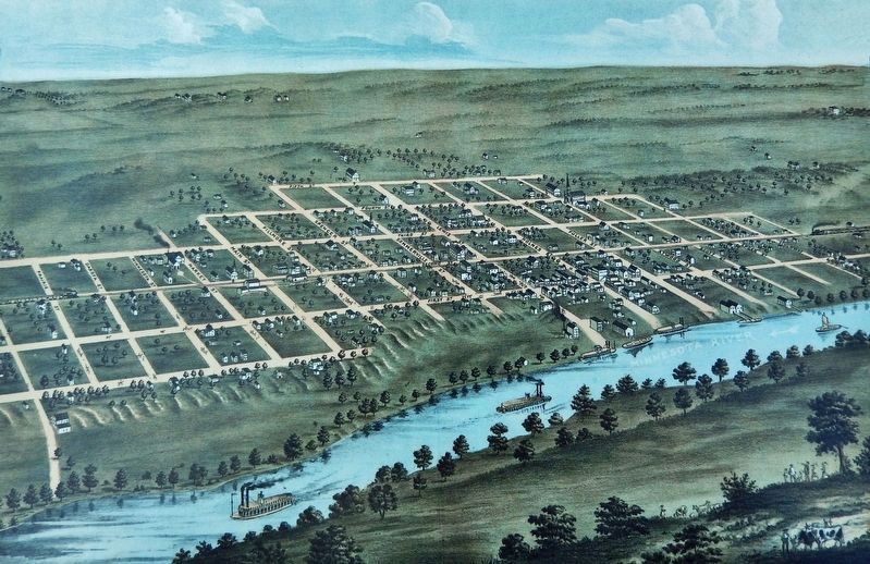
The first steamboat Argo churned the muddy waters of the Rivière Saint-Pierre (St. Peter's River) in 1842, eventually arriving at Sakpe II's village of Tíŋta Otuŋwe. On July 22, 1850, the steamboat Yankee started at the . . . — — Map (db m213095) HM
Near County Road 101 (Business U.S. 169) at Sarazin Street, on the right when traveling west.
"The power of the Dakotas had always dwelt in the land, from the great forest to the open prairies. Long before the white man ever dreamed of our existence, the Dakota roamed this land." —Waŋdbi Wakiya The Dakota lived in Tíŋta . . . — — Map (db m213096) HM
Near County Road 101 (Business U.S. 169) at Sarazin Street, on the right when traveling west.
During the Prohibition era, Shakopee had a reputation as the "Little Chicago." "Shakopee was a wide-open town!" said Hilary Drees. Shakopee was full of illegal gambling, drinking, music, and dancing when the 18th Amendment made it illegal to make, . . . — — Map (db m213097) HM
Near County Road 101 (Business U.S. 169) at Sarazin Street, on the right when traveling west.
The first stagecoach arrived at Shakopee on October 6, 1853. In 1936 E. Judson Pond, at age 90, remembered the four-horse led stagecoach arriving. It stopped at the stagecoach barn which was next to the St. Paul Hotel on Fuller and Third Street. . . . — — Map (db m213098) HM
Near County Road 101 (Business U.S. 169) at Sarazin Street, on the right when traveling west.
American Indian and Dakota people lived in the river valley for centuries. Tíŋta Otuŋwe was a summer planting village on Mnisota Wakpa, which later was called the Rivière Saint-Pierre and is now called the Minnesota River. The 600 Dakota . . . — — Map (db m213157) HM
Near County Road 101 (Business U.S. 169) at Sarazin Street, on the right when traveling west.
Hazen P. Mooers and Mahpiya-hota Wiŋ II (Fall 1846 — Spring 1849) A former trader from the American Fur Company, Hazen P. Mooers was sent to instruct the Dakota in "modern" agricultural techniques in the fall of 1846. Hazen and his wife . . . — — Map (db m213158) HM
Near County Road 101 (Business U.S. 169) at Sarazin Street, on the right when traveling west.
”The squeaking of the wheels could be heard in Shakopee before the carts crossed Murphy's Ferry over a mile away. They could be smelled almost as far away, too!" —Julius Coller II When Minnesota was a territory with rivers and trails across . . . — — Map (db m213159) HM
Near County Road 101 (Business U.S. 169) at Sarazin Street, on the right when traveling west.
For many years, steamboats along the Minnesota River were the most efficient way for people and goods to reach the young city. However, in the mid-1860s, a new method of transportation arrived — the railroad. The first steam train rolled from . . . — — Map (db m213160) HM