20 entries match your criteria.
Related Historical Markers
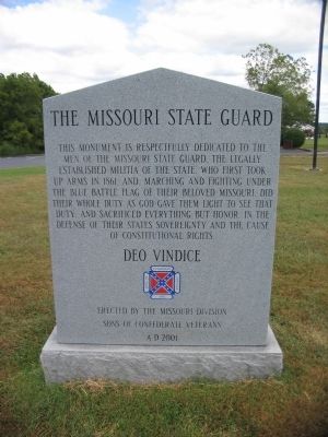
By Craig Swain, August 29, 2010
Missouri State Guard
SHOWN IN SOURCE-SPECIFIED ORDER
| 1 ► Missouri, Greene County, Battlefield — The Battle of Oak Hills — August 10, 1861 — |
| On State Highway ZZ, on the right when traveling north. | |||
| 2 ► Missouri, Greene County, Battlefield, Brookline — Gibson's Mill — Wilson's Creek — |
| On Tour Road, on the right when traveling east. | |||
| 3 ► Missouri, Greene County, Battlefield, Brookline — Way to the Mill — Wilson's Creek — |
| Near Tour Road, on the right when traveling east. | |||
| 4 ► Missouri, Greene County, Battlefield, Brookline — Signs From The Past — Wilson's Creek — |
| Near Tour Road, on the right when traveling east. | |||
| 5 ► Missouri, Greene County, Battlefield, Brookline — Gibson's Mill Site — Wilson's Creek — |
| Near Tour Road, on the right when traveling east. | |||
| 6 ► Missouri, Greene County, Battlefield, Brookline — Gibson's House Site — Wilson's Creek — |
| Near Tour Road, on the right when traveling east. | |||
| 7 ► Missouri, Greene County, Battlefield, Brookline — Ray Springhouse — Wilson's Creek — |
| On Tour Road, on the left when traveling south. | |||
| 8 ► Missouri, Greene County, Battlefield, Brookline — The Ray Family — Wilson's Creek — |
| Near Tour Road, on the left when traveling south. | |||
| 9 ► Missouri, Greene County, Battlefield, Brookline — Fight in Ray's Cornfield — Wilson's Creek — |
| Near Tour Road, on the left when traveling south. | |||
| 10 ► Missouri, Greene County, Battlefield, Brookline — Price's Headquarters — Wilson's Creek — |
| On Tour Road, on the right when traveling south. | |||
| 11 ► Missouri, Greene County, Battlefield, Brookline — Pulaski Arkansas Battery — Wilson's Creek — |
| On Tour Road, on the right when traveling south. | |||
| 12 ► Missouri, Greene County, Battlefield, Brookline — A Union Plan / The Broken Pincer — Wilson's Creek — |
| Near Tour Road, on the left when traveling south. | |||
| 13 ► Missouri, Greene County, Battlefield, Brookline — Pulaski Arkansas Battery — Wilson's Creek — |
| Near Tour Road, on the right when traveling south. | |||
| 14 ► Missouri, Greene County, Battlefield, Brookline — The Eye of the Storm — Wilson's Creek — |
| Near Tour Road, on the right when traveling south. | |||
| 15 ► Missouri, Greene County, Battlefield, Brookline — Sigel's Attack — Wilson's Creek — |
| On Tour Road, on the left when traveling west. | |||
| 16 ► Missouri, Greene County, Battlefield, Brookline — Rout of Sigel's Column — Wilson's Creek — |
| On Tour Road, on the left when traveling west. | |||
| 17 ► Missouri, Greene County, Battlefield — Guibor's Battery — Wilson's Creek — |
| On Tour Road, on the right when traveling north. | |||
| 18 ► Missouri, Greene County, Battlefield — Bloody Hill — Wilson's Creek — |
| On Tour Road, on the right when traveling north. | |||
| 19 ► Missouri, Greene County, Battlefield, Brookline — XIV — Death of Brigadier General Nathaniel Lyon — |
| Near Tour Road, on the right when traveling north. | |||
| 20 ► Missouri, Greene County, Battlefield — Battle's Beginning ... and End — Wilson's Creek — |
| Near Tour Road, on the right when traveling north. | |||