By Paul Crumlish, July 15, 2011
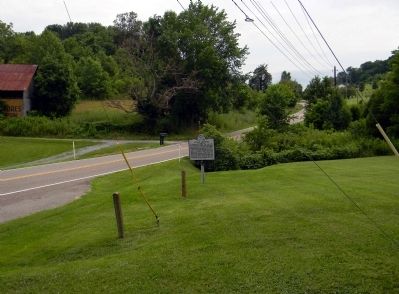
Wide view of the Acuff Chapel Marker
GEOGRAPHIC SORT Title Sort Marker Number Sort Marker Number Sort N Marker Number Sort T Publication Order Sort Publication Order Sort A Erected Year Sort Most Viewed Sort Most Recent-Interest Sort Most Recently Changed Sort SEE FAQ #33 FOR DESCRIPTIONS
On Memorial Boulevard (State Road 126) 0.7 miles west of Barr Road, on the right when traveling west.
On Bluff City Highway (State Highway 390) at Salls Road on Bluff City Highway.
On Knob Creek Rd at W, Market St. on Knob Creek Rd.
On Christanna Highway (Virginia Route 46) 0.5 miles north of Gasburg Road (County Road 626), on the right when traveling north.
On Christanna Highway (Virginia Route 46) 0.1 miles south of Gasburg Road (County Road 626), on the left when traveling north.
On Boydton Plank Road (U.S. 1) 0.1 miles south of Flat Rock Road (County Route 643), on the right when traveling north.
On South Main Street (U.S. 301) at Greensville Avenue, on the right when traveling south on South Main Street.
On South Washington Street (U.S. 29) at Hillwood Avenue (Virginia Route 338), on the right when traveling north on South Washington Street.
On Pleasant Shade Drive (U.S. 58) 0.5 miles west of Grassy Pond Road (Virginia Route 606), on the right when traveling east.
On East Queen Street just east of Wine Street, on the right when traveling east.
On West Bruce Street just west of South Main Street (U.S. 11), on the right when traveling west.
On Benns Church Boulevard (Virginia Route 10) south of Brewers Neck Road (U.S. 238), on the right when traveling north.
Near North Cumberland Road, 0.3 miles north of Wilderness Road (U.S. 58), on the right when traveling north.
On Cornwall Street just west of Wirt Street Northwest, on the right when traveling west.
On West Danville Street (U.S. 1) at Goodes Ferry Road, on the left when traveling south on West Danville Street.
Paid Advertisement
On Fleetwood Drive (County Route 611), on the right when traveling south.
On Lee Hwy (U.S. 11) at Hickman Cemetery Road/New River Road (County Route 624), on the right when traveling south on Lee Hwy.
On East Franklin Street at North 19th Street, on the left when traveling east on East Franklin Street.
On Virginia Route 107 just north of Sulphur Springs Road (County Route 639), on the right when traveling north.
On Partlow Road (County Route 738) 2.6 miles south of Courthouse Road (Virginia Route 208), on the left when traveling south.
On South County Drive (U.S. 460) at Walnut Hill Road, on the right when traveling west on South County Drive.
On Royal Avenue (U.S. 340) at Rocky Lane (County Route 607), on the right when traveling south on Royal Avenue.
On Jamestown Road (Virginia Route 5) just south of Cary Street, on the left when traveling south.
On South Braddock Street (U.S. 11) at Wolfe Street, on the right when traveling south on South Braddock Street. Reported permanently removed.
On Cold Stream Road (County Road 15) just south of Clark Hillside Drive, on the right when traveling north.
On Fort Martin Road (County Route 53) just south of the Pennsylvania state line, on the left when traveling south.
Near Rehoboth Church Road (Local Route 3/8) north of West Virginia Route 3.
On West Virginia Route 3 at Rehoboth Church Road (Local Route 3/8) on State Route 3.
On South Washington Street (U.S. 522) north of Market Street.
On Main Street (U.S. 219), on the right when traveling north.
On U.S. 219 just north of U.S. 250, on the right when traveling north.
Paid Advertisement
131 entries matched your criteria. Entries 101 through 131 are listed above.
⊲ Previous 100