By J. J. Prats, September 29, 2018
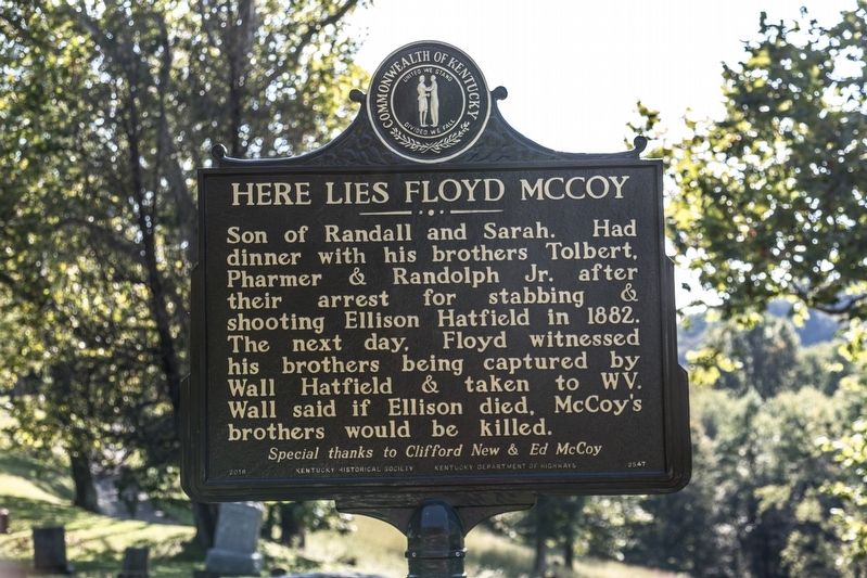
Here Lies Floyd McCoy side of marker
GEOGRAPHIC SORT Title Sort Marker Number Sort Marker Number Sort N Marker Number Sort T Publication Order Sort Publication Order Sort A Erected Year Sort Most Viewed Sort Most Recent-Interest Sort Most Recently Changed Sort SEE FAQ #33 FOR DESCRIPTIONS
Near Cemetery Road (Local Route 3294) at 36th Street and Radio Park Road (Local Route 3294).
On Kentucky Route 1056 just south of River Street, on the right when traveling north.
On Kentucky Route 319, 0.7 miles west of Right Turkey Toe Branch, on the left when traveling west.
On Kentucky Route 312, 0.7 miles west of Right Turkey Toe Branch, on the right when traveling east.
On Kentucky Route 319, 0.2 miles east of Compton Road, on the left when traveling east.
On State Highway 319, 0.7 miles Right Turkey toe Branch, on the left when traveling west.
On Toler Road (Kentucky Route 319) west of Kentucky Route 1056, on the right when traveling west.
On Toler Road (Kentucky Route 319) west of Kentucky Route 1056, on the right when traveling west.
On Toler Road (Kentucky Route 319) 0.1 miles west of Kentucky Route 1056, on the right when traveling west.
On Kentucky Route 1056 south of River Street, on the right when traveling north.
Near Chloe Road (Kentucky Route 1460) east of South Bypass Road (Kentucky Route 1460), on the left when traveling east.
On Kentucky Avenue, on the left when traveling north.
On Chloe Road (Kentucky Route 1460) east of South Bypass Road (Kentucky Route 1460), on the right when traveling east.
On Scott Avenue at Main Street, on the right when traveling east on Scott Avenue.
On Division Street east of Main Street, on the right when traveling east.
Paid Advertisement
On Big Blue Springs Road south of State Route 1056, on the left when traveling south.
On Lower Stringtown Road at Kentucky Route 292, on the right when traveling west on Lower Stringtown Road.
Near Lower Stringtown Road at Kentucky Route 292, on the right when traveling west.
On Kentucky Route 292 at Lower Stringtown Road, on the right when traveling south on State Route 292.
On Jerry West Highway (West Virginia Route 44), on the right when traveling south.
On Warm Hollow Road at Magnolia Avenue (West Virginia Route 49), on the right when traveling north on Warm Hollow Road.
On Mate Street (West Virginia Route 49) at Bridge Street, on the left when traveling south on Mate Street.
On State Highway 1056 at Main Street, on the right when traveling south on State Highway 1056.