Near Park Road 49, 0.3 miles west of Klein Road, on the left when traveling west.
Here on these familiar hills under these expansive skies and under these oak trees that he loved so much, his life has come full circle ...
his roots go deep here on this spot in the hill country.
From the eulogy delivered here by the . . . — — Map (db m91149) HM
On Park Road 49, 0.6 miles west of Klein Road, on the right when traveling west.
The welcome mat at the Johnson home read, “All the World is Welcome here.” But as the house became an alternate White House it soon became clear there was not enough room. Describing the steady stream of visitors in her home, Lady Bird . . . — — Map (db m91206) HM
On Malecek Road, 0.5 miles Park Road 49, on the right.
From his childhood and throughout his political career, Lyndon Johnson drew from his western heritage. The grandson of a Chisholm Trail cattle drover never forgot that “can do” spirit of the cowboy way. The LBJ Ranch was the best place . . . — — Map (db m91272) HM
The Secret Service had a presence in the Johnson family for forty-six years beginning on January 20, 1961 when Lyndon Johnson was inaugurated as vice president. Over that lifetime of service, agents witnessed many events, both in Washington and . . . — — Map (db m91316) HM
On Park Road 49, 0.1 miles west of Bailey Road, on the left when traveling west.
For many years this low-water crossing served as the primary access to the LBJ Ranch; for non-Texans, it served as a dramatic entry into LBJ’s world. The construction of this dam and crossing was the first improvement made to the ranch by Lyndon . . . — — Map (db m91317) HM
Near Peach Street at Loring Street, on the right when traveling east.
Originally the Camp Swift Post Office, this building was purchased from the United States government, rebuilt by the citizens of Stonewall and dedicated as a gymnasium on May 1, 1949.
While continuing to serve the community, an international . . . — — Map (db m90993) HM
On Park Road 49, 0.6 miles west of Klein Road, on the right when traveling west.
The scene was a common one: young Lyndon Johnson, only a few years old, toddling down the road to visit his grandparents in this house. Here he found a ready supply of apples, candy, and affection. The future president felt a powerful attraction to . . . — — Map (db m91208) HM
Here, costumed interpreters carry out the day-to-day activities of a turn-of-the-century German-Texas farm family. You might spot them plowing the garden with a team of horses, or watch them tend the farm animals. Daily chores include milking, . . . — — Map (db m91055) HM
On Bailey Road, 0.5 miles north of Park Road 49, on the left when traveling north.
Growing up in the scenic Texas Hill Country, Lyndon Johnson developed a deep appreciation and respect for the land. As part of his dream for a “Great Society” he felt a responsibility to protect the natural heritage of the United States. . . . — — Map (db m91235) HM
On Malecek Road, 0.1 miles north of Park Road 49, on the right when traveling south.
In October 1961 the United States Air Force replaced twin engine, propeller driven aircraft with the four engine Lockheed JetStar for executive transport.
Lyndon Johnson was the first Vice President to have an aircraft assigned to him. His . . . — — Map (db m91281) HM
On Park Road 49 at Klein Road, on the right when traveling west on Park Road 49.
Lyndon Baines Johnson first came to this school as a four-year-old in knee breeches and a collar. Here, surrounded by 30 students spanning seven grades, he received his first formal education. The future president attended the Junction School for . . . — — Map (db m91132) HM
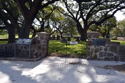
Near Park Road 49, 0.3 miles west of Klein Road, on the right when traveling west.
“I have a mighty fine grandson, smart as you find them. I expect him to be United States Senator before he is forty.”
Grandfather Sam Ealy Johnson, Sr., on young Lyndon Johnson
On this site on a rainy August night in . . . — — Map (db m91148) HM
On Malecek Road, 1.2 miles north of Park Road 49, on the right when traveling south.
Although ranching produced just a fraction of the Johnson’s income, it constituted a major portion of the President’s public identity. The Johnsons maintained two herds of cattle on the LBJ Ranch—one of them a commercial herd sold for beef, . . . — — Map (db m91270) HM
Although he frequented Washington for much of his adult life, President Johnson always considered this house his home. During the White House years, it served as a busy office, a working ranch, and a quiet refuge from the pressures of being . . . — — Map (db m91313) HM
On Malecek Road, 1.2 miles north of Park Road 49, on the right when traveling south.
This, said Lyndon Johnson, was “where the cattle go out and the money comes in.” In the working pens, ranch hands tended to the herds—branding, castrating, doctoring, and, most importantly, loading cattle out for shipment after a . . . — — Map (db m91269) HM
On Bailey Road, 1 mile north of Park Road 49, on the left when traveling west.
In the Texas Hill Country water is more precious than gold. The Pedernales River and the many local creeks are the main sources of water for irrigation. As droughts are common here, supplemental irrigation was necessary for President Johnson to . . . — — Map (db m91238) HM
The statue which stands before you is of Lyndon Baines Johnson, the 36th president of the United States. It was donated by A.W. Moursand, a prominent attorney and past Texas Parks and Wildlife Commissioner. President Johnson wanted this statue . . . — — Map (db m91013) HM
Within These Walls
Discover how the Behrens family lived during the 1870s by exploring this cabin
Home Away From Home
Heinrich and Wilhemina Behrens, pictured here, emigrated from Germany but never forgot their heritage as . . . — — Map (db m91093) HM
On T J Taylor Avenue (State Highway 449) at Kay Street, on the right when traveling north on T J Taylor Avenue.
On December 22, 1912, in the family home 2.7 miles south, was born Claudia Alta Taylor.
She was third child (only daughter) of Thomas Jefferson and Minnie Pattillo Taylor.
Her father had a general store in Karnack for many years. Young “Lady . . . — — Map (db m110848) HM
Near American Legion Memorial Highway (U.S. 281) at Plum Street, on the right when traveling south.
Mineral springs such as nearby Hancock Springs flow into Sulphur Creek, providing Lampasas with waters for recreation and health. The Hancock Springs tract became a fashionable tourist attraction and convention and encampment site in the late 19th . . . — — Map (db m71109) HM
On Quitman Street at North Texas Street (Farm to Market Road 2795), on the right when traveling west on Quitman Street.
The community of Emory was once called Springville, part of Wood County. In 1870, the Texas Legislature created Rains County from portions of four other counties. Named for early Texas patriot Emory Rains, the county chose Springville as its center . . . — — Map (db m139154) HM
On East 1st Street at South Cedar Street (U.S. 285), on the left when traveling west on East 1st Street.
Nationally famed melon, originated in this city. Residents from 1880s grew melons in gardens, noting sun and soil imparted a distinctive flavor. Madison L. Todd (March 22, 1875-Sept. 10, 1967) and wife Julia (Jan. 30, 1880-Feb. 5, 1969) came here . . . — — Map (db m61270) HM
On West 14th Street east of Lavaca Street, on the right when traveling east.
Texas statesman Price Daniel (1910-1988) was born in Dayton, Texas, the son of M.P. and Nannie Partlow Daniel. His career in state and national politics spanned six decades and included service in all three branches of state government.
After . . . — — Map (db m25823) HM
On Haskell Street east of Waller Street, on the right when traveling east.
In 1940, the City of Austin procured and donated 30 acres of land at this site to the US Fish Commission to raise fish for stocking ponds and lakes. Pumps installed in the Colorado River fed irrigation ditches that filled 19 ponds used to raise . . . — — Map (db m150328) HM
Near Red River Street, 0.1 miles north of Clyde Littlefield Drive.
The Lyndon Baines Johnson Library and Museum was designed by Gordon Bunshaft of Skidmore Owings & Merrill (SOM) and opened in the spring of 1971. The design featured the monumental library building clad in Roman travertine and an expansive plaza . . . — — Map (db m35834) HM
On East North Street at North Getty Street (U.S. 83), on the right when traveling west on East North Street.
This four-story hotel building was constructed in 1927 by the family of William Davis "Billy" Kincaid (b. 1854) in memory of his life as a prominent Uvalde cattleman, businessman, and civic leader. The Kincaid Hotel became a popular place for . . . — — Map (db m64463) HM
Settlers in the farming and ranching community of Florence gathered in April 1856 to hear the Rev. Robert Hay Taliaferro (1824-1875) preach and help them formally organize a church. Originally known as the Baptist Church of Christ, the . . . — — Map (db m3303) HM
Near Grand View Point Road, on the right when traveling south.
Wilderness is a word of many meanings. From a place to be feared to a place to be revered, wilderness evokes images of wild animals, jagged mountains, vast prairies or deserts. For some, wilderness offers physical challenges, solitude or a respite . . . — — Map (db m95082) HM
Near Jones Point Drive, 0.2 miles east of South Lee Street, on the right when traveling east.
Theodore Roosevelt Island
This wooded island is a tribute to the vision of our 26th president. Explore, on foot, 2.5 miles of trails and the memorial plaza.
Lady Bird Johnson Park
Take time to visit the Lyndon Baines Johnson . . . — — Map (db m233790) HM
On Mount Vernon Trail north of Four Mile Run Trail, on the right when traveling south.
U.S. Marine Corps War Memorial
Learn more about the U.S. Marine Corps' long history of service. Sculpted from a famous photograph of the second flag-raising during the World War II battle for Iwo Jima, the monument honors all Marines who . . . — — Map (db m130982) HM
On Mount Vernon Trail, on the right when traveling south.
Theodore Roosevelt Island
This wooded island is a tribute to the vision of our 26th president. Explore, on foot, 2.5 miles of trails and the memorial plaza.
Lady Bird Johnson Park
Take time to visit the Lyndon Baines Johnson . . . — — Map (db m134964) HM
Near Jefferson Davis Highway (U.S. 1) 0.1 miles south of Joplin Road (Virginia Route 619), on the right when traveling south.
In honor and memory of the defenders of the Khe Sanh Combat Base in the Republic of Vietnam from 20 January to 01 April 1968. During this period the 26th Marines and their supporting units, held the vital base and positions on Hills 881, 861, . . . — — Map (db m168486) HM WM
On Beechurst Avenue (West Virginia Route 7) north of 7th Street when traveling north.
In 1891, a small group of glass-making artisans from Seneca County, Ohio, founded the Seneca Glass Company. For almost 100 years, Seneca Glass Company’s highly skilled craftspeople manufactured glassware and exquisitely etched lead crystal by hand, . . . — — Map (db m74624) HM
On Summersville Lake Road (West Virginia Route 129) 0.3 miles west of Reservoir Street, on the right when traveling west.
Summersville Reservoir
Constructed
Under the Supervision
of the
United States Army
Corps of Engineers
Huntington District
1960 - 1966
District Engineer: Col. S. Malevich 1959-1962
District Engineer: Col. H. W. . . . — — Map (db m165258) HM
On U.S. 18 at milepost 39 near Silver Springs Road, on the left when traveling west.
Although paved highways have existed in the U.S. since the 1920s, rest areas are a more recent feature of highway travel. In the 1960s, President Lyndon Johnson and First Lady, Lady Bird Johnson promoted a nationwide effort to beautify highways . . . — — Map (db m98300) HM
[Exhibit #1 and #2]
Replica of Friendship 7 capsule that carried John Glenn on his historic orbital flight of Feb. 20, 1962. The capsule was 9 feet long and 6 feet across at its base. At reentry it weighed about 3,000 pounds. Space . . . — — Map (db m80425) HM
On 0 Avenue (Interstate 5), on the left when traveling south.
Upper marker:
This unfortified boundary line between the
Dominion of Canada
and the
United States of America
should quicken the remembrance of the more than century old friendship between these countries
A lesson of peace . . . — — Map (db m27450) HM
Mrs. Lyndon B. Johnson and Mrs. Lester B. Pearson Together opened the Roosevelt Campobello Park on the twenthieth day of August 1964 Lyndon Baines Johnson President of the United States of America and Lester Bowles Pearson Prime Minister of Canada . . . — — Map (db m25394) HM
140 entries matched your criteria. Entries 101 through 140 are listed above. ⊲ Previous 100