Marker Logo
THE HISTORICAL
MARKER DATABASE
“Bite-Size Bits of Local, National, and Global History”


13 entries match your criteria.  


Door County Coastal Byway (Wisconsin) Historical Markers

The Door County Coastal Byway is a 66-mile loop on Wisconsin highways 42 and 57 through the bucolic northern part of Door County. Stretching from just north of Sturgeon Bay (where 42 and 57 diverge) to northern tip of the peninsula at Northport, the byway includes scenery of the Niagara Escarpment as well as the Lake Michigan and Green Bay shores. The Door County Coastal Byway was designated a Wisconsin Scenic Byway in 2009, and a National Scenic Byway in 2021. In 2013, the Byway began erecting kiosks, each with multiple historical markers describing local attractions. As of 2024, there are 11 kiosks, the southernmost being south of Sturgeon Bay (not technically part of the Byway) and the northernmost at the "Devil's Door" where the peninsula ends.
 
Photo Credit: Wisconsin Historical Society, July 20, 2018
Marker detail: View looking south toward downtown Egg Harbor, 1925
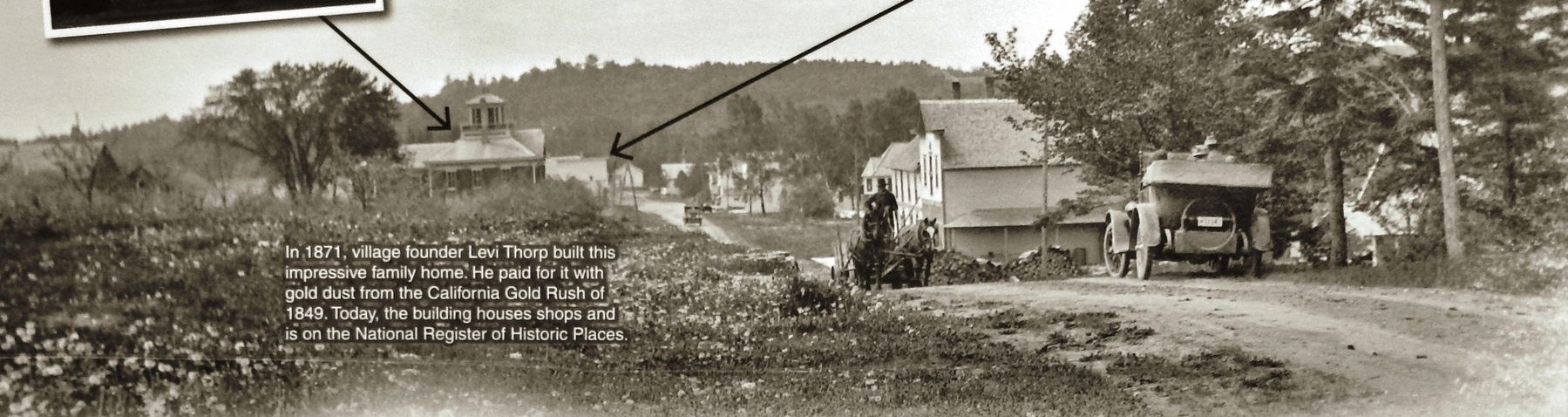
1 Wisconsin, Door County, Egg Harbor — Egg Harbor — A Prosperous Village on the Bay
Blessed with good farmland and a deep water port, Egg Harbor has thrived since its beginning in 1861. In the early years, Egg Harbor served fishermen, farmers, and lumbermen. It was the first community in Door County to hard surface its road. . . . Map (db m130495) HM
2 Wisconsin, Door County, Ellison Bay — Ellison Bay — Town of Liberty Grove
The land surrounding you was once owned by John Ellison. Johan Eliason, later known as John Ellison, was a Danish immigrant who founded this community in 1865. He purchased 8,000 acres of land including a mile of shoreline, and advertised in . . . Map (db m130477) HM
3 Wisconsin, Door County, Ellison Bay, Liberty Grove — A Grand View — Scenic Overlook and Park
This view has inspired people for more than a century. From this vantage point, you can see Ellison Bay nestled into the wooded bluffs of the Niagara Escarpment, the waters of Green Bay, and Washington Island in the distance. A Door . . . Map (db m254230) HM
4 Wisconsin, Door County, Ellison Bay, Liberty Grove — Niagara Escarpment
The limestone bluffs you see along Green Bay are part of the same formation that Niagara Falls plunges over in New York. The Niagara Escarpment arches for a thousand miles around the Great Lakes. Lower layers of soft, erodible shale are . . . Map (db m130478) HM
5 Wisconsin, Door County, Ellison Bay, Liberty Grove — This Is Karst Country — Caves by Land and Sea
The Door Peninsula is a dynamic landscape formed by water and limestone. The Niagara Escarpment, a high limestone ridge along Green Bay, tilts at a 6-degree angle toward Lake Michigan where it disappears under water. This limestone is . . . Map (db m254228) HM
6 Wisconsin, Door County, Fish Creek — Niagara Escarpment
Peninsula State Park protects the largest contiguous tract of Niagara Escarpment in Wisconsin. This limestone ridge was formed by the deposit of ocean animals, plants, and mud on the floor of an ancient sea. Today, rare plants flourish in the . . . Map (db m230277) HM
7 Wisconsin, Door County, Fish Creek — Town of Gibraltar — A Summer Tourist Haven
One hundred years ago, the Fish Creek dock was a bustling portal to a summer vacationland. Arriving tourists, decked out in elegant clothes, waved cheerfully as steamers delivered them from the summer heat of Chicago and Milwaukee. Many . . . Map (db m230274) HM
8 Wisconsin, Door County, Liberty Grove — Door County Coastal Byway / Northern Door Interior
Welcome to the Door County Coastal Byway Discover the true spirit of Door County. Travel this scenic byway as it loops 66 miles along the Green Bay bluffs and through the dunes and bays of Lake Michigan. Explore lighthouses, nature . . . Map (db m229711) HM
Paid Advertisement
9 Wisconsin, Door County, Liberty Grove — Town of Liberty Grove — Legends of Death's Door
Porte des Morts, or Death's Door, is the treacherous strait that separates the peninsula from the Grand Traverse Islands. French explorers named it after hearing tales of native warriors who perished in the turbulent waters. The strait . . . Map (db m193878) HM
10 Wisconsin, Door County, Sevastopol — A Fortunate Mix — Fruitful Soils and Climate
Sevastopol orchards thrive in an ideal blend of climate and soils. Lime-rich soils provide essential nutrients for fruit trees. In addition, cool spring temperatures moderated by the waters and ice of Lake Michigan and Green Bay delay blooming. . . . Map (db m130498) HM
11 Wisconsin, Door County, Sevastopol — Town of Sevastopol — Orchard Country
Sevastopol is the heart of Door Peninsula's famous fruit orchards. Swiss immigrant Joseph Zettel planted the first orchard one mile from here in 1862. His State Fair apple exhibit led University of Wisconsin scientists Emmett Golf and Arthur . . . Map (db m130496) HM
12 Wisconsin, Door County, Sister Bay — Nature of Sister Bay — A Face to the Sunset
Sister Bay was named For the Sister Islands that Flank its harbor. This pair of small uninhabited islands is a significant nesting site for gulls and terns. The Village of Sister Bay offers the largest public waterfront in Door County for . . . Map (db m229455) HM
13 Wisconsin, Door County, Sister Bay — Village of Sister Bay — A Prosperous Port on Green Bay
Village life has always revolved around this deep water port. The community of Sister Bay was born in 1870 when the firm of Henderson, Coon & Dimond built a pier, sawmill, grist mill, hotel, and two stores. They hired Swedish woodchoppers . . . Map (db m229454) HM
 
 
CeraNet Cloud Computing sponsors the Historical Marker Database.
This website earns income from purchases you make after using our links to Amazon.com. We appreciate your support.
Paid Advertisement
Sep. 11, 2026
