This community was first settled about 1830 when
Solomon Tuttle built his log house. A few years later
his son-in-law, W. D. Cunningham, built the 2-story brick
that is still standing. This home witnessed many historic
events, including the . . . — — Map (db m224757) HM
Significant dates in Fayetteville history include: Incorporated town in 1836; Old Wire road from Jefferson City, Mo. to Ft. Smith cut in 1835; Washington County Fair first held on the Square in 1856; first telegraph installed around 1860; . . . — — Map (db m59877) HM
This 2-story log house and out-buildings were erected by John Latta about 1834 on Evansville Creek, 12 miles southwest of this spot. The Latta settlement was called Vineyard from "The Lord's Vineyard." Vineyard was the first postoffice in Washington . . . — — Map (db m35363) HM
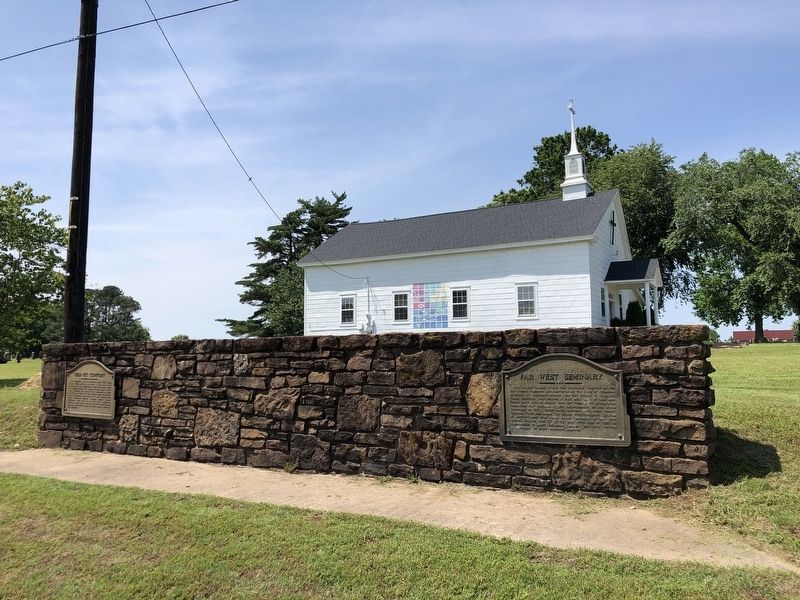
Here on this, the Old Wire Road, was located Fitzgerald's Station on the Butterfield Overland mail route from St. Louis to San Francisco. First trip 1858. Last 1861. Longest and best conducted mail route in the world. 2795 miles. Service twice . . . — — Map (db m59950) HM
Holcomb's Spring, settled in the 1840s, saw many
troop movements during the Civil War. Regular
Baptist Church services halted in January 1862,
as soldiers entered the area. Confederate troops
camped there in October 1862 and July 1863. . . . — — Map (db m224791) HM
The Colony. After the Civil War, African Americans from across the former Confederacy settled here, in a farming community called The Colony. Many owned their own farms and others were sharecroppers. The community established the Mount Olive . . . — — Map (db m229615) HM
Named for Richard Searcy, an early Arkansas territory settler, the city of Searcy was established by the Arkansas State legislature to serve as the county seat in 1837. Early resident and surveyor Israel Moore named the original streets of Searcy . . . — — Map (db m173998) HM
Much of the history of Augusta lies beneath these
grounds. It was the burial ground for the
Chickasaws before the first settlers. The earliest
extant gravestone is Penelopy Simmons, who
operated a hotel in Augusta and died in 1852.
First . . . — — Map (db m116627) HM
Chickasaws and Quapaws crossed the White River
here to visit, long before the first settlers. First
post office, named Chickasaw Crossing in Feb. 1848,
was soon changed to Augusta. Steamboats
docked here to deliver goods and left with . . . — — Map (db m116629) HM
Thomas Hough founded Augusta in 1848, naming
it after his favorite cousin, Miss Augusta Cald,
of Virginia. For generations it was known as
Chickasaw Crossing. The first settlers came in
1820. It was incorporated in 1861. During the
Civil . . . — — Map (db m116630) HM
Noted architect: Charles L. Thompson, Nov 30, 1901
Thomas Hough, founder of Augusta in 1848
built his home on this location before the Civil
War. During the Federal occupation Gen. Frederick
Steele headquartered here. Woodruff County was . . . — — Map (db m116628) HM
Located two and a half miles south was Monrovia, the first county seat of Yell County, and home of William Peavey. Monrovia holds the distinction of having the first post office in the county interior, established February 1828 with W.H. Peavey . . . — — Map (db m156872) HM
Dardanelle was incorporated
January 17, 1855. Dardanelle was
laid off by the owner, Joseph H.
Brearley in October, 1847. His son,
Col. David Brearley, was sent here
as an Indian Agent in 1823 to take a
census of the Indians living in . . . — — Map (db m233691) HM
Buried in this cemetery, is
David Brearley, early settler of
this area and Indian Agent of 1823;
also his son Joseph H. Brearley,
who donated the land and plated
the town of Dardanelle in 1851. — — Map (db m170319) HM
216 entries matched your criteria. Entries 201 through 216 are listed above. ⊲ Previous 100