On Main Street at North Wall Street, on the right when traveling north on Main Street.
(side 1)
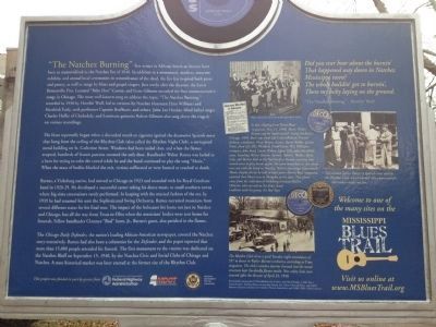
One of the deadliest fires in American history took the lives of over 200 people, including bandleader Walter Barnes and nine members of his dance orchestra at the Rhythm Club (less than a mile southeast of this site) on April 23, . . . — — Map (db m70811) HM
On Main Street east of North Pearl Street, on the right when traveling west.
(side 1)
Clarence “Bud” Scott, Sr., led one of the most popular dance bands in the Mississippi-Louisiana region for several decades beginning around 1900. Scott (1876-1938), a lifelong Natchez resident, was renowned among both . . . — — Map (db m70852) HM
On Washington Street at South Wall Street, on the right when traveling west on Washington Street.
Known as the Spanish Quarter in the early 1800s, this neighborhood is one of the oldest in Natchez. Each corner house dates to before the Civil War.
A Spaniard, Manuel Texada, built the house called Texada . . . — — Map (db m127092) HM
On Silver Street, 0.5 miles south of South Broadway Street, on the right when traveling south.
On May 8, 1840, one of the deadliest tornadoes in American history struck Natchez and killed about 300 people. Most of the dead were boatmen and passengers on steamboats docked at the waterfront. The city was already suffering from the economic . . . — — Map (db m143132) HM
On State Highway 24/48 at East Fork Road, on the right when traveling west on State Highway 24/48.
(Side A)
A Liberty native, Jerry Clower (1926-1998) brought his colorful, observant, comic stories of southern life — developed as a sales tool as he worked as a fertilizer salesman — to live shows, recordings, television, bestselling . . . — — Map (db m92559) HM
On West Washington Street west of North Jackson Street, on the right when traveling west.
(side 1) World-renowned harmonica virtuoso Charlie Musselwhite was born in Kosciusko on January 31, 1944. His great uncle, Lamar Coalson, once owned the store that occupied this site. Musselwhite began playing in Memphis and rose to . . . — — Map (db m130064) HM
On Ripley Avenue (Mississippi Route 370) east of South Main Street, on the right when traveling east.
(side 1)
As a producer, studio engineer, trumpeter and bandleader, Willie Mitchell played a central role in the rise of Memphis as a center for soul music. Mitchell, born in Ashland on March 1, 1928, made many recordings under his own name, . . . — — Map (db m171412) HM
On 1st Street at Fava Street, on the right when traveling north on 1st Street.
Highway 61, "the blues highway," is lined with the birthplaces of blues, R&B, and gospel artists all along its route in Mississippi, and even small communities such as Alligator share in this proud musical legacy. Performers born or raised around . . . — — Map (db m154805) HM
On Lake Street, 0.1 miles south of Roger Street, on the right when traveling north.
Pioneer television producer was born in Dr. Wells' house, which once occupied this site. Coe shows such as "Marty", "The Trip to Bountiful", and "Days of Wine and Roses" set standards for 1950s live TV drama. Producer of stage and film hits "A . . . — — Map (db m154859) HM
On Main Street (State Highway 1) at Preston Street (State Highway 448), on the right when traveling north on Main Street.
Blues saxophonist extraordinaire Eddie Shaw was born on a Stringtown plantation on March 20, 1937. He learned music at school in Greenville and performed in various local bands before moving to Chicago to join the Muddy Waters band. Shaw served as . . . — — Map (db m154795) HM
On Main Street (State Highway 1) at Preston Street (State Highway 448), on the right when traveling north on Main Street.
(Front)
Benoit native Eddie Taylor, an architect of the post-World War II Chicago blues genre, was renowned for his work both as a bandleader and accompanist. He was best known for shaping the distinctive sound of Jimmy Reed, a childhood . . . — — Map (db m154785) HM
On South Chrisman Avenue near Collins Street, on the left when traveling north.
Side 1
During the segregation era many towns in Mississippi had a particular street that served as the center of African American business and social life, catering not only to townsfolk but to farm hands and sharecroppers from the countryside . . . — — Map (db m170498) HM
On South Court Street at North Bolivar Avenue, on the right when traveling west on South Court Street.
While leading his orchestra at a dance on this site c. 1905, Handy was
unable to perform requested blues numbers. A local band stepped in
and stole the show. "My enlightenment came in Cleveland. That night
an American composer was born," he . . . — — Map (db m89932) HM
On Ruby Street near Aloe Avenue, on the right when traveling east.
Side 1
Despite their conceptual differences, gospel, the Sunday morning music of the church, and blues, the Saturday night music of the juke joint, share some of the same roots, influences and musical traits. Many African African singers have . . . — — Map (db m170501) HM
On West Sunflower Road (State Highway 8) at North 2nd Avenue, on the right when traveling west on West Sunflower Road.
Side 1
The Los Angeles-based GRAMMY Museum’s decision to open a sister museum here in Cleveland in 2016 was a testament to Mississippi's rich musical heritage in blues, country, gospel, rock and other genres. Among Mississippi’s many GRAMMY . . . — — Map (db m170502) HM
On South Court Street at North Pearman Avenue, on the right when traveling west on South Court Street.
Front
In W.C. Handy's famous account of his "enlightenment" in Cleveland, a ragged local trio was showered with coins after Handy's orchestra of trained musicians had been unable to similarly excite the crowd. In early manuscripts of . . . — — Map (db m90071) HM
On East Main Street (State Highway 444) at East Park South (Old State Route 61), on the left when traveling west on East Main Street.
(front)
Duncan has earned its place in blues history as the birthplace or former residence of performers who achieved notoriety locally and around the world. The legendary Jimmy Reed lived on the nearby McMurchy plantation in his youth. . . . — — Map (db m154804) HM
On Po Monkey Road, 1.4 miles west of U.S. 61/278, on the left when traveling west.
The rural juke joint played an integral role in the development of the blues, offering a distinctly secular space for people to socialize, dance, and forget their everyday troubles. While many such jukes once dotted the cotton fields of the Delta . . . — — Map (db m174021) HM
On South West Main Avenue, 0.1 miles south of West Martin Luther King Jr Drive, on the right when traveling south.
Front
Music has been one of the many facets of African American culture proudly nurtured by the community of Mound Bayou, ranging from blues and R&B in cafes, lounges, and juke joints to musical programs in schools, studios, and . . . — — Map (db m90065) HM
On Main Street (State Highway 1) at Brown Street, on the left when traveling north on Main Street.
(front)
In his 1936 recording “They’re Red Hot,” bluesman Robert Johnson employed the imagery of a tamale vendor to describe a woman. Made of corn meal and meat, the tamale was a staple in the diet of Mexican migrant laborers in . . . — — Map (db m154799) HM
On Main Street (State Highway 1) at Dr Martin Luther King Street, on the right when traveling north on Main Street.
(front)
Rosedale was immortalized in Robert Johnson's 1937 recording Traveling Riverside Blues. In 1968, Eric Clapton's group Cream incorporated the verse "Goin' down to Rosedale" into their version of Johnson's Cross Road . . . — — Map (db m154800) HM
On Elm Street just south of Cottonwood Street, on the right when traveling north.
David "Honeyboy" Edwards, born in Shaw in 1915, took to the road as a teenager accompanying Big Joe Williams and became a true "rambling" bluesman. Later Edwards traveled with other artists, including Robert Johnson. Edwards recorded blues for the . . . — — Map (db m170687) HM
On North Broadway Street at West 2nd Avenue (State Highway 32), on the left when traveling north on North Broadway Street.
(front)
Henry Townsend, the only blues artist to have recorded during every decade from the 1920s to the 2000s, was born in Shelby on October 27, 1909. A longtime resident of St. Louis, where he was hailed as a patriarch of the local blues . . . — — Map (db m154802) HM
On Hofstra Road at Waxhaw Road, on the right when traveling south on Hofstra Road.
Otis Clay, one of America’s premier singers of soul and gospel music, was born in Waxhaw on February 11, 1942. His storied journey to international renown began at the age of four at the Tree of Life Missionary Baptist Church here, where he attended . . . — — Map (db m174025) HM
On Martin Luther King Memorial Drive (State Highway 161) at Mixson Street, on the right when traveling north on Martin Luther King Memorial Drive.
The Harlem Inn, known as “The Showplace of the South,” was once the Delta’s most important venue for touring national blues performers. B. B. King, Little Milton, Bobby “Blue” Bland, Howlin’ Wolf, Tyrone Davis, and T-Bone Walker were among the many . . . — — Map (db m170496) HM
On Public Square east of South Newberger Avenue, on the left when traveling east.
Front
The musical heritage of Calhoun County was illuminated in 2014 via international acclaim for longtime Bruce resident and Sabougla native Leo “Bud” Welch, The guitarist and vocalist began playing blues in his teens and returned to . . . — — Map (db m107618) HM
On Mississippi Route 7 at Avalon Road (County Road 41), on the right when traveling south on State Route 7.
John S. Hurt (1893-1966) was a
pioneer blues and folk guitarist.
Self-taught, Hurt rarely left his
home at Avalon, where he worked
as a farmer. Although he recorded
several songs in 1928, including
"Avalon Blues" and "Frankie,
he lived in . . . — — Map (db m160396) HM
On County Road 41, 0.3 miles east of County Road 254, on the right when traveling east. Reported damaged.
World-renowned master of the acoustic guitar John Hurt, an important figure in the 1960s folk blues revival, spent most of his life doing farm work around Avalon in Carroll County and performing for parties and local gatherings. Hurt . . . — — Map (db m160397) HM
On Jackson Street east of Lexington Street (State Route 17), on the right when traveling east.
Blending blues and old-time dance tunes,
fiddler William T. Narmour (1889-1961) and
guitarist Shellie W. Smith (1895-1968) became an
influential duo with forty-eight recordings for
Okeh and Bluebird records from 1928 to 1934 that
often . . . — — Map (db m170375) HM
On Woodland Circle, 0.1 miles north of Starkville Road, on the left when traveling north.
(Side 1)
Houston area native Booker T. Washington White (c. 1904–1977) was one of the most expressive vocalists and powerful slide guitarists in the blues. A remarkable lyricist as well, he recorded such classics as “Shake ‘Em On . . . — — Map (db m155277) HM
On County Highway 419, 0.7 miles east of County Highway 80, on the left when traveling east.
(Side 1)
Formed in 1987 when three local musicians — Joe Lee Huffman, Willie Gene Huffman, and Robert Eaton — got together to play music and share supper, the Sparta Opry has become a community institution. Having offered more than 100 country, . . . — — Map (db m155271) HM
On East Main Street, 0.1 miles east of South Commerce Street, on the right when traveling east. Reported damaged.
[Front]
Choctaw County fiddler Hoyt Ming (1902-1985) led the lively string band recorded as “Floyd Ming & His Pep Steppers” at a Memphis Victor session in 1928. His “Indian War Whoop,” with its fiddling “holler,” became an old-time country . . . — — Map (db m140731) HM
On East Main Street east of South Commerce Street, on the right when traveling east.
"Two Steps From the Blues" might refer to Choctaw County's location, a bit off the path from the well-known blues highways and byways of Mississippi, but it is also the title of a classic blues song written by a native of Ackerman, "Texas" Johnny . . . — — Map (db m51199) HM
On Fair Street at Market Street, on the right when traveling east on Fair Street.
Lil Green was known as the Queen of the Blues in the early 1940s when her distinctive, seductive voice was highlighted on “Romance in the Dark,” “Why Don’t You Do Right?” and other blues and pop songs recorded for the Bluebird label. Born Lillie . . . — — Map (db m143094) HM
On Carroll Street /Rodney Road at Main/Market Street, on the right when traveling east on Carroll Street /Rodney Road. Reported missing.
During the first half of the 20th century, the African American Rabbit Foot Minstrels entertainers played a major role in spreading the blues via tours across the South. Founded in 1900, the “Foots” were headquartered in Port Gibson between 1918 and . . . — — Map (db m35545) HM
On East Broad Street east of Commerce Street, on the right when traveling east.
One of the giants of post-World War II Chicago blues, Chester Arthur Burnett, aka “Howlin’ Wolf,” was born in White Station, just north of West Point, on June 10, 1910. In his early teens Burnett began performing in the Delta and was . . . — — Map (db m50299) HM
On Bobo-New Africa Road west of West Bobo Road, on the right when traveling west.
Little Junior Parker, one of the most outstanding blues singers of the 1950s and ‘60s, was born on a plantation near Bobo on March 27, 1932. As a youngster Parker moved with his mother to West Memphis, and he recorded his first hit, “Feelin’ Good,” . . . — — Map (db m174029) HM
On Sunflower Avenue at Martin Luther King Boulevard, on the left when traveling north on Sunflower Avenue.
Front
The Clarksdale area is famed for its many legendary blues artists who achieved their greatest success after moving away, such as Muddy Waters, Ike Turner, and John Lee Hooker. But there were world-renowned musicians who . . . — — Map (db m90061) HM
Front
The Delta Blues Museum, the world's first museum devoted to blues, was founded on January 31, 1979, by Sid Graves, director of Clarksdale's Carnegie Public Library. Originally housed in a room of the Myrtle Hall Elementary . . . — — Map (db m90046) HM
On 3rd Street at Yahoo Avenue, on the left when traveling east on 3rd Street.
Front
Rock ‘n’ roll and rhythm & blues pioneer Ike Turner began his career playing blues and boogie woogie piano in Clarksdale. Turner was born less than a mile south-west of this site, at 304 Washington Avenue in the Riverton . . . — — Map (db m90041) HM
On Issaquena Avenue, 0.1 miles north of Martin Luther King Boulevard, on the right when traveling south.
Front
The golden voice of Sam Cooke thrilled and enchanted millions of listeners on the hit recordings “You Send Me,” “Shake,” “A Change is Gonna Come,” “Chain Gang,” and many more. . . . — — Map (db m90050) HM
Front
The Sunflower River Blues & Gospel Festival, a preeminent showcase for homegrown Mississippi talent, began in 1988 as a promotion to draw area shoppers to downtown Clarksdale. The festival's dedication to presenting authentic . . . — — Map (db m90047) HM
On Martin Luther King Boulevard at Harrison Avenue, on the right when traveling east on Martin Luther King Boulevard.
Front
This neighborhood, known since the turn of the twentieth century as the New World, was a breeding ground for ragtime, blues, and jazz music in Clarksdale's early days as a prosperous and adventurous new cotton town, when . . . — — Map (db m90060) HM
On Issaquena Avenue at Blues Alley, on the right when traveling south on Issaquena Avenue.
"Father of the Blues" composer and family lived at this site 1903-05. In
Clarksdale Handy was influenced by Delta blues which he collected
and later published as well as his own famous and influential music. — — Map (db m89929) HM
On Issaquena Avenue at Blues Alley, on the right when traveling south on Issaquena Avenue.
Front
One of Clarksdale's most talented and renowned blues musicians, Wade Walton (1923-2000) chose to pursue a career as a barber rather than as a professional entertainer. Walton never lost his love for blues, however, and often . . . — — Map (db m90049) HM
On Delta Avenue, 0.1 miles south of East 2nd Street, on the right when traveling south.
Front
WROX, Clarksdale’s first radio station, went on the air on June 5, 1944, from studios at 321 Delta Avenue. From 1945 until 1955 the station was headquartered here at 257 Delta. Legendary disc jockey Early “Soul Man” . . . — — Map (db m90033) HM
On 2nd Street at Washington Street, on the left when traveling north on 2nd Street.
Side 1
Born in Friar’s Point as Harold Lloyd Jenkins, son of a ferryboat captain, Conway Twitty (1933-1993) first achieved stardom as a bluesy rockabilly singer. Beginning in the 1970s, he became one of country’s bestselling balladeers ever, with . . . — — Map (db m170382) HM
On 2nd Street north of Webb Street, on the right when traveling north.
Robert Nighthawk (1909-1967) was one of the foremost blues guitarists of his era. Although he rarely stayed long in one town, he called Friars Point home at various times from the 1920s to the 1960s. In a 1940 recording, he sang of “going back to . . . — — Map (db m160406) HM
On Commissary Circle at Hopson Road, on the left when traveling north on Commissary Circle.
Front
One of the major factors behind the “great migration” of African Americans from the South to northern cities was the mechanization of agriculture, which diminished the need for manual laborers. In 1944 the Hopson . . . — — Map (db m90029) HM
On South Front Avenue at 2nd Street, on the left when traveling north on South Front Avenue.
Front
The Lula area has been home to legendary Mississippi blues performers Charley Patton, Son House, Frank Frost, and Sam Carr. Patton immortalized Lula in the lyrics of his recordings “Dry Well Blues” (1930) and . . . — — Map (db m107619) HM
On Park Street south of Hopson Street, on the right when traveling south.
The 1951 classic Rocket “88” by Jackie Brenston and his Delta Cats has often been cited as the first rock ’n’ roll record. Waxed at Sam Phillips’ Memphis Recording Service, it was also the first No. 1 rhythm & blues hit for Chicago-based Chess . . . — — Map (db m174032) HM
On Chautauqua Drive, 0.5 miles west of U.S. 51, on the right when traveling west.
The original amphitheater constructed of terraced ground and covered with sawdust sloping downward to the covered tabernacle was originally constructed in 1872 when the Brookhaven District of the United Methodist Church founded Hennington . . . — — Map (db m182923) HM
On West Railroad Avenue at West Georgetown Street, on the right when traveling south on West Railroad Avenue.
Tommy Johnson (1896-1956) was one of the most influential blues artists in Mississippi in the 1920s and 1930s. He grew up in the Crystal Springs area, where he often performed with his brothers LeDell and Mager. His original songs, which were widely . . . — — Map (db m50895) HM
On Caldwell Drive (U.S. 51) at West Gallatin Street, on the left when traveling south on Caldwell Drive.
Robert Johnson born Hazelhurst, Mississippi May 8, 1911 Copiah County
Robert Johnson recording career left an enormous legacy to American music. The body of his work is considered to be the most powerful of its kind.
His music struck a . . . — — Map (db m50874) HM
On South Ragsdale Avenue at West Gallatin Street, on the right when traveling north on South Ragsdale Avenue.
Front
The legendary bluesman Robert Johnson was born on the northern outskirts of Hazlehurst to Julia Major and Noah Johnson, on May 8, 1911 (or possibly 1912). Johnson lived in Tunica County and in Memphis as a child, but in the early . . . — — Map (db m81864) HM
On Gerald McRaney Street at South Elm Avenue, on the right when traveling north on Gerald McRaney Street.
This native son, through his celebrity status as a television and motion picture actor, has brought recognition to this community. Because his life was shaped by his heritage, he returns to his grassroots each year to visit family and friends. This . . . — — Map (db m170481) HM
On Park Street at West Street, on the right when traveling west on Park Street.
The Hernando area was the birthplace of an important group of musicians who helped establish Memphis as a major blues center in the 1920s. These include Jim Jackson, Robert Wilkins, and Dan Sane, who was the partner of Beale Street blues pioneer . . . — — Map (db m170490) HM
On Caffey Street north of West Commerce Street (State Route 304), on the left when traveling north.
James Luther “Jim” Dickinson (1941-2009) played a central role in the Memphis area blues scene for many decades though his work as a producer, vocalist and pianist. In 1996 his sons Luther and Cody formed the North Mississippi Allstars here together . . . — — Map (db m170488) HM
On Center Street East south of Goodman Road (State Route 302), on the right when traveling south. Reported damaged.
Blues harmonica virtuoso Big Walter Horton was renowned for his innovative contributions to the music of Memphis and Chicago. Horton was born in Horn Lake on April 6, 1918, and began his career as a child working for tips on the streets of Memphis. . . . — — Map (db m170527) HM
On Goodman Road (State Highway 302) at Horn Lake Road, on the left when traveling west on Goodman Road.
This 154-acre ranch was once owned by Elvis Presley, who bought the property in February 1967. Although Elvis called it the Circle G, the official name of the ranch was the Flying Circle G. In May 1967, Elvis married Priscilla Beaulieu and they . . . — — Map (db m233558) HM
On Malone Road, 0.4 miles south of Pleasant Hill Road, on the right when traveling south.
A native of Ferriday, Louisiana, Jerry Lee
Lewis started his musical career in nearby
Natchez, and in 1973 established the Lewis
Ranch here in Nesbit. Lewis' 1956 rock 'n' roll
classics "Whole Lot of Shakin' Going On and
“Great Balls of Fire" . . . — — Map (db m170372) HM
On Getwell Road, 0.3 miles north of Pleasant Hill Road, on the left when traveling north.
Although his early recording career resulted in only two songs issued in 1930, Nesbit native Joe Callicott (1899-1969) is often regarded as one of Mississippi’s finest early bluesmen. His guitar work was also featured with local bluesman Garfield . . . — — Map (db m170530) HM
Albert King’s readily identifiable style made him one of the most important artists in the history of the blues, but his own identity was a longtime source of confusion. In interviews he said he was born in Indianola on April 25, 1923 (or 1924), and . . . — — Map (db m105007) HM
Near Airways Boulevard north of Church Road West, on the left when traveling north.
Dockery Farms, one of the most important plantations in the Delta, was founded in 1895 by William Alfred “Will” Dockery (1865-1936). Dockery purchased thousands of acres bordering the Sunflower River and worked for years to clear the . . . — — Map (db m104690) HM
Charley Patton has been called the Founder of the Delta Blues. He blazed a trail as the music’s preeminent entertainer and recording artist during the first third of the 20th century. Born between Bolton and Edwards, Mississippi, in April 1891, . . . — — Map (db m105041) HM
Near Airways Blvd, 0.3 miles north of Church Road.
Club Ebony, which opened for business around 1948, was built over a period of years by John Jones, who purchased the property in November of 1945 with his wife Josephine. In a 1948 memoir, Jones wrote: "It is said to be the South's largest and . . . — — Map (db m104465) HM
Living Blues, the first American magazine dedicated exclusively to the blues, was founded in 1970 by seven young enthusiasts in Chicago. Cofounders Amy van Singel and Jim O’Neal became owners and publishers of the magazine in 1971, operating it . . . — — Map (db m104661) HM
Hubert Sumlin grew up in Mississippi and Arkansas hearing his churchgoing mother admonish him for playing “the devil’s music”—the blues. But he found out, after sneaking in some blues licks on his guitar in church, that the sounds . . . — — Map (db m105046) HM
According to Willie “Po’ Monkey” Seaberry he opened a juke joint at his home in this location in 1963. Seaberry (b. 1941) worked as a farmer and operated the club, where he continued to live, at night. By the 1990s Po’ Monkey’s was . . . — — Map (db m105044) HM
On Norfolk Road, 0.6 miles north of Old Hwy 61, on the right when traveling north.
Memphis Minnie (Lizzie Douglas, 1897-1973) was one of the premier blues artists of the 1930s and '40s. Her singing and songwriting, spirited demeanor, and superlative guitar playing propelled her to the upper echelons of a field then dominated by . . . — — Map (db m233857) HM
On East Sixth Street west of New Orleans Street, on the left when traveling west.
The East 6th Street USO Club was built
in early 1942 under the umbrella of the
United Services Organization (USO).
This T-shaped, wood-frame building
included an auditorium, stage, lobby,
restrooms, dressing rooms, and meeting
rooms. Built for . . . — — Map (db m118393) HM
On Old Airport Road at North Hattiesburg Avenue, on the left when traveling east on Old Airport Road.
Side A The Hi-Hat Club, which was built at this site in the 1950s, was once an important stop on the “chitlin circuit” for African American blues and soul performers. B. B. King, James Brown, Otis Redding, Ike & Tina Turner, . . . — — Map (db m118467) HM
On Mobile Street north of East Sixth Street, on the left when traveling north.
Side A Rock and roll is rooted in the blues of Mississippi. The Mississippi Jook Band (brothers Roosevelt and Uaroy Graves and pianist Cooney Vaughan) earned a niche in the annals of rock after they recorded in Hattiesburg in 1936, nearly . . . — — Map (db m118400) HM
The Hub has been just that, the center of campus and campus life, since its construction as the Dining
Hall in 1930. By the 1960s, it housed the bookstore, post office, and coffee shop and grill known as Wimpy''s
and later Exit 13. Aspiring . . . — — Map (db m118443) HM
On 1st Street at Green Street, on the right when traveling east on 1st Street.
Front
Grenada County-bred blues has long been an influential force in popular music. Musicians whose talents were nurtured in the Grenada area have included St. Louis bluesmen Walter Davis, a major blues recording artist of the 1930s, . . . — — Map (db m90022) HM
On Holmes Drive, 0.2 miles north of State Route 8, on the left when traveling north.
Magic Sam (Samuel Maghett) was one of the
most dynamic and gifted blues musicians
during his short lifetime (1937-1969). Born
few miles northeast of this site, Maghett began
his performing career in Grenada and lived in
this house until he . . . — — Map (db m174060) HM
On Union Street, 0.2 miles west of Dr Martin Luther King Jr Boulevard (U.S. 51), on the right when traveling west.
Front
Morris "Magic Slim" Holt, who developed a raw, hard-hitting guitar style that made him a favorite on the international blues club and festival circuit from the late 1970s well into the twenty-first century, was born in Torrance . . . — — Map (db m90020) HM
On Union Street, 0.1 miles east of South Necaise Avenue, on the left when traveling east.
Front
The 100 Men D.B.A. Hall, a longtime center of African American social life and entertainment, was built in 1922 by the One Hundred Members’ Debating Benevolent Association. Over the years the association sponsored many events and . . . — — Map (db m80992) HM
On U.S. 90, 0.1 miles east of Baltic Street, on the right when traveling east.
Located at this site, Brown's Vineyard, established 1874, was a popular resort during the late 19th and early 20th centuries. The wine, produced on site from scuppernong grapes, was marketed and sold across the United States. The vineyard, which . . . — — Map (db m49061) HM
On Main Street at Murray Street, on the right when traveling north on Main Street.
Front
The Mississippi coast, long a destination for pleasure seekers, tourists, and gamblers, as well as maritime workers and armed services personnel, developed a flourishing nightlife during the segregation era. While most venues . . . — — Map (db m90623) HM
Near Beach Boulevard (U.S. 90) 0.2 miles west of Oak Street.
The Biloxi schooner was first and foremost the work horse of the
seafood industry, but during the summer off-season it played a role
in maritime sport and recreation. As early as the 1830s, Biloxi-built
schooners were used for fishing and . . . — — Map (db m102248) HM
On Main Street at Beach Boulevard (U.S. 90), on the right when traveling south on Main Street.
(front)
Born in Biloxi, Chris LeDoux (1948-2005), the Singing Bronc Rider, pursued dreams of success as both a competitive rodeo cowboy and latter day Western singing star and achieved both. The 1976 World Champion Bareback Bronc Rider . . . — — Map (db m79086) HM
On Beach Boulevard (U.S. 90) at Main Street, on the right when traveling west on Beach Boulevard.
Historic downtown Biloxi has seen many changes over the decades caused by disasters both natural and man-made including fires, hurricanes, and urban renewal. Today visitors will find an eclectic blend of old and new architecture. Downtown includes . . . — — Map (db m107244) HM
On Southpark Drive, 0.1 miles south of Seaway Road, on the right when traveling south.
Front
Blues radio took off in the post-World War II era with the arrival of rhythm & blues programming. A new era for blues radio began in 2000 when Rip Daniels, a Gulfport native, launched the American Blues Network (ABN) at this site. . . . — — Map (db m80988) HM
On Martin Luther King Jr Boulevard at Arkansas Avenue, on the right when traveling east on Martin Luther King Jr Boulevard.
Front
Gulfport was once home to an active blues and rhythm & blues scene, particularly here in the North Gulfport area. Jaimoe, famed drummer with the Allman Brothers Band, was raised in Gulfport, as was the band’s onetime bassist . . . — — Map (db m80990) HM
On East Scenic Drive at Davis Avenue, on the right when traveling west on East Scenic Drive.
Front
The histories of blues and jazz are often traced along separate pathways, but, especially on the Gulf Coast, the two genres were intertwined from the earliest days. Blues was a key element in the music of Pass Christian’s . . . — — Map (db m80991) HM
On East Scenic Drive, 0.1 miles west of Davis Avenue, on the right when traveling west.
Built ca. 1855 by Pierre Saucier, whose son was later mayor of Pass Christian, the two-story Greek Revival House located here had a central temple-like portico and square-columned galleries spanning its facade, and an octagonal Gothic Revival . . . — — Map (db m81033) HM
On Sam Herring Road, 2.1 miles north of Natchez Trace Parkway, on the left when traveling north.
Mississippi blues master Charley Patton was born on this property when it was known as Herring's Place, according to Bolton bluesman Sam Chatmon. Patton's birthdate has often been reported as April 1891, but other sources cite earlier dates, . . . — — Map (db m80015) HM
On Texas Street, 0.1 miles east of Church Street, on the right.
Front
The Henderson Chatmon family, which produced some of Mississippi's most important blues and string band musicians, lived near this site on Texas Street in 1900. Henderson's sons Armenter, better known as "Bo Carter" and Sam . . . — — Map (db m90192) HM
On Commerce Street, 0.1 miles north of Tombigbee Street, on the right when traveling north.
Built in 1927 by the New Orleans Great
Northern Railroad, this freight depot
served various railroads, including the
Gulf, Mobile & Ohio, until 1972, when rail
operations ceased. The Merchants
Company, a wholesale grocer, leased the
building . . . — — Map (db m219750) HM
On West Northside Drive, 0.5 miles east of Medgar Evers Boulevard, on the right when traveling east.
Front
Malaco Records, one of America’s foremost labels in the fields of southern soul, blues, and gospel, was founded at this site in 1967. Malaco’s studio was the first state-of-the-art recording facility in Mississippi. The label . . . — — Map (db m90193) HM
On West South Street at South Roach Street, on the right when traveling east on West South Street.
~ Front Side ~
Otis Spann and Little Johnnie Jones, two of the acknowledged masters of Chicago blues piano, were cousins who lived in Jackson in the 1930s and '40s. On the vibrant post-World War II Chicago scene they both played with blues . . . — — Map (db m81972) HM
On North Gallatin Street at West Capitol Street, on the right when traveling north on North Gallatin Street.
Front
Scott Radio Service Company, located at 128 North Gallatin Street, just north of this site, was one of the first businesses in Mississippi to offer professional recording technology. The Jackson-based Trumpet record label used . . . — — Map (db m90196) HM
On Martin Luther King Jr Drive at Ann Banks Street, on the right when traveling south on Martin Luther King Jr Drive.
Front
The Queen of Hearts, a primary venue for down-home blues in Jackson, opened at this location in the 1970s. During the following decades, owner-operator Chellie B. Lewis presented the blues bands of King Edward, Sam Myers, Big Bad . . . — — Map (db m90194) HM
On North Farish Street at West Griffith Street, on the left when traveling north on North Farish Street.
(side 1)
Henry Columbus (H.C.) Speir (1895-1972) played a crucial role in the recording of dozens of blues, country and gospel artists in the 1920s and 30s. In his position as owner of Speir Phonograph Company, founded here at 225 N. . . . — — Map (db m148590) HM
On Farish Street at East Hamilton Street, on the left when traveling north on Farish Street.
The Alamo Theatre opened at this location in 1949. Prior to that the Alamo occupied two other spots in the area. The theatre showed movies, hosted music competitions, and presented blues and jazz concerts by artists such as Nat “King” . . . — — Map (db m51197) HM
On Farish Street at East Hamilton Street, on the left when traveling north on Farish Street.
Trumpet Records was the first record company in Mississippi to achieve national stature through its distribution, sales, radio airplay and promotion. Willard and Lillian McMurry launched the label from their retail store, the Record Mart, here at . . . — — Map (db m51196) HM
On West Pearl Street, on the right when traveling east.
During the era of segregation, traveling African Americans had few options for lodging. In Jackson, many black musicians stayed at the Summers Hotel, established in 1944 by W.J. Summers. In 1966 Summers opened a club in the hotel basement that he . . . — — Map (db m71513) HM
On John R. Lynch Street at Valley Street, on the right when traveling west on John R. Lynch Street.
Front
Bobby Rush, a Louisiana native who lived for decades in Chicago, earned the title “king of the chitlin circuit” after relocating to Jackson in the early 1980s. Rush's distinctive “folk funk” style, featured . . . — — Map (db m109296) HM
274 entries matched your criteria. The first 100 are listed above. Next 100 ⊳