By K. Linzmeier, May 16, 2013
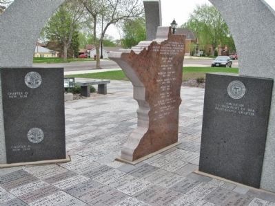
Brown County Veterans Memorial
| On South State Street north of 1st South Street, on the left when traveling north. |
| On South State Street south of Center Street, on the right when traveling south. |
| On Main Street West (U.S. 14) west of 1st Avenue, on the right when traveling west. |
| On East Central Street west of Cass Avenue, on the right when traveling east. |
| Near County Road 24, 0.5 miles east of East End Avenue (County Highway 5), on the right when traveling east. |
| On Veterans Evergreen Memorial Drive (State Highway 23) at Line Road, on the right when traveling south on Veterans Evergreen Memorial Drive. |
| On Lakeview Avenue at 6th Street, on the right when traveling north on Lakeview Avenue. |
| Near Sibley Street near 1st Street, on the left when traveling north. |
| Near 1st Street at Ramsey Street. |
| Near Pilot Knob Road (County Road 31) at Acacia Boulevard. |
| On 1st Ave E near Viking Trail (State Highway 27), on the right when traveling south. |
| On Main Street (U.S. 61) at West Avenue, on the right when traveling north on Main Street. |
| On Main Street (State Highway 55) at Minnesota Avenue on Main Street. |
| On Lake Street at 2nd Street on Lake Street. |
| On Klanska Drive near Covill Drive. |
| On Shoreline Drive (County Road 15) at Belmont Lane, on the right when traveling east on Shoreline Drive. |
| Near Portland Avenue south of East 64th Street, on the left when traveling south. |
| On Main Street South (State Highway 9) at 1st Avenue Southwest, on the right when traveling south on Main Street South. |
| On Lake Avenue North (County Highway 30) north of Manitoba Street (County Highway 58), on the right when traveling north. |
| Near Business U.S. 71, 0.5 miles north of 10th Street Northeast, on the left when traveling north. |
| Near Business U.S. 71 at Hawaii Street Northeast, on the right when traveling north. |
| On Benton Street east of Grant Street, on the right when traveling east. |
| On 2nd Street North west of 4th Avenue North, on the right when traveling west. |
| On Oak Leaf Road at Desota Avenue South when traveling west on Oak Leaf Road. |
| On Oakland Avenue Southeast, 0.1 miles east of Echo Drive Southeast, on the left when traveling east. |
| On 1st Avenue Northeast at Adams Street Northeast, on the right when traveling west on 1st Avenue Northeast. |
| On Central Avenue (County Highway 109) at Juniper Street South, on the left when traveling west on Central Avenue. |
| On Parker Avenue East (U.S. 12) at Guy Street, on the left when traveling east on Parker Avenue East. |
| On State Street (State Highway 22) north of Meeker Avenue (State Highway 55), on the left when traveling north. |
| On State Highway 24 at milepost 6 at County Highway 2, on the left when traveling north on State Highway 24. |
| On County Highway 27 at 722nd Avenue (County Highway 19), on the right when traveling east on County Highway 27. |
| On South Sibley Avenue (County Highway 22) at South Ripley Drive, on the right when traveling south on South Sibley Avenue. |
| On Veterans Drive west of Central Avenue South (County Highway 2), on the right when traveling west. |
| On Mill Street, 0.2 miles north of 1st Street, on the left when traveling south. |
| On South Minnesota Avenue (State Highway 99) south of West Mulberry Street, on the left when traveling south. |
| On Main Street (County Road 64) at 4th Street, on the left when traveling north on Main Street. |
| Near Harriet Island Road. |
| On Vernon Avenue near 3rd Street. |
| On Reservation Highway 1, 0.2 miles west of County Highway 2, on the right when traveling west. |
| On U.S. 212 at 525th Avenue (County Road 51), on the right when traveling west on U.S. 212. |
| On 2nd Avenue Southeast west of 1st Street Southeast, on the left when traveling west. |
| Near Canal Park Drive/North Shore Scenic Drive south of East Morse Street when traveling south. |
| On West Arrowhead Road at Miller Trunk Highway (U.S. 53) on West Arrowhead Road. |
| Near Dillion Road north of West 41st Street (U.S. 169), on the right when traveling north. |
| On East Church Street east of North Walnut Street (Minnesota Highway 25), on the left when traveling east. |
| On South Ash Street south of East Enterprise Drive, on the left when traveling south. |
| On East Raven Street east of East Enterprise Drive, on the right when traveling east. |
| Near County Highway 101 at Sarazin Street. |
| On North 8th Street north of Fort Road, on the right when traveling north. |
| Near Cemetery Road, 0.9 miles west of Minnesota Highway 23, on the right when traveling west. |
| On West Hills Circle north of Dunnell Drive, on the right when traveling north. |
| On West Frontage Road (County Road 23) 0.8 miles north of 26 Street NW, on the right when traveling south. |
| On West Frontage Road (County Road 23) 0.8 miles north of 26th Street NW, on the right when traveling south. |
| On North Lakeshore Drive (U.S. 61 / 63) at North Park Street, on the right when traveling north on North Lakeshore Drive. |
| On South Lakeshore Drive (U.S. 61) at West Dwelle Street, on the left when traveling south on South Lakeshore Drive. |
| On Pembroke Avenue (State Highway 60) at Hiawatha Drive East (County Road 30), on the left when traveling south on Pembroke Avenue. |
| Near Pine Street West west of Third Street South (County Highway 23), on the right when traveling west. |
| On Lake Park Drive east of Main Street (State Highway 43), on the right when traveling east. |
| On Atlantic Avenue (County Highway 9) west of North 5th Street, on the left when traveling west. |