Big Horn grew up as one of the main communities along the stage route in Sheridan County. The first Big Horn Post Office was established in 1879 at Thomas Creighton's ranch two miles northeast of Big Horn. In 1881, Creighton sold his ranch, and the . . . — — Map (db m91401) HM
Near here emigrants traversed the Bozeman Trail, 1864-68 to Virginia City, Montana gold mines. Confronted with hostile Indians unwilling to share their hunting grounds, the trail became known as the "Bloody Bozeman" and was discontinued. . . . — — Map (db m91423) HM
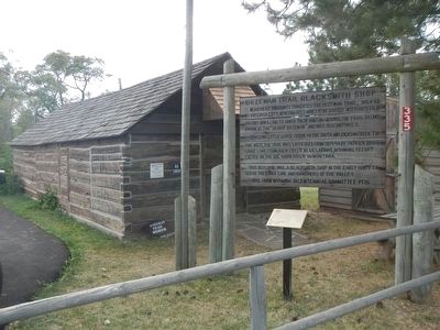
During the 1880s, as Sheridan County was settled and railroads steadily advanced through Wyoming, stagecoach operations changed from long-distance interstate service between railheads to a network of shorter routes connecting rail terminal and . . . — — Map (db m91425) HM
Pass Post Office was established alongside the stage road in 1888 by Thurston W. Akins on his homestead on Twin Creek, five and a half miles northwest of Ohlman and three quarters of a mile south of the Wyoming-Montana line. The post office served . . . — — Map (db m91426) HM
Historically, this area of the Tongue River served as a trail and stage road crossing. The Boseman Trail, road to the Montana gold fields, crossed here beginning in 1864. The Bozeman cut through the Powder River Basin, violating the Fort . . . — — Map (db m86276) HM
Beginning in July 1878 the U.S. Postal Service awarded contracts to stage lines to operated mail and passenger service on start route 37110 between Rock Creek, on the Union Pacific Railroad in southeastern Wyoming, and Northern Pacific Railroad . . . — — Map (db m91430) HM
If you were here in the late 1860's, this quiet setting would be alive with noises from livestock, people, wagons, and water. As you continue along the trail, imagine sights and sounds of busy emigrants crossing the river and camping here.
A . . . — — Map (db m96869) HM
With an abundant supply of water, grass, and wood, many emigrants camped at least one night at the New Fork River. Laying over allowed emigrants to catch up on chores, rest and even play.
We busy ourselves in various ways - some get a fine . . . — — Map (db m100363) HM
The Lander Trail, part of the Congressionally designated California National Historic Trail, was a shortcut of the main emigrant trails to California and Oregon, as well as to the new gold fields in Montana and Idaho. Emigrants started their . . . — — Map (db m96954) HM
The swale (small trench) running left to right in front of you is a remnant of the old Lander Trail. It is unknown if this swale formed by repeated wagon use or during trail construction. Unlike all previous western emigrant trails - which evolved . . . — — Map (db m96874) HM
Frederick Lander carefully chose this place for the trail to cross the New Fork River. An island once split the river in two channels, allowing emigrants to ford without a bridge or ferry.
There is a large island in the centre (sic), and the . . . — — Map (db m96872) HM
In April 1862 the Thomas Paul family left Fremont, Iowa, for Washington Territory. Mrs. Elizabeth Mortimore Paul, who was pregnant, had a difficult time on the journey west, and here on July 27, 1862, age 32, she died giving birth to a daughter. . . . — — Map (db m179898) HM
In 1859 during the first year of use, over 13,000 emigrants and 19,000 head of stock passed along the Lander Cut-Off. This area known as LaBarge Meadows was a favorite resting place of the pioneers. The abundant grass provided forage for the large . . . — — Map (db m179895) HM
At this point the pioneers began their ascent of the mountains, having traveled 106 miles since leaving the main road. The graves nearby are those of emigrants left behind as a result of hardships, accidents and disease. Death was a frequent visitor . . . — — Map (db m180088) HM
In about 1890 an immigrant wagon tipped over at this crossing, A small girl was drowned and was buried in this vicinity. The exact location of garage is unknown. — — Map (db m179902) HM
The Lander Road or "Trail" crosses the New Fork River just beyond this sign. Here, the river was shallow enough to allow emigrant wagons to ford the river without aid of a ferry. The good water, livestock feed, and firewood made this a popular . . . — — Map (db m180093) HM
The water runoff from nearby mountains changes seasonally and from year to year. Emigrants used a variety of methods for crossing, depending on how much water flowed in the New Fork River.
Fording the New Fork: Low Water Crossing . . . — — Map (db m96871) HM
The Lander Cut-Off of the Oregon Trail was constructed in 1858. It was the first federally funded road west of the Mississippi River. After leaving the original Oregon Trail near South Pass, the Lander Cut-Off crossed this mountainous region and . . . — — Map (db m180089) HM
Livestock outnumbered emigrants five to one on the Lander Trail. A typical emigrant wagon needed four mules or 4-6 oxen to pull a wagon with up to 2,000 pounds of supplies. Emigrants also brought riding horses, milk cows, beef cattle, and even . . . — — Map (db m100366) HM
This maker consists of three plaques, each dealing with the Lander Cut-off.
“The Best Mountain Road in the West”
In 1857, Congress funded construction of the Fort Kearney-South Pass-Honey Lakes Wagon Road (Lander . . . — — Map (db m80540) HM
The place where this road crosses the Big Sandy River, to your left, is known as Buckskin Crossing. This has been a campsite and river ford for hundreds if not thousands of years, part of the ancient trail system linking South Pass to the Upper . . . — — Map (db m96718) HM
This site is a crossing of the Lander Cut-off, the northern fork of the Oregon Trail. Originally called the Fort Kearney-South Pass-Honey Lake Wagon Road when it opened in 1858, it was the first federally-funded road project west of the Mississippi . . . — — Map (db m47092) HM
Route of Lander cut-off first government financed road in Wyoming. Officially called Ft. Kearney, South Pass and Honey Lake Road. Built in 1858 from Rocky Ridge to Ft. Hall to provide shorter route for emigrants. — — Map (db m47093) HM
This marks a fork in the trail, right to Oregon, left to Utah and California.
1812, Robert Stuart and eastbound Astorians used South Pass gateway.
1824, Eleven westbound Ashley-Henry men led by Jedediah Smith and Thomas Fitzpatrick.
. . . — — Map (db m67035) HM
This point on the trail is called the Parting-of-the-Ways. The trail to the right is the Sublette or Greenwood Cutoff and to the left is the main route of the Oregon, Mormon, and California Trails. The Sublette Cutoff was opened in 1844 because it . . . — — Map (db m96684) HM
Trail ruts at this site were mistakenly identified as the Parting-of-the-Ways where emigrant parties separated on their journeys to Oregon, California, or Utah.
The actual Parting-of-the-Ways is approximately 10 miles west of this spot. . . . — — Map (db m237433) HM
In July 1844 the California bound Stevens-Townsend-Murphy wagon train, guided by Isaac Hitchcock and 81-year old Caleb Greenwood, passed this point and continued nine and one half miles southwest from here, to a place destined to become prominent . . . — — Map (db m67036) HM
For more than than one hundred years, the Green River Drift cattle trail has connected the seasonal communal grazing lands to cattle ranches in the Upper Green River Valley. The trail is used by area ranchers to move livestock, using cowboys on . . . — — Map (db m180301) HM
Graves were an all-to-frequent reminder of the dangers of overland travel. Most emigrant journals record death, burial, or passing graves during the day's travel. Most burials along the trail were hasty affairs.
The official Company Journal of . . . — — Map (db m67045) HM
Death on the trail did not allow for the fineries of the funerals back home. Emigrants made do with materials available. Black would adorn the clothes of mourners, and care would be taken to provide the best funeral possible. The most travelers . . . — — Map (db m67044) HM
Just a few miles from where you're standing, the emigrants would come to the first of several trail "splits" that would take them to a crossing on the Green River where they would camp for the evening.
Even with South Pass behind them, Oregon . . . — — Map (db m67043) HM
Crossing rivers was the most dangerous activity emigrants faced on their journey west. By the time weary pioneers enroute (sic) to Oregon, California, or Utah reached the east bank of the Green River, they had been on the trail for several months. . . . — — Map (db m90015) HM
Death was a constant companion for emigrants headed west. It is estimated that 10,000 to 30,000 people died and were buried along the trails between 1843 and 1869.
Cholera and other diseases were the most common cause of death. People didn't . . . — — Map (db m67046) HM
Relations between emigrants using the trails and the Indians were inconsistent during the migration period. While hostile acts and violent confrontation did occur, they have been overemphasized in trail history. During the early migration period of . . . — — Map (db m67049) HM
If you look down the river about 250 yards on the right side - there's a wooden ferry. The ferry you see was built by Forrest Cramer of Pinedale, Wyoming in 1997 of the 150th anniversary celebrations of the Mormon Pioneer National Historic Trail. . . . — — Map (db m88481) HM
This spot where the old Oregon and Mormon Trails cross the Little Sandy River (or Creek) was a popular camping and resting place for travelers headed to Oregon, California and Utah. Indeed, this site is one of the most significant landmarks on the . . . — — Map (db m96697) HM
For the hundreds of people heading west, life was one day at a time. The travelers had settled into the monotonous routine of life on the trail - up before dawn, an early breakfast, hitch up the stock, and begin the day's journey.
Upon safely . . . — — Map (db m90035) HM
The emigration of Mormon (Church of Jesus Christ of Latter-dat Saints) converts to Utah is a fascinating chapter of the overall American westering experience of the 19th century. In search of religious freedom and an end to persecution, Mormon . . . — — Map (db m88477) HM
On the horizon about 25 miles to the south is Pilot Butte. An important landmark, Pilot Butte served as a guide post separating South Pass trails from the more southerly Overland Trail that crossed southern Wyoming. Oddly enough, Pilot Butte was . . . — — Map (db m67047) HM
Welcome to the Pilot Butte Emigrant Trails Interpretive Site. The purpose of the site is to help you gain a sense of what life was like for the 400,000 emigrants who left their homes to seek a new life in the West. They were seeking wealth, . . . — — Map (db m67042) HM
This site of the Lombard Ferry was one of the most used crossings on the Green River, lasting from about 1843 into the early 1900s. First established by mountain men, it was operated by Mormons in the 1850s during the peak years of the westward . . . — — Map (db m88473) HM
To All Pioneers
Who Passed
This Way
To Win And Hold
The West
Trail Crossed
30 Miles North
This Point
Erected By
People Of
Green River 1931 — — Map (db m67775) HM
The Overland Stage
Station Route
Operated
1861 — 1868
Green River Division
Station Site
350 Yards East
Erected By
The Historical Landmark
Commission of Wyoming
1952 — — Map (db m67777) HM
At the beginning of the Civil War military strength in the West declined and often it was impossible to safeguard stages carrying the United States mail along the Oregon-California-Mormon Trail. Early in 1862 "Stagecoach King" Ben Holladay . . . — — Map (db m67925) HM
After the Civil War, the Union Pacific laid track westward, bringing commerce to the wilderness. Establishment of the transcontinental railroad and the communities which sprung up around the railroads helped settle the Territory of Wyoming. . . . — — Map (db m73958) HM
Before the Transcontinental Railroad connected the East and West coasts of the United States, stage coach lines transported both passengers and mail across the country. Stations along the route functioned as pit stops, where horses - tired and . . . — — Map (db m76743) HM
On June 6, 1929, the Rock Springs Coal "Welcome" sign was lit. The Union Pacific Coal Company Employes' Magazine reported it spanned the Lincoln Highway and was approximately 100 feet from the main line of the Union Pacific Railroad. It was . . . — — Map (db m67811) HM
This was the original location of the Henry B. Joy Lincoln Highway Monument placed in 1938 following Joy's death. Henry Bourne Joy was president of the Packard Motor Car Company and the first president of the Lincoln Highway Association. The Lincoln . . . — — Map (db m67960) HM
Togwotee (pronounced "TOE-go-tee") Pass lies at the head of the Wind River, astride the Great Divide. This 9,658-foot pass was an ancient travel route for the Tukudika people, who lived among these high, rugged peaks and migrated on foot for . . . — — Map (db m96370) HM
Two markers are found on the trail information panel at the summit of Teton Pass
History
Indian artifacts dating back over 9,000 years have been found in the Teton Pass and Trail Creek areas. These findings are proof of the . . . — — Map (db m90976) HM
Southern Wyoming has served as a major travel corridor since the mid 1800s – and for good reason. Emigrants traveling west needed safe routes where food and water were available. Guides familiar with the region determined the best route was . . . — — Map (db m67756) HM
The Oregon and California Trails came into Uinta County from South Pass, whereas the Overland Trail came through Bridger Pass. In 1845, more than 3,000 emigrant were on the Oregon Trail seeking adventure, fortune or religious freedom.
The . . . — — Map (db m90113) HM
The Lincoln Highway was established in 1913 as the nation's first coast-to-coast automobile route. It consisted of existing roads that were marked with the distinctive Lincoln Highway logo. Perhaps the most famous means of identification was . . . — — Map (db m67739) HM
This crossing was on the historic Mormon Trail. Lands surrounding the crossing were a welcome rest stop for weary pioneers. John Myers ferried emigrants across the Bear River and provided needed supplies from his store.
In 1858, the Myers Ranch, . . . — — Map (db m165966) HM
"At three o'clock p.m. we crossed Muddy Creek, a beautiful clear stream of water with a pebbly bottom, and camped on the west side after traveling 3 miles during the day ... we had a pretty campground... The brethren sang hymns for the President; . . . — — Map (db m36566) HM
The Muddy Creek Camp, which was northwest of this marker and on the west side of the Muddy Creek was used by Brigham Young's first group of Mormon pioneers who arrived here on July 9, 1847. Thomas Bullock reported that the brethren sang . . . — — Map (db m36573) HM
In 1928, the Boy Scouts erected 2,400 of these monuments to commemorate the first Coast to Coast Highway from New York to San Francisco.
We dedicate this monument to the memory of Mr. Albino Fillin of Fort Bridger who though to save it for . . . — — Map (db m90689) HM
On August 3, 1855 the Church of Jesus Christ of Latter-day Saints concluded arrangements for the purchase of Fort Bridge from Louis Vasquez, partner of James Bridger, for $3,000. Final payment was made October 18, 1858. A cobblestone wall was . . . — — Map (db m90617) HM
From the late 1840s through the 1860s, an exodus of more than 70,000 Mormons passed by here on their way to their "New Zion" in Utah. Starting from Nauvoo, Illinois in February 1846, the first group of at least 13,000 Mormons crossed into Iowa to . . . — — Map (db m90583) HM
Erected by
The Members of
the
Woodruff Stake
in Honor of
The Mormon Pioneers
Who passed this point
Wednesday July 7, 1847
and in subsequent years — — Map (db m36620) HM
In 1864 an alternate route to the goldfields of western Montana was needed due to frequent hostile actions along the Bozeman Trail. Though the Civil War raged on, the Nation continued its westward expansion through the efforts of men like Jim . . . — — Map (db m97827) HM
The Cheyenne-Deadwood Trail, a heritage precious to state and nation, was used by gold seekers and Black Hills emigrants from 1876 to 1887. Crossing U. S. Highway 16 at this point, it followed Stockade Beaver Creek passing Beaver Creek Stage . . . — — Map (db m4305) HM
Following the Civil War, construction of the transcontinental Railroad opened the West, ensuring elimination of vast buffalo herds and forcing Native American Indians onto reservations where the military provided food.
Leggy Texas Longhorns were . . . — — Map (db m98249) HM
Following the Civil War, construction of the transcontinental Railroad opened the west, ensuring elimination of the buffalo herds, forcing Native American Indians onto reservations where the military provided food. The rails transported range . . . — — Map (db m98248) HM
277 entries matched your criteria. Entries 201 through 277 are listed above. ⊲ Previous 100