The wreck of the Yaquina City
The steamer Yaquina City was one of the four ships that ran the route between San Francisco and Yaquina City (now a ghost town up the bay).
The ships carried freight (mostly wheat) and passengers.
In . . . — — Map (db m177152) HM
In 1861 word about beds of a rare rock oyster on Yaquina Bay spread to San Francisco. Ships came for the oysters which were served at top restaurants on the west and east coasts. Local Indians, in particular women, were hired to harvest the oysters. . . . — — Map (db m177026) HM
Founded in 1865, Newport has become the largest town on the central Oregon coast.
Its railroad, maritime and highway connections have nurtured its development.
Newport Harbor
Today, Newport's harbor serves mostly . . . — — Map (db m112412) HM
Built by USCG Yard August 30, 1946
Retired from active service April 8, 1970
In memory of those lost at sea, and
to those men whose courage, initiative
and unwavering devotion to duty were
in keeping with the highest traditions
of . . . — — Map (db m113503) HM WM
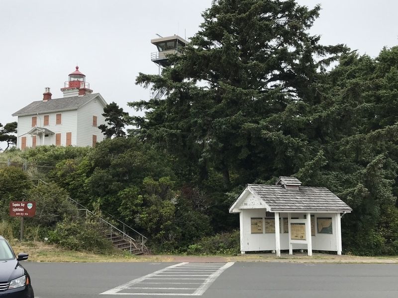
The old Yaquina Bay Lighthouse established in 1871 is the earliest aid to navigation, standing within the range of the first recorded landfall made from a ship to the shores of the Pacific Northwest. Captain James Cook made this landfall on March . . . — — Map (db m113917) HM
(Inside this kiosk are seven panels which deal with the Malheur River and Meek's Cutoff.
"Pathway to the "Garden of the World"
Excitement filled the air May 22, 1843 as nearly one thousand Americans left Missouri . . . — — Map (db m107077) HM
During the period of Oregon's Provisional Government ( 1841-1849), residents traveled by Indian trails, water courses, or on privative rough-hewn wagon roads etched by emigrant settlers. During the days to the Territorial Government (1849-1859), and . . . — — Map (db m114295) HM
Captain George Vancouver in a voyage of exploration to the Northwest coast of America ordered by the British Admiralty Office assigned Lieutenant William Robert Broughton, Commander of H.M.S. Chatham, to explore the navigable waters of the Columbia . . . — — Map (db m34495) HM
There is much of legend and tradition associated with the Columbia River and its gorge.
The geologic story is neither fable, myth nor tradition, but one of fact, facts that independently stand out in every rock and waterfall, as if begging . . . — — Map (db m114529) HM
Meriwether Lewis and William Clark, the two great American explores who made secure claim of the United States for the Oregon Country, passed along this stretch of the Columbia River with their Corp of Discovery on their way to the Pacific Ocean on . . . — — Map (db m158543) HM
Originator of ocean going log rafts. Sponsor of the Columbia River Highway. Benefactor of Benson Polytechnic School. Donor of the Benson Tract containing Multnomah Falls, Wahkeena Falls and Benson State Park.
Patern and casting by Benson High . . . — — Map (db m91212) HM
600 yards southwest on the east bank of the Multnomah Channel was the site of Fort William. Nathaniel J. Wyeh, Massachusetts trader and founder of Ft. Hall, established Ft. William near Warrior Point in 1834. In the spring of 1835 he moved the . . . — — Map (db m245463) HM
In Remembrance of the United States Battleship Oregon
(Commissioned July 1896)
and Her Officers and men.
During the Spanish American War this battleship won the admiration of the whole world in her dramatic dash from San Francisco to Key . . . — — Map (db m241332) HM WM
The Oregon Trail crossed the hazardous Deschutes River at this point by floating the prairie schooners and swimming the livestock. An island at the river mouth was often utilized when the water was high and the ford dangerous. Pioneer women and . . . — — Map (db m34575) HM
commanding the sloop, "Lady Washington" left Boston in October 1787 on a trading voyage to the West Coast of North America, seeking otter furs. To his small crew of about a dozen men, Gray soon added Markus Lopeus, who boarded at the Cape Verde . . . — — Map (db m113549) HM
Captain Robert Gray was born in Tiverton, Rhode Island, 10 May 1755. Little is known of his youth. During the American Revolution and our war with the French (1798-1801) Captain Gray commanded Letter of Marque vessels. She was Alert, another was . . . — — Map (db m203041) HM
If sight of sand and sky and sea has given respite from your daily cares then pause to thank Oswald West former governor of Oregon (1911-1915) By his foresight nearly 400 miles of the ocean shore was set aside for public use, from the . . . — — Map (db m113784) HM
Neahkahnie Mountain has been the subject of stories and legends for hundred of years. From Spanish galleons to buried treasure, the Mountain resonates with mystery and romance. How many of these stories are true? What do you think?
The Beeswax . . . — — Map (db m113733) HM
The French hand-ground Fresnel lens at Cape Meares is one of only two eight-sided lights in the United States – the other is in Hawaii. Keepers were given detailed instructions for maintaining the masterpiece.
A brilliant . . . — — Map (db m113918) HM
As they passed Hat Rock, the explorers were just beginning the most exciting phase of their journey... reaching their goal. .
The Corps of Discovery had endured months of hardship, especially the bitter cold and hunger in the seemingly . . . — — Map (db m158689) HM
In 1804-06, Captains Meriwether Lewis and William Clark led about 40 soldiers and boatmen on an epic journey. President Thomas Jefferson commissioned this "Corps of Discovery" to find a route to the Pacific Ocean through the newly acquired . . . — — Map (db m114092) HM
The Corps of Discovery descended the Columbia River in five dugout canoes made from pines felled at the mouth of the North Fork of the Clearwater River in Idaho.
Before McNary Dam harnessed this segment of the mighty Columbia, the river plunged . . . — — Map (db m114089) HM
The Indian Peoples of the Columbia River did not bury their dead until very recent times.
Instead, bodies were wrapped in robes or tule mats and deposited in canoes which were placed in the woods, on rocky points, or in cedar vaults on islands . . . — — Map (db m112253) HM
Glaciers form when snow accumulates faster than it melts over a long period and is compressed into ice.
Eventually, the weight and pressure become so great that the ice oozes slowly downslope.
Volcanism, uplift, erosion, and human . . . — — Map (db m112249) HM
Today, engineers use high resolution satellite photography and advanced computer modeling software to design roads.
Gazing down upon the graceful, winding Historic Columbia River Highway, it is easy to forget how challenging its . . . — — Map (db m112250) HM
In Commemoration of
the Celilo Falls Fishing Grounds
Historic fishing trading and gathering place for Indians of many Tribes from time immemorial until inundated by the rising waters of
Lake Celilo in March 1957 — — Map (db m111983) HM
From 1841 until the early 1900's more than 500,000 people traveled over 2,000 miles from Independence, Missouri to The Dalles, Oregon. They had to make a decision at The Dalles for traveling the last 100 miles to the Willamette Valley. They could . . . — — Map (db m112468) HM
Before The Dalles Dam was built, the Columbia River plunged over Celilo Falls and cut through the Narrows or Five Mile Rapids. Although obstacles to navigation, the falls created the region’s greatest fishing site. For more than 10,000 years . . . — — Map (db m111985) HM
The British owned Hudson Bay Company dominated the fur trade in the Pacific Northwest during the early 1800's.
Dr. John McLaughlin, who headed the Northwest enterprise, sent brigades of boats far up the Columbia River to the far flung company . . . — — Map (db m114142) HM
"...at three in the evening we arrived at the entrance to Quinnette creek (known today as Mill Creek) which we ascended a short distance and encamped at the place we have called rock fort camp." - Meriwether Lewis, April 13, 1806 . . . — — Map (db m158415) HM
130 entries matched your criteria. Entries 101 through 130 are listed above. ⊲ Previous 100