Marker Logo HMdb.org THE HISTORICAL
MARKER DATABASE
“Bite-Size Bits of Local, National, and Global History”


After filtering for Kansas, 136 entries match your criteria. The first 100 are listed.                                               The final 36 


Notable Buildings Topic

 
Democratic Headquarters Marker image, Touch for more information
By Mike Wintermantel, June 21, 2018
Democratic Headquarters Marker
1 Kansas, Douglas County, Lecompton — Democratic Headquarters
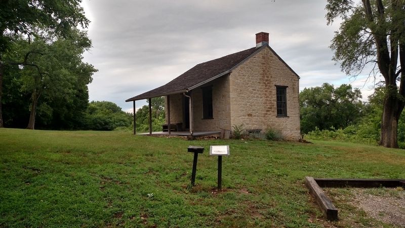
On East Second Street, 0.1 miles east of Haldeman Street, on the right when traveling west.
This stone building was the headquarters of the Democratic Party during the Kansas Territorial period (1854-61). The cabin was used during a time when Lecompton, known as "The Birthplace of the Kansas Democratic Party,” was the territorial . . . Map (db m162724) HM
2 Kansas, Finney County, Garden City — The Little Finnup House — Circa 1886
On 9th Street at Pine Street, on the left when traveling north on 9th Street.
This property has been placed on the National Register of Historic Places by the United States Department of the InteriorMap (db m65856) HM
3 Kansas, Franklin County, Wellsville — Wellsville's First Brick Building — 1885
On Main Street north of 5th Street, on the left when traveling north.
[Title is marker text]Map (db m63700) HM
4 Kansas, Geary County, Fort Riley, Camp Whitside — 24 — First Capitol of Kansas
On Huebner Road east of 10th Street, on the right when traveling east.
This building was erected in 1855 in the now extinct town of Pawnee for the first legislature of the territory of Kansas. The members were mostly Missourians, fraudulently elected in an effort to make Kansas a slave state. They came in wagons and on . . . Map (db m33038) HM
5 Kansas, Grant County, Ulysses — Grant County Shop (Adobe) Building
On Oklahoma Avenue (U.S. 160) at Grant Street, on the left when traveling east on Oklahoma Avenue.
. . . Map (db m65724) HM
6 Kansas, Gray County, Cimarron — Cimarron Hotel — Circa 1886
On Main Street (State Highway 23) at Kansas Avenue, on the left when traveling north on Main Street.
This property has been placed on the National Register of Historic Places by the United States Department of the InteriorMap (db m65472) HM
7 Kansas, Greenwood County, Eureka — Christian and Congregational Church Building
On 3rd Street east of Main Street, on the right when traveling east.
Erected and dedicated 1888, was designated as a Kansas Historical Site, May 26, 1989, by the Kansas State Historical Society.Map (db m76361) HM
8 Kansas, Harvey County, Newton — Railroad Savings and Loan Building — 1925
On Main Street at 5th Street, on the right when traveling north on Main Street.
This property has been placed on the National Register of Historic Places by the United States Department of the InteriorMap (db m53503) HM
Paid Advertisement
9 Kansas, Jefferson County, Oskaloosa — 3 — Winchester Jail
On Walnut Street (U.S. 59) 0.2 miles north of Lawrence Street, on the right when traveling north.
The jail building was relocated from Winchester to Old JeffersonTown in 1977. The Winchester town police were more likely to use the jail as a sleep-over from drunks [than] to contain a criminal. It also served as a meeting place for city . . . Map (db m63748) HM
10 Kansas, Johnson County, Merriam — Campbell Home — First Home In Merriam
On Johnson County, 0.1 miles west of Campbell Street, on the left.
In 1864 David Gee Campbell finally found his safe haven at this site, after dodging threats from the Missourians and danger from Quantrill's raiders in Shawnee. This valley reminded Campbell of his Tennessee home and his Scottish roots. . . . Map (db m51344) HM
11 Kansas, Johnson County, Olathe — A Survivor
This barn is thought to be the oldest structure standing on the Mahaffie farm. While the siding was replaced at least twice, the frame underneath probably dates to about 1860, when the Mahaffies established the farm and their first home. In 2009, . . . Map (db m34542) HM
12 Kansas, Johnson County, Overland Park — A. M. Wood Buildings
On Foster Street south of 80th Street, on the right when traveling south.
Built 1923Map (db m69335) HM
13 Kansas, Johnson County, Overland Park — Conser Garage & Bus Station
On Santa Fe Trail Drive north of 80th Street, on the left when traveling north.
Built 1928Map (db m69330) HM
14 Kansas, Johnson County, Overland Park — Conser Store & Hall
On 80th Street at Foster Street, on the right when traveling west on 80th Street.
Built 1911 A landmark building designated by the O. P. Landmark CommissionMap (db m69339) HM
15 Kansas, Johnson County, Overland Park — Hedrick-Fleming Hall & Post Office — Built 1925
On 80th Street, 0.2 miles west of Metcalf Avenue, on the left when traveling west.
[Title is text]Map (db m99278) HM
16 Kansas, Johnson County, Overland Park — Overland Park State Bank Building — Built 1910
On 80th Street at Overland Park Drive, on the left when traveling west on 80th Street.
A landmark building designated by the O.P. Landmark CommissionMap (db m99279) HM
17 Kansas, Johnson County, Overland Park — Stanley Rural High School — 1919 - 1965
On Metcalf Avenue, on the right.
While S.R.H.S. was being built, classes were held in the Christian and Methodist churches - Grange Hall. Charter Roll SCHOOL BOARD      TEACHERS J.L. Chaney, R.H. Holmes, P.L. Kellogg - J.L. Stark, Principal; Amy Kincaid . . . Map (db m20786) HM
Paid Advertisement
18 Kansas, Johnson County, Overland Park — Voights Building
On 80th Street at Santa Fe Trail Drive, on the right when traveling west on 80th Street.
Built 1928Map (db m69331) HM
19 Kansas, Johnson County, Overland Park — Wilson-Weldon Buildings
On Foster Street at Santa Fe Trail Drive, on the right when traveling south on Foster Street.
Built 1924Map (db m69337) HM
20 Kansas, Kearny County, Lakin — The White House
On Buffalo Street south of Waterman Avenue, on the right when traveling south.
Built and owned by Alonzo B. Boylan 1876 - 1890Map (db m65751) HM
21 Kansas, Kingman County, Kingman — Carnegie Library
On Main Street (State Highway 14) at D Avenue (U.S. 54/400), on the left when traveling north on Main Street.
This property has been placed on the National Register of Historic Places by the United States Department of the InteriorMap (db m62636) HM
22 Kansas, Kingman County, Kingman — City Building
On C Avenue at Main Street (Kansas Highway 14), on the left when traveling east on C Avenue.
This property has been placed on the National Register of Historic Places by the United States Department of the InteriorMap (db m62656) HM
23 Kansas, Kingman County, Kingman — Kingman County Courthouse
On Spruce Street north of Sherman Street, on the right when traveling north.
This property has been placed on the National Register of Historic Places by the United States Department of the InteriorMap (db m62693) HM
24 Kansas, Kingman County, Kingman — Kingman Memorial Armory — Company L 137th Infantry — 1937 —
On Main Street (State Highway 14) north of 1st Street, on the left when traveling north.
This property has been placed on the National Register of Historic Places by the United States Department of the InteriorMap (db m62696) HM
25 Kansas, Kingman County, Kingman — United States Post Office
On Main Street (State Highway 14) north of C Avenue, on the left when traveling north.
This property has been placed on the National Register of Historic Places by the United States Department of the InteriorMap (db m62655) HM
26 Kansas, Labette County, Edna — First State Bank
On Delaware Street (State Highway 101) at Main Street, on the left when traveling north on Delaware Street.
This property has been placed on the National Register of Historic Places by the United States Department of the InteriorMap (db m60793) HM
Paid Advertisement
27 Kansas, Leavenworth County, Leavenworth — "Harvey House" Leavenworth Court House Annex I — Established 1984
On Olive Street at 7th Street, on the right when traveling west on Olive Street.
This home was built circa 1870 by A. A. Higgenbotham. The stone was quarried at Junction City, Kansas. Messrs. Anthony, Goehner and Lysle negotiated with the Harvey family and the property was donated to Cushing Hospital in 1944. The Hospital . . . Map (db m53605) HM
28 Kansas, Leavenworth County, Leavenworth — Riverfront Community Center — Old Union Depot — Built in 1888 by James A. McGonigle —
On Esplanade Street at Delaware Street, on the left when traveling south on Esplanade Street.
In 1984 V.B. Greenamyre and family gave the building to the City of Leavenworth. In 1985 a bond issue was voted to renovate the building and to build additional facilities. A half cent sales tax was approved to payoff those bonds and support the . . . Map (db m42110) HM
29 Kansas, Leavenworth County, Leavenworth — The Carroll House — Leavenworth Historical Museum
On 5th Avenue at Middle Street, on the right when traveling north on 5th Avenue.
In the early 1860's John Foster bought the farm land and house which is now Leavenworth's Museum. The farm was transferred to Lucien Scott a banker in 1882. Mr. Scott added the front part to the house and his architect George McKenna carved the . . . Map (db m82715) HM
30 Kansas, Leavenworth County, Leavenworth — The Knapp House
On 7th Street at Olive Street, on the right when traveling south on 7th Street.
Built in 1894 by Chauncey L. Knapp, founder & owner of C.L. Knapp & Co. 418 DelawareMap (db m53569) HM
31 Kansas, Lincoln County, Lincoln — Lincoln County Courthouse
On East Lincoln Avenue just east of North 3rd Street, on the left when traveling east.
has been placed on the National Register of Historic Places by the United States Department of the Interior 1899Map (db m204683) HM
32 Kansas, Linn County, Prescott — Prescott Rural High School — 1924
On West 4th Street at Main Street, on the right when traveling south on West 4th Street.
This property has been placed on the National Register of Historic Places by the United States Department of the InteriorMap (db m64662) HM
33 Kansas, Linn County, Prescott — Prescott School — 1883
On West 3rd Street at Main Street, on the right when traveling south on West 3rd Street.
This property has been placed on the National Register of Historic Places by the United States Department of the InteriorMap (db m64659) HM
34 Kansas, Lyon County, Emporia — Kress Building
On Commercial Street (State Highway 99) at 7th Avenue, on the right when traveling north on Commercial Street.
This property has been placed on the National Register of Historic Places by the United States Department of the Interior Circa 1929Map (db m49777) HM
35 Kansas, Lyon County, Emporia — Mrs. Preston B. Plumb House
On 6th Avenue (U.S. 50) at Union Street, on the left when traveling east on 6th Avenue.
This house built 1894 by widow of Preston B. Plumb a founder of Emporia. Later given to Emporia Y.W.C.A. by daughters Mary, Ruth, Caroline. —————— Senator Preston B. Plumb and Carrie S. Plumb . . . Map (db m60946) HM
Paid Advertisement
36 Kansas, Lyon County, Emporia — Richard Howe House
On Logan Avenue, on the right when traveling east.
This property has been placed on the National Register of Historic Places by the United States Department of the Interior Circa 1867Map (db m49806) HM
37 Kansas, Marion County, Marion — Elgin House
On 3rd Street at Santa Fe Street, on the left when traveling north on 3rd Street.
This property has been placed on the National Register of Historic Places by the United States Department of the Interior In grateful memory of Van Keith Anderson Nov. 4, 1921 - Jan. 11, 1986 the engineer who developed . . . Map (db m60955) HM
38 Kansas, Marion County, Peabody — Carnegie Library
On Walnut Street at Division Avenue, on the right when traveling north on Walnut Street.
This property is listed in the National Register of Historic Places by the United States Department of the InteriorMap (db m95248) HM
39 Kansas, Marion County, Peabody — J. S. Schroeder Building — Built 1884
On Walnut Street north of 1st Street, on the left when traveling north.
National Register of Historic placesMap (db m95253) HM
40 Kansas, Marshall County, Blue Rapids — Blue Rapids Public Library — 1874
On Main Street at Penny Street, on the right when traveling north on Main Street.
Entered on the National Register of Historic Places March 17, 1972Map (db m78929) HM
41 Kansas, Marshall County, Frankfort — Frankfort Grade School — 1902
On Locust Street (Road to Oz Highway) (State Highway 9) at 4th Street, on the left when traveling north on Locust Street (Road to Oz Highway).
Entered on the National Register of Historic Places Dec. 27, 1972Map (db m79120) HM
42 Kansas, Marshall County, Marysville — Marshall County Court House — 1891
On Broadway near 13th Street, on the right when traveling east.
Entered on the National Register of Historic Places Nov. 5, 1974Map (db m48601) HM
43 Kansas, McPherson County, Lindsborg — Bernquist & Nelson Drugstore — Circa 1880
On Main Street north of Lincoln Street, on the left when traveling north.
was placed on the Register of Historic Kansas Places and the National Register of Historic Places on August 22, 2009Map (db m80606) HM
44 Kansas, McPherson County, Lindsborg — Clareen & Peterson Restaurant — Built In 1899
On Main Street north of Lincoln Street, on the left when traveling north.
was placed on the Register of Historic Kansas Places and the National Register of Historic Places on August 22, 2009Map (db m66645) HM
Paid Advertisement
45 Kansas, McPherson County, Lindsborg — Den Svenska Timmerstugan — The Swedish Timber Cottage
On 2nd Street near State Street, on the left when traveling north.
This traditional Swedish cottage was designed and pre-built in Siljansnδs Sweden and reassembled here in August 1983Map (db m53562) HM
46 Kansas, McPherson County, Lindsborg — Hjerpe Grocery — Built In 1915 and 1930
On Main Street north of Lincoln Street, on the right when traveling north.
was placed on the Register of Historic Kansas Places and the National Register of Historic Places on August 31, 2010Map (db m66646) HM
47 Kansas, McPherson County, Lindsborg — Holmberg and Johnson Blacksmith & Wagonshop — Circa 1900
On Main Street north of Lincoln Street, on the right when traveling north.
was placed on the Register of Historic Kansas Places and the National Register of Historic Places on August 22, 2009Map (db m66647) HM
48 Kansas, McPherson County, Lindsborg — Lindsborg Post Office — Built in 1936
On Lincoln Street at 2nd Street, on the left when traveling east on Lincoln Street.
has been placed on the National Register of Historic Places by the United States Department of the InteriorMap (db m53559) HM
49 Kansas, McPherson County, Lindsborg — The Farmers State Bank Building — Circa 1887
On Main Street at Lincoln Street, on the left when traveling south on Main Street.
has been placed on the National Register of Historic Places by the United States Department of the InteriorMap (db m80605) HM
50 Kansas, McPherson County, Lindsborg — The Teichgraeber-Runbeck House
On Mill Street west of 1st Street, on the left when traveling west.
Built 1906 has been placed on the National Register of Historic Places by the United States Department of the Interior Reg.[istered] 11-15-2005Map (db m80658) HM
51 Kansas, McPherson County, Marquette — Hans Hanson House — Built in 1888
On 5th Street east of Swedonia, on the left when traveling east.
has been placed on the National Register of Historic Places by the United States Department of the Interior 11-11-95Map (db m81761) HM
52 Kansas, McPherson County, Marquette — Opera Block — Built 1886 - 1887
On Washington Street at 2nd Street, on the right when traveling north on Washington Street.
1st brick building in MarquetteMap (db m95297) HM
53 Kansas, McPherson County, McPherson — McPherson Opera House — Built c. 1888
On Main Street (Business U.S. 81) at Sutherland Street, on the left when traveling south on Main Street.
has been placed on the National Register of Historic Places by the United States Department of the Interior Reg.[istered] 3-17-1972Map (db m80664) HM
Paid Advertisement
54 Kansas, Miami County, Osawatomie — Original Land Office — 1854 Centennial 1954
On 6th Street at Lincoln Avenue, on the right when traveling north on 6th Street.
of H. B. Smith, First Mayor Given to the Osawatomie Historical Society in memory of Mrs. A. W. Youngberg by her husbandMap (db m69328) HM
55 Kansas, Mitchell County, Beloit — Mitchell County Courthouse
On East Main Street at South Hersey Avenue (Kansas Route 14), on the left when traveling west on East Main Street.
This property has been placed on the National Register of Historic Places by the United States Department of the InteriorMap (db m131542) HM
56 Kansas, Mitchell County, Beloit — The Porter Hotel
On East Main Street east of North Hersey Avenue (State Highway 14), on the left when traveling east.
is listed in the National Register of Historic Places by the United States Department of the Interior July 23, 2004Map (db m212949) HM
57 Kansas, Montgomery County, Cherryvale — Carnegie Free Library
On Main Street at Montgomery Street, on the right when traveling east on Main Street.
Entered as a National Historic Place August 1987Map (db m61432) HM
58 Kansas, Montgomery County, Coffeyville — Perkins Building — Built 1890
On Walnut Street south of 8th Street, on the left when traveling south.
This building was the location of the C.M. Condon & Company Bank during the time of the infamous raid by the Dalton Gang on the Condon & First National Banks October 5, 1892 Placed on National Register of Historic Places by . . . Map (db m60799) HM
59 Kansas, Morris County, Council Grove — Council Grove National Bank Building — 1887 — Philomathian Heritage Plaque —
On Main Street (U.S. 56) at Neosho Street (Kansas Highway 177), on the right when traveling west on Main Street.
The Council Grove National Bank began August 23, 1878, as the Morris County State Bank of Kansas. It became a national bank in 1900. An 1886 fire destroyed the bank, then located between the Hays House and this building. Constructed in 1887 at a . . . Map (db m45092) HM
60 Kansas, Morris County, Council Grove — Farmers & Drovers Bank — 1893 — Philomathian Heritage Plaque —
On Main Street (U.S. 56) at Neosho Street (Kansas Highway 177), on the left when traveling west on Main Street.
Constructed by F. Roussillet, contractor, this building is an electic [sic] style two story brick with limestone Romanesque arches over half round stained glass windows, marble columns and a Bysantine [sic] dome. The adjacent business building was . . . Map (db m45090) HM
61 Kansas, Nemaha County, Seneca — City Hall
On Main Street at 6th Street, on the right when traveling west on Main Street.
Seneca’s City Hall was built on the site of the charming but combustible wooden firehouse. Completed in 1916 this Beaux Arts style building housed all City and County Offices, as well as the town library, and the police and fire departments. . . . Map (db m55822) HM
62 Kansas, Neosho County, Chanute — The Tioga Inn
On Lincoln Street at Main Street, on the left when traveling north on Lincoln Street.
This property has been placed on the National Register of Historic Places by the United States Department of the InteriorMap (db m57302) HM
Paid Advertisement
63 Kansas, Ness County, Ness City — Lion Block
On Main Street west of Kansas Avenue, on the right when traveling west.
has been listed on the Register of Historic Kansas Places by the United States Department of the Interior August 20, 2008 This property has been listed on the National Register of Historic Places by the United States . . . Map (db m66164) HM
64 Kansas, Ness County, Ness City — Ness County Courthouse
On Sycamore Street at Kansas Avenue, on the right when traveling west on Sycamore Street.
[List of County Officials] [County] Population 1500 [on] date of organization 1880 On day of dedication 7225 [County] Valuation $204,597.00 [on] date of organization 1880 On day of dedication $14,302,982.00 Ross Calhoun Donor of . . . Map (db m66144) HM
65 Kansas, Osborne County, Osborne — Osborne County Courthouse — Built 1906-1908
On Main Street at 4th Street, on the left when traveling west on Main Street.
has been placed on the National Register of Historic Places by the United States Department of the Interior 2001Map (db m53541) HM
66 Kansas, Pottawatomie County, Wamego — Old Dutch Mill
On 4th Street east of Ash Street, on the left when traveling east.
Built in 1879 twelve miles north of Wamego by a Dutch immigrant, this old mill was used to grind grain into flour and cornmeal. In 1925 thirty-five team and wagons moved the mill to Wamego. Each stone was taken down numbered and rebuilt exactly as . . . Map (db m32604) HM
67 Kansas, Reno County, Hutchinson — Bussinger Clothiers — 127 North Main — 1886 —
On Main Street at 2nd Avenue, on the left when traveling north on Main Street.
Altered 1960, rehabilitated 1991. Housed Bussinger Clothiers, Hoagland Clothing, Watson's Clothing and other offices and a boarding house.Map (db m40070) HM
68 Kansas, Reno County, Hutchinson — Citizens Bank — 200 North Main — 1886 —
On Main Street at 2nd Avenue, on the right on Main Street.
Since its original construction, the Highley or Sidlinger Block has always housed a bank or other financial institution.Map (db m40079) HM
69 Kansas, Reno County, Hutchinson — European Hotel — 123 North Main — 1888 —
On Main Street near 2nd Avenue, on the left when traveling north.
Facade added 1925. The European Hotel was listed in 1909 as occupying the upper level.Map (db m40069) HM
70 Kansas, Reno County, Hutchinson — Hutchinson's Historic Fox Theatre
On 1st Avenue, on the left when traveling east.
has been placed on the National Register of Historic Places by the United States Department of the Interior Est. 1931Map (db m40064) HM
71 Kansas, Reno County, Hutchinson — Krous Building — 122 North Main — 1905 —
On Main Street near 2nd Avenue, on the right when traveling north.
Replaced original 1899 Krous Building, altered 1960, rehabilitated 1988. Housed Jenkins & Sons Music, Jones O'Neal Shoes and now Payton Optical.Map (db m40081) HM
Paid Advertisement
72 Kansas, Reno County, Hutchinson — Reno House — 101 North Main — 1871 —
On Main Street at 1st Avenue, on the left when traveling north on Main Street.
Site of the first building solely a hotel, the 1871 Reno Hotel was replaced in 1912 by the Reno House. The American National Bank Building became Hutchinson National Bank.Map (db m40041) HM
73 Kansas, Reno County, Hutchinson — Stallman Block — 119 North Main — 1889 —
On Main Street, on the left when traveling north.
This building has housed Star Clothiers, Nussbaum's and Meschkes Men's Clothing.Map (db m40067) HM
74 Kansas, Reno County, Hutchinson — Strand Theater — 103 North Main — 1913 —
On Main Street near 1st Avenue, on the left when traveling north.
The Strand Theater occupied this site in 1913. It later was called the Deluxe Theater.Map (db m40044) HM
75 Kansas, Reno County, Hutchinson — Whiteside Building — 126 North Main — 1904 —
On Main Street at 2nd Avenue, on the right when traveling north on Main Street.
An early skylight drew Morton Interiors, McInturff Photo Studio and Three Sisters Clothing Store. Site originally was a livery stable.Map (db m40076) HM
76 Kansas, Reno County, Hutchinson — Wiley Building — 100-102 North Main — 1912 —
On Main Street at 1st Avenue, on the right when traveling north on Main Street.
1882 Opera House preceded Vernon Wiley's $350,000, 1912 Classical Revival style skyscraper, tallest building west of the Mississippi, home of Hutchinson Board of Trade and Wiley's Department Store.Map (db m40058) HM
77 Kansas, Rice County, Sterling — The Monroe Apartments
On Monroe Street west of Broadway (Kansas Highway 14/96), on the right when traveling west.
T.H. Brown, owner of the Citizens State Bank, built this office building with the unusual arched doorways in 1900. It had upstairs apartments and also housed such businesses as Hockaday Broom Corn Company, Western Union, and other professional . . . Map (db m95284) HM
78 Kansas, Rush County, La Crosse — Barnard Library — Works Progress Administration — 1937 —
Near Elm Street at 6th Street, on the right when traveling south.
Erected by Works Progress Administration and Board of Education La Crosse A.D. 1937Map (db m155985) HM
79 Kansas, Russell County, Russell — Dream Theater — 1949
On Main Street north of Wisconsin Street, on the right when traveling north.
Placed March, 2006 National Register of Historic Places by the United States Department of the InteriorMap (db m95517) HM
80 Kansas, Saline County, Salina — Fox-Watson Theatre — 1931
On Santa Fe Avenue at Walnut Street, on the right when traveling north on Santa Fe Avenue.
This property has been placed on the National Register of Historic Places by the United States Department of the Interior Kansas Preservation Alliance Award For ExcellenceMap (db m57176) HM
Paid Advertisement
81 Kansas, Sedgwick County, Wichita — The Eaton Hotel — Eaton Place
On Douglas Avenue at St. Francis Street, on the right when traveling east on Douglas Avenue.
The Eaton Hotel, built in 1887 and listed on the National Register of Historic Places in 1972, is the cornerstone of the Eaton Place project. This endeavor saved both the original hotel and the remainder of the historic 500 block of East . . . Map (db m56384) HM
82 Kansas, Sedgwick County, Wichita — The Historic Sedgwick County Courthouse — Built 1888 - 1889
On Market Street near Central Avenue, on the left when traveling north.
has been placed on the National Register of Historic Places by the National Park Service, United States Department of the Interior May 1971 This site possesses national significance in commemorating the history of the United States . . . Map (db m56392) HM
83 Kansas, Sedgwick County, Wichita — The Munger House
Near Museum Boulevard.
First Wichita home built in 1868 Given by Eunice Sterling Chapter Daughters of the American Revolution Restored by Eunice Sterling Chapter and Historic Wichita, Inc.Map (db m225356) HM
84 Kansas, Sedgwick County, Wichita, Old Town — A. S. Parks and A. E. Jones Building — Built 1913 — Wichita Warehouse and Jobbers District —
On Mead Street near 2nd Street, on the right when traveling north.
Built As Warehouse For $14,000 First Tenant: Rumely Products Company of Indiana Builder: MacLean Construction Company, Chicago, IL Renovated: 2006 as Rumely Condominiums Historic Address: 701 East Second Current Address: 242 N. . . . Map (db m56448) HM
85 Kansas, Sedgwick County, Wichita, Old Town — Advance Rumely Building — Built 1916 — Wichita Warehouse and Jobbers District —
On Mead Street near 2nd Street, on the right when traveling north.
Built For Commercial & Manufacturing (Second of 3 Buildings) Original Spelling Rumely Changed in the 1930's to Rumley Historic Address: 239 N. Rock Island Current Address: 238 N. MeadMap (db m56446) HM
86 Kansas, Sedgwick County, Wichita, Old Town — Brokers Office & Warehouse Company Building — Built 1929 — Wichita Warehouse and Jobbers District —
On Rock Island Street at 1st Street, on the left when traveling north on Rock Island Street.
. . . Map (db m56507) HM
87 Kansas, Sedgwick County, Wichita, Old Town — Coleman Co. Inc. Factory Building — Built 1936 - 1937 — Wichita Warehouse and Jobbers District —
On Mead Street near 2nd Street, on the left when traveling north.
Housed Coleman's Machine Shop Historic Address: 253 N. Mead Current Address: 255 N. MeadMap (db m56447) HM
88 Kansas, Sedgwick County, Wichita, Old Town — Coleman Lamp & Stove Building — Built 1912 — Wichita Warehouse and Jobbers District —
On Mead Street near 1st Street, on the left when traveling north.
Built For Manufacturing Remodeled: 2002 Historic Address: 201 Moore Avenue Current Address: 201 N. MeadMap (db m56435) HM
89 Kansas, Sedgwick County, Wichita, Old Town — Coleman Lamp & Stove Building — Built 1945 — Wichita Warehouse and Jobbers District —
On Mead Street near 1st Street, on the left when traveling north.
Built For Manufacturing Architect: Schmidt, Boucher & Overend, Wichita, Kansas Remodeled: 2002 Historic Address: 213 Moore Avenue Current Address: 213 N. MeadMap (db m56436) HM
90 Kansas, Sedgwick County, Wichita, Old Town — Coleman Lamp & Stove Building — Built 1945 - 1950 — Wichita Warehouse and Jobbers District —
On Mead Street near 1st Street, on the left when traveling north.
Built For Metal Stamping Department Historic Address: 217 Moore Avenue Current Address: 213 N. MeadMap (db m56442) HM
91 Kansas, Sedgwick County, Wichita, Old Town — Coleman Lamp & Stove Building — Built 1945 - 1950 — Wichita Warehouse and Jobbers District —
On Mead Street near 2nd Street, on the left when traveling north.
Built For Shear Department Historic Address: 233 Moore Avenue Current Address: 213 N. MeadMap (db m56443) HM
92 Kansas, Sedgwick County, Wichita, Old Town — Coleman Lamp & Stove Building — Built 1945 and 1950 — Wichita Warehouse and Jobbers District —
On Mead Street near 2nd Street, on the left when traveling north.
Historic Address: 235 Moore Avenue Current Address: 225 N. MeadMap (db m56444) HM
93 Kansas, Sedgwick County, Wichita, Old Town — Commercial / Residential Buildings — Wichita Warehouse and Jobbers District
On Douglas Avenue at Mead Street, on the left when traveling east on Douglas Avenue.
Built 1897-1903 Renovated: 2004 Historic & Current Address: 800 East Douglas Built 1897-1903 Renovated: 2004 Historic & Current Address: 802 East DouglasMap (db m60621) HM
94 Kansas, Sedgwick County, Wichita, Old Town — Commercial Building — Built 1908 — Wichita Warehouse and Jobbers District —
On Rock Island Street, on the left when traveling north.
Historic Address: 125/127 N. Rock Island Current Address: 125 N. Rock IslandMap (db m56485) HM
95 Kansas, Sedgwick County, Wichita, Old Town — F. G. & C. H. Smyth & Sons Building — Built 1912 — Wichita Warehouse and Jobbers District —
On Mosley, on the left when traveling north.
Historic Address: 120/122 N. Rock Island Current Address: 117 N. MosleyMap (db m56477) HM
96 Kansas, Sedgwick County, Wichita, Old Town — F. G. & C. H. Smyth & Sons Building — Built 1905; Rebuilt 1912 — Wichita Warehouse and Jobbers District —
On Mead Street, on the left when traveling north.
Builder: Martin Carroll Construction Company, Kansas City, Missouri Architect: Fred G. McCune, Wichita, KS Historic Address: 115/125 N. Mead Current Address: 121 N. MeadMap (db m56512) HM
97 Kansas, Sedgwick County, Wichita, Old Town — George Innes Dry Goods — Built 1919-1920 — Wichita Warehouse and Jobbers District —
On 1st Street at Mead Street, on the right when traveling east on 1st Street.
Builder: George Herman Siedhoff Original Owner: George Innes Dry Goods Construction Cost: $1,000,000 Reinforced Concrete Building Original & Historic Address: 701 East First —————— In Honor of . . . Map (db m56433) HM
98 Kansas, Sedgwick County, Wichita, Old Town — Grant-Billingsley Warehouse — Built 1923 — Wichita Warehouse and Jobbers District —
On Rock Island Street near 1st Street, on the left when traveling north.
Built For The Grant-Billingsley Fruit Company (Second of 4 Buildings) Architect: Glenn H. Thomas, Wichita, Ks. Historic Address: 141/143 N. Rock Island Current Address: 143 N. Rock IslandMap (db m56505) HM
99 Kansas, Sedgwick County, Wichita, Old Town — Isaac N. Hockaday Building — Built 1908 - 1909 — Wichita Warehouse and Jobbers District —
On Mosley near 1st Street, on the right when traveling north.
Built To Manufacture Paint For The Hockaday Paint Co. Historic Address: 140/148 N. Mosley Current Address: 150 N. MosleyMap (db m56453) HM
100 Kansas, Sedgwick County, Wichita, Old Town — Isaac N. Hockaday Building — Built 1905 - 1906 — Wichita Warehouse and Jobbers District —
On Mosley near 1st Street, on the right when traveling north.
Built To Manufacture Paint And Paint Products Historic Address: 140/142 N. Mosley Current Address: 140 N. MosleyMap (db m56463) HM

136 entries matched your criteria. The first 100 are listed above. The final 36 ⊳
 
 
CeraNet Cloud Computing sponsors the Historical Marker Database.
This website earns income from purchases you make after using our links to Amazon.com. We appreciate your support.
Paid Advertisement
May. 2, 2024