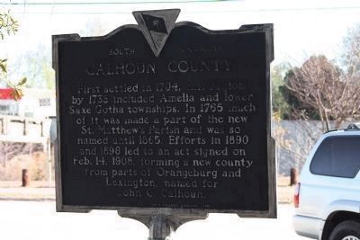
On South Railroad Avenue (State Highway 9-48) at Dantzier Street, on the right when traveling south on South Railroad Avenue.
First settled in 1704, this region by 1733 included Amelia and lower Saxe Gotha townships. In 1765 much of it was made part of the new St. Matthew's Parish and was so named until 1865. Efforts in 1890 and 1896 led to an act signed on Feb. 14, 1908 . . . — — Map (db m26057) HM
On Mt. Lebanon Road 0.5 miles west of Old State Road (U.S. 176), on the right when traveling west.
This is the original site of Mt. Lebanon Lutheran Church, organized January 13, 1844, as an extension of the St. Matthew's Church, Creston. Later, Mt. Lebanon Church moved to Cameron about 2 miles NW, dedicated its new building in 1917, and was . . . — — Map (db m27239) HM
On Fort Motte Road at Red Clay Road, on the right when traveling north on Fort Motte Road.
St. Matthew's Parish was established by the S.C. Colonial Assembly between 1765 and 1768. The first of four church buildings was erected in Amelia Township c. 1765. The parish church was incorporated by the S.C. General Assembly in 1788 as the . . . — — Map (db m237357) HM
On Old State Road (U.S. 176) at Old Swamp Road (State Highway 9-353), on the right when traveling west on Old State Road.
Sandy Run Church. This Lutheran church, one of the oldest in the state, is thought to have been organized ca.1765. By 1774, the Rev. Lewis Hochheimer was minister here. The church was incorporated in 1788 as "The German Lutheran Church of . . . — — Map (db m28827) HM
On F R Huff Drive (State Road 9-46) south of Mill Road, on the right when traveling south.
Bethel A.M.E. Church was established in 1865 and held its early services under a brush arbor. Bethel was the first A.M.E. Church in Lewisville (now St. Matthews). Trustees Robin Amaker, Jack Dantzler, and Frank Keitt purchased land from Jacob G. . . . — — Map (db m292419) HM
On Calhoun Road (State Road o-21) at Carr Street, on the right when traveling east on Calhoun Road.
In 1950, West End Calhoun County Library opened in a rented 4-room building off Calhoun Road to serve Black residents of Calhoun County. It was organized by local African Americans, who sought Calhoun County Co. Public Library (CCPL) support to . . . — — Map (db m292420) HM
On Old State Road (U.S. 176) north of Old Orangeburg Road, on the left when traveling north.
This African Methodist Episcopal (AME) congregation organized in 1880 when five trustees acquired one acre of land at this site. The first church was a simple wood frame building. It was replaced by a more substantial wood structure, which had a . . . — — Map (db m292417) HM
On Waterspring Road (State Highway 38-142) near Lime Kiln Road, on the left when traveling east.
This cemetery was the burial site of the Miller family from the early 1800s. The remaining stones erected in 1836, are to John Miller (1750-1854), soldier of the Revolution; his wife, Margaret Ott Miller; and their son, John Miller Jr. Their . . . — — Map (db m25184) HM
On East Main Street (Georgia Route 45) at South Bermuda Street (County Route 153), on the right when traveling west on East Main Street.
This county, created by Act of the Legislature Feb. 20, 1854, is named for John C. Calhoun, famed South Carolina Statesman, who resigned as Vice President of the United States in 1832 to return to the U.S. Senate and defend States Rights in debates . . . — — Map (db m27052) HM
This town, established in 1823, grew up around a store owned by Matthew Young (1803-1876), who was also postmaster 1831-43. It was first called Pressly's Station, for the post office opened in 1823 with David Pressly (1764-1834) as postmaster. The . . . — — Map (db m9397) HM
Gilmer CountyFormed, 1845, from Kanawha and Lewis. Named for Thomas Walker Gilmer, Secretary of the Navy in President Tyler's Cabinet, who was killed by the explosion of a gun on board the United States battleship, Princeton, February 28, 1844. . . . — — Map (db m73437) HM
On Big Otter Highway (West Virginia Route 16) 1 mile north of Nebo Walker Road (Local Route 16/1), on the right when traveling south.
Clay County. Formed in 1858 from Braxton and Nicholas. Named for the great Kentuckian, Henry Clay, who was so popular in western Virginia that in 1820 a monument was erected to him for his part in bringing the National Road to Wheeling.
. . . — — Map (db m137951) HM
Near John B Gordon Drive 0.1 miles east of Jefferson Davis Drive, on the right when traveling east.
Around 1850, Charles Milton Davis moved with his extended family from Aiken, South Carolina to create the new town of Dickey in the southwest part of Georgia near the present city of Albany.
Family lore states that the lavish manor home was . . . — — Map (db m208654) HM
On Old State Road (U.S. 176) north of Shrike Road, on the right when traveling north.
Burial place of Lt. Col. Olin M. Dantzler, C.S.A. Appointed Brigadier General 1 June 1864 Defender of Charleston, SC and Petersburg, VA His recorded notes to General P.G.T. Beauregard led to the location of the submarine H.L. Hunley in 1995 Killed . . . — — Map (db m134424) HM
On Old Number 6 Highway (State Highway 6) near Bluebird Trail, on the right when traveling south.
George Sterling was granted 570 acres of land here on March 14, 1704. During the lifetime of his daughter, Mary Sterling Heatly Russell, the plantation was a stopping place for Indians and travelers on the Cherokee Path. The Rev. John . . . — — Map (db m27218) HM
On Court Square (State Highway 28) south of Washington Street (State Highway 203), on the right when traveling north.
Abbeville's 6th courthouse - designed in beaux arts classical style by Edwards & Walter of Atlanta - dedicated in 1908 with City Hall/Opera House. (Two buildings indirectly financed by profits from Abbeville Dispensary, only one still operating . . . — — Map (db m14870) HM
Thin black lines indicate changes in relevance. Between each pair of lines entries are ordered geographically but all have the same relevance.
* Inflectional forms of words are their plurals, singulars, and possessives as well as gramatical tenses and similar variations.