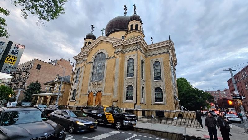
This church, designed by Louis Allmendiger and built between 1916 and 1921, adds unexpected color and drama to the neighborhood. The Greek cross plan and the copper-covered onion-shaped domes and octagonal belfries, all crowned by patriarchal . . . — — Map (db m299013) HM
Originally the center of a Dutch West India Company bowerie, or farm, the original portion of the Pieter Claesen Wyckoff House was built c. 1652 by Pieter and his wife Grietje Van Ness and is the oldest surviving structure in New York City. The . . . — — Map (db m30079) HM
Enslaved and free Africans performed much of the heavy labor to create New York's infrastructure, building roads, docks, and buildings of the early city. They assisted early craftsmen and manufacturers, and many became skilled artisans . . . — — Map (db m265011) HM
Built in 1800, the Hendrick I. Lott House incorporates the earlier 18th-century home of his grandfather Johannes E. Lott, a colonel in the American Army. The Lott House is a quiet reminder that during the Revolutionary War, Kings County consisted . . . — — Map (db m30086) HM
The landmarked Offerman Building at 503 Fulton St, designed by architect Peter J. Lauritzen, was originally built to house the S. Wechsler & Bros. department store. — — Map (db m253899) HM
Early in the morning of August 27, 1776, British troops came up the Narrows Road to attack American forces defending Brooklyn Heights. In and around this location, the highest natural point in Kings County, the outnumbered Americans put up a . . . — — Map (db m13250) HM
This impressive sculpture bust of Alexander Johnston Chalmers Skene, M.D. (1838-1900) honors a Brooklyn-based physician, medical researcher, college and hospital administrator whose lifetime of achievement had a broad impact on the medical . . . — — Map (db m108911) HM
On July 4, 1776, the Declaration of Independence proclaimed to the world that thirteen British colonies had joined together to create a new nation: the United States of America. Here in Brooklyn, only two months later, the survival of that new . . . — — Map (db m31009) HM
On July 4, 1776, the Declaration of Independence proclaimed to the world that thirteen British colonies had joined together to create a new nation: the United States of America. Here in Brooklyn, only two months later, the survival of that new . . . — — Map (db m30175) HM
In 1776, at the time of the Battle of Brooklyn in the Revolutionary War, the present Fulton Mall was known as the Road to Jamaica, a onetime Native American trail that had evolved into a major roadway connecting the farms of Kings . . . — — Map (db m305308) HM
On July 4, 1776, the Declaration of Independence proclaimed to the world that thirteen British colonies had joined together to create a new nation: the United States of America. Here in Brooklyn, only two months later, the survival of that new . . . — — Map (db m21613) HM
On July 4, 1776, the Declaration of Independence proclaimed to the world that thirteen British colonies had joined together to create a new nation: the United States of America. Here in Brooklyn, only two months later, the survival of that new . . . — — Map (db m30174) HM
On July 4, 1776, the Declaration of Independence proclaimed to the world that thirteen British colonies had joined together to create a new nation: the United States of America. Here in Brooklyn, only two months later, the survival of that new . . . — — Map (db m13255) HM
The Hendrick I. Lott House is one of fourteen remaining Dutch Colonial farmhouses in Kings County. It is listed on the National Register of Historic Places and is designated as a New York City Landmark. The house remains structurally sound and . . . — — Map (db m30200) HM
Squire Bozorth 1792-1853
Cowlitz County Kentucky Militia
•
George Bush 1789/90-1863
Thurston County Kentucky Militia
•
Asa Coombs 1796-1888
King County Tennessee Militia
•
Walter Crockett 1786-1869
Island County . . . — — Map (db m308907) WM
Until the late 19th century, the central business district of Brooklyn was found along the part of Fulton Street (today's Cadman Plaza West) on the other side of Borough Hall, leading to the Fulton Ferry pier. This "inland" part of Fulton Street . . . — — Map (db m253884) HM
In March 1776, American Revolutionary forces built Fort Stirling on this site to protect both civilian and military ships passing through the East River. Originally named "Fort Half-Moon" due to its crescent shape, control of the fort didn't stay . . . — — Map (db m309935) HM
This park is named for Hugh McLaughlin, Jr. (1823-1904), a local civic leader with tremendous influence in Brooklyn politics and in the religious life of his community. He was the youngest of ten children born to Irish immigrants who arrived in . . . — — Map (db m254182) HM
About the House
The Lott House was constructed in 1720 and by 1800, it was called "the finest country house in Kings County." A traditional Dutch-American farmhouse on the outside, its interior is much more grand. The Lott property . . . — — Map (db m265197) HM
About the House
The Lott House was constructed in 1720 and by 1800, it was called "the finest country house in Kings County." A traditional Dutch-American farmhouse on the outside, its interior is much more grand. The Lott property . . . — — Map (db m265203) HM
On July 4, 1776, the Declaration of Independence proclaimed to the world that thirteen British colonies had joined together to create a new nation: the United States of America. Here in Brooklyn, only two months later, the survival of that new . . . — — Map (db m30997) HM
What was here before?
Before it became a borough of the consolidated City of New York in 1898, Brooklyn was an independent municipality composed of numerous small towns and villages in Kings County. Williamsburgh was then a city in its own . . . — — Map (db m242894) HM
What was here before?
This site was once part of Tunis Johnson's (1838-1912) estate. He was one of the largest landowners in Kings County and the grandson of the third Mayor of Brooklyn, General Jeremiah Johnson (1766-1852).
How did this . . . — — Map (db m253916) HM
On July 4, 1776, the Declaration of Independence proclaimed to the world that thirteen British colonies had joined together to create a new nation: the United States of America. Here in Brooklyn, only two months later, the survival of that new . . . — — Map (db m309930) HM
As Union General Romeyn Ayres finished aligning his men, about 4:15 pm on April 1st, 1865, near the Gravelly Run Methodist Episcopal Church the order was given for the division to attack. Generals' Phillip Sheridan, Gouverneur Warren and Colonel . . . — — Map (db m245798) HM
John Brooks Henderson was born in Virginia and moved with his family to Lincoln County, Missouri when he was six years old. By age 10, he was an orphan.
Henderson overcame what could have been a life of obscurity to be a Pike County teacher, . . . — — Map (db m141281) HM
Thin black lines indicate changes in relevance. Between each pair of lines entries are ordered geographically but all have the same relevance.
* Inflectional forms of words are their plurals, singulars, and possessives as well as gramatical tenses and similar variations.