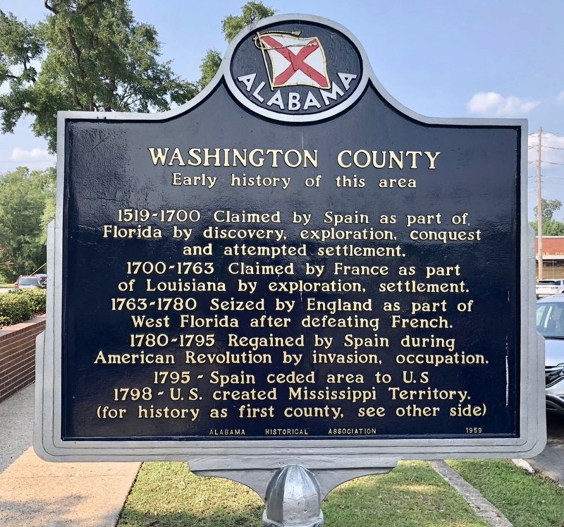
On Court Street north of Central Avenue (Alabama Route 56), on the left when traveling north.
Created in 1800 by proclamation of
governor of Mississippi Territory.
This was first U.S. civil government
in area that was to become Alabama.
Its original boundaries:
East to west: Chattahoochee to Pearl River;
South, 31° lat. . . . — — Map (db m122343) HM
On Saint Stephens Avenue at Howell Road, on the right when traveling north on Saint Stephens Avenue.
In 1848, Washington County designated the town of "new" St. Stephens
as the county seat of government. On November 23, 1853, the Alabama
Legislative Act 243 authorized the location and construction of the
courthouse at "Old Hazards Field," a . . . — — Map (db m305967) HM
On Old Saint Stephens Road at Jim Long Road when traveling east on Old Saint Stephens Road.
Spanish Fort 1789, Evacuated to the United
States, 1799; Designated Alabama Territorial
Capital, 1817.
Here was located U.S. Court and Land Offices,
and for some years the seat of justice
of Washington County,
September 28, 1922. — — Map (db m293764) HM
On Old Saint Stephens Road 1.2 miles east of Cement Plant Road, on the right when traveling west.
The St. Stephens Historical Commission was chartered by the State of Alabama in 1988: The board is charged with "acquiring, maintaining, protecting, promoting, and preserving" Alabama's first capital, St. Stephens.
Washington . . . — — Map (db m294044) HM
On East Washington Street, on the right when traveling east.
The oldest remaining colonial settlement in East Alabama from Florida to the Tennessee line and older than the county of Henry and the state of Alabama. An active trading post was located here in the Alabama Territory on “The Hill” early in 1819. . . . — — Map (db m83757) HM
On Holmes Valley Road 0.2 miles east of Reno Road, on the left when traveling east.
Washington County was a center for Native American activity for thousands of years and became the scene of military action during the Creek War of 1813-1814 & First Seminole War of 1817-1818. A Red Stick chief named Holms (Holmes) left Alabama . . . — — Map (db m148539) HM
On Red Fox Road 3.2 miles west of U.S. 43, on the right when traveling west.
Aiokpanchi, "Welcome,” to the Official Tribal Reservation
of the MOWA Band of Choctaw Indians. Chata hapia hoke!
"We are Choctaw.” We are glad you are able to visit us and
hope your visit to our Tribal Reservation is both rejuvenating
and . . . — — Map (db m149288) HM
On Roy's Store Road at Patton Road, on the left when traveling north on Roy's Store Road.
In 1916 the Washington County Board of Supervisors proposed the construction of 144.6 miles of paved roads throughout the county. In June 1916 voters approved a $950,000 bond, and in 1917 C.G. Kershaw of Birmingham, Alabama, was awarded the first . . . — — Map (db m154743) HM
On State Highway 36 south of Jungle Lane, on the right when traveling north.
A native of North Carolina, Robert Starke Armistead moved with his family to Alabama in 1818. He married Ann Sylvesta Carney in 1826 and they came to Texas in 1835. Armistead served in the Republic of Texas army in 1836 and with forces defending San . . . — — Map (db m125651) HM
On Cummings Street (Alternate U.S. 58) at Mont Calm Street, on the right when traveling west on Cummings Street.
John Campbell, the brother of Governor David Campbell, was born about 1788 in part of Washington County, that is present-day Smyth County. Campbell attended the College of New Jersey (later became Princeton) and Washington College. He was a member . . . — — Map (db m45255) HM
On U.S. 231 0.2 miles north of State Route 36, on the right when traveling north.
Abundant water and fertile land in this area south of the Tennessee River attracted pioneer settlement in the early 1800s. The community established here by three Virginia-born brothers, Hopkins, John, and Theophilus Lacy, took on their name and . . . — — Map (db m27611) HM
On U.S. 84 at River Street, on the right when traveling west on U.S. 84.
The Clarke-Washington Electric Membership Corporation was organized near this site on March 2, 1936, by some 83 members from Clarke and Washington Counties. This was the first rural electric cooperative organized in Alabama under an executive order . . . — — Map (db m80356) HM
On Farm to Market Road 531 0.2 miles south of Alternate U.S. 77, on the left when traveling north.
Stephen Bennett (1789-1874), a veteran of the War of 1812, and his wife Mary Ann "Polly" Breazeal Bennett (1798-1877), were born in South Carolina and lived many years in Alabama. They led a wagon train to Washington County in the Republic of . . . — — Map (db m291837) HM
On County Route 203 at Peaceful Valley Road, on the right when traveling west on County Route 203.
Alabama native Sampson Connell, Jr. (b. 1822) came to Texas with his family in 1834. Sampson, his father, and his brother participated at the Battle of San Jacinto in 1836. For his efforts, Sampson received a land grant in Washington County. He . . . — — Map (db m92902) HM
Near MP Daniel Esplanade at South 5th Street, on the right when traveling north.
World's largest Baptist University. Founded under charter issued by Congress of Republic of Texas on Feb. 1, 1845, and in continuous operation ever since.
Named for Judge R. E. B. Baylor (1791-1873), a native of Kentucky, an 1820s United . . . — — Map (db m180289) HM
On County Road 28 2.5 miles east of State Route 95, on the right when traveling east.
Side 1
Reuben Hicklin Hall Log Home
Reuben Hicklin Hall (1812-1890) and Mary Ann Strange (1814-1872) moved to Henry County by ox wagon from Washington County, Georgia, in 1845. They built a log home just south of here with slave . . . — — Map (db m71821) HM
On Omussee Creek Road 0.5 miles north of Picnic Road, on the right when traveling north.
The original builders of the Omussee Creek mound
had abandoned the site by around 1550, but the
area continued to be occupied by Native American
groups well into the early nineteenth century. As early as
the 1630s, Spanish missionaries from . . . — — Map (db m115037) HM
On Court Street at Central Avenue (Alabama Route 56), on the left when traveling north on Court Street.
Dedicated to the memory and
honor of all the men who served
in the Confederate States
Armies from Washington County
For these were men
Whom power could not corrupt
Whom death could not terrify
Whom defeat could not dishonor. . . . — — Map (db m122738) WM
Near West G Street (Tennessee Route 67) 0.1 miles west of Sabine Street, on the left when traveling west.
"Happy Valley" and Sabine Hill (1778-1853) In 1778, during the Revolutionary War, Andrew Taylor traveled from Virginia to what would later become eastern Tennessee. Taylor settled near this location on the Powder Branch of Buffalo . . . — — Map (db m174640) HM
On State Highway 7 at Ebenezer Church Road (County Highway 462), on the right when traveling east on State Highway 7.
Bardin King (1819-1891) and Elizabeth Susan Salter (1822-1879) married in Lowndes County, Alabama in 1842. The following year, they traveled west by wagon with their young son William and Susan’s parents and siblings, settling in Louisiana. Bardin . . . — — Map (db m156969) HM
On Farm to Market Road 1161 0.4 miles east of Farm to Market Road 102, on the right when traveling east.
William Jones Elliott Heard was born in Tennessee in 1801, the first of Stephen R. and Jemima M. Heard's nine children. Sometime in the 1820s Heard moved to Alabama where he married America Morton.
Heard received a land certificate from . . . — — Map (db m191904) HM
On County Road 430 0.6 miles south of County Road 248, on the left when traveling south.
Northern Boundary of:
British W. Florida 1764-83
Spanish W. Florida 1783-95
Mississippi Territory: 1798-1804
Washington County 1800-12
Clarke County 1812-15
Southern Boundary of:
British Illinois 1764-83
United States . . . — — Map (db m73532) HM
On 4th Avenue (U.S. 11) 0.6 miles north of Longshore Drive, on the right when traveling north.
Northern Boundary of:
British W. Florida 1764-83
Spanish W. Florida 1783-95
Mississippi Territory: 1798-1804
Washington County 1800-12
Clarke County 1812-15
Southern Boundary of:
British Illinois 1764-83
United States . . . — — Map (db m89725) HM
Early U.S. Military Presence
In 1825, President John Quincy Adams ordered the creation of a naval station at Pensacola, Florida
Territory. The Pensacola Navy Yard opened the following year.
The first U.S. Naval Hospital was built here . . . — — Map (db m160818) HM
The complexity of the company's history reflects the transformation of the electric power industry since the late nineteenth century as smaller utilities were consolidated into larger ones.
Created in 2000 by the merger of Northern States . . . — — Map (db m235069) HM
On New York State Route 32 at Herkimer Street, on the right when traveling south on New York State Route 32.
Victory
The Village of Victory sits perched on a bluff above the Hudson River, It owes its location to the highest waterfall on Fish Creek, the best waterpower site on the the creek's course from Saratoga Lake to the Hudson River. The . . . — — Map (db m129632) HM
On 6th Avenue North, on the left when traveling north.
Ridge and Valley
The Ridge and Valley physiographic province is an area between the Cumberland Plateau on the west and the Mountains on the east. This 9,000 square mile great valley extends diagonally across east Tennessee from Virginia to . . . — — Map (db m206495) HM
On Alabama Route 56 0.8 miles west of U.S. 43, on the right when traveling east.
The Sullivan Cabin was built on the east side of Bassett Creek, in
1874 by Gibeon Jefferson Sullivan, a Confederate soldier who served
in Co. A. 32nd Ala Infantry, an all-volunteer company made up of
men from Washington County. The cabin is a . . . — — Map (db m122341) HM
Thin black lines indicate changes in relevance. Between each pair of lines entries are ordered geographically but all have the same relevance.
* Inflectional forms of words are their plurals, singulars, and possessives as well as gramatical tenses and similar variations.