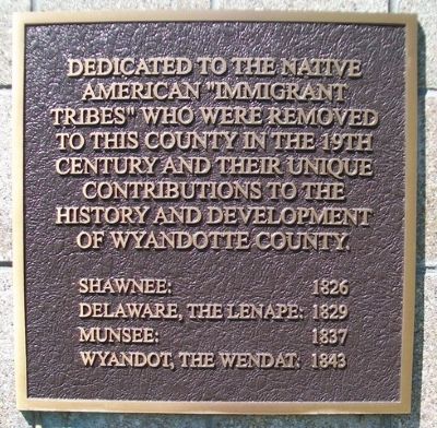
On College Parkway 0.4 miles south of Parallel Parkway, on the right when traveling south.
The Indian Removal Act of 1830 forced certain eastern tribes westward into Kansas. In recognition of past acts of friendship by the Wyandots, the Delaware agreed to sell them 36 sections of their holdings. The Delaware also graciously donated 3 . . . — — Map (db m69400) HM
In June, 1804, Lewis and Clark, exploring the Louisiana Purchase, camped where the Kansas river empties into the Missouri. Forty years later the Wyandot Indians were moved here from Ohio. Their tribal burial ground, Huron cemetery, may still be . . . — — Map (db m46303) HM
When the Pilgrims landed at Plymouth Rock, many different Indian nations occupied what is now the United States. European settlement gradually resulted in many of these native peoples being pushed to the west.
In 1825 the U.S. government . . . — — Map (db m46324) HM
In commemoration of the
ethnic communities present
in the new
Wyandotte County
created in 1859
Shawnee-Delaware • Wyandot • African • German
Irish • English • Scottish • Danish
1909
Within this 50 year span
the following . . . — — Map (db m46296) HM
On Central Avenue at 19th Street, on the right when traveling east on Central Avenue.
Eighteenth and Central Ave. was the "end of the line" for the Riverview Cable Car serving Riverview Blvd. (now Central Ave.) The promoter, Col. David W. Edgerton & Associates, made his first revenue trip with the cable line on May 22, 1888. . . . — — Map (db m69398) HM
On Kaw Drive (State Highway 32) near 78th Street, on the left when traveling east.
Just east of this marker, at a point where an old Indian trail led to the water's edge, Moses Grinter established the first ferry on the Kansas River. The year was 1831, and Grinter became the earliest permanent white settler in the area. His ferry . . . — — Map (db m46329) HM
The pioneer of the Wyandot Indians to the Kansas Valley in 1842. The leading man and constant friend of the Indian. A devout Christian and a good Mason. He leaves the craft on Earth and goes with joy to the great architect. — — Map (db m69393) HM
On Minnesota Avenue west of 4th Street, on the right when traveling west.
Where the Kaw river joins the mighty Missouri in its sweep eastward, has witnessed many events of historical significance to this area, among them:
1804. Lewis and Clark, on their epic exploring trip assaying the new Louisiana Purchase, . . . — — Map (db m69478) HM
Built by Moses R. Grinter in 1857 on the then Delaware Indian Reserve, this house was near the point where in 1831 he had begun operation of the first ferry on the Kansas River. For many years following its survey in 1837 the Fort Leavenworth - . . . — — Map (db m46338) HM
'In November, 1972, the citizens of Wyandotte County, Kansas, were good enough to elect me as the first black judge of the District Court in the history of the state, but today there are black judges of that rank and higher all over the nation, . . . — — Map (db m69396) HM
On North 4th Street at Ann Street, on the right when traveling south on North 4th Street.
On this site in the old town of Wyandotte, James A. Cruise (1839-1873) and his wife, Margaret Kerstetter Cruise (1843-1915), built a small home about 10 years after Kansas became a state, in 1861. Mr. Cruise became the first Register of Deeds of . . . — — Map (db m69464) HM
On Burlington Street (Missouri Route 9) at 10th Street, on the left when traveling south on Burlington Street.
…the high lands which is on the Northe Side [just above the Blue Water river] does not exceed 80 feet high, at this Place the river appears to be Confined in a very narrow channel, and the Current Still more So by Couenter [counter] . . . — — Map (db m67770) HM
On Madison Street north of West 8th Street, on the left when traveling south.
The Artist
Ed Hogan, creator of the Exodus Family, is a life-long resident of Kansas City, Kansas. Hogan was born in 1937 and graduated with a degree in Fine Arts from the Kansas City Art Institute. He went on to get a master of Arts . . . — — Map (db m199278) HM
Near Manchester Trafficway 0.5 miles north of East 63rd Street Trafficway when traveling north.
Clash at Byram's Ford
At 10:00 AM on October 22, 1864, six hundred feet in front of you, Lt. Col. George H. Hoyt of the 15th Kansas Cavalry formed a skirmish line to resist the advance of the Confederate army across the Blue River at Byram's . . . — — Map (db m226627) HM
On 7th Street Trafficway (U.S. 69) north of Ann Avenue, on the right when traveling north.
Tablet 1
The Origins of the Wyandots
The story of the Wyandot Nations is both heroic and bitter. Once among the greatest of Indian tribes in northeast America, a warrior race whose influence reached from Canada to Kentucky, the . . . — — Map (db m72957) HM
Thin black lines indicate changes in relevance. Between each pair of lines entries are ordered geographically but all have the same relevance.
* Inflectional forms of words are their plurals, singulars, and possessives as well as gramatical tenses and similar variations.