On South 6th Avenue, on the right when traveling north.
Which, under command of Col. Cooke, in the course of their 2,000 mile infantry march to the Pacific coast, arrived and raised the first American flag in Tucson.
December 16, 1846 — — Map (db m27281) HM
Near this site on December 16 – 17, 1846, the U.S. 101st Infantry ("Mormon") Battalion under the command of Colonel Philip St. George Cooke peacefully occupied the Presidio San Agustin del Tucson.
Organized in Council Bluffs, Iowa, to . . . — — Map (db m73983) HM
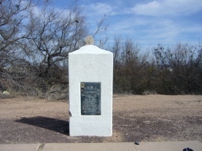
On North Pinal Avenue, on the right when traveling south.
Who camped here Dec 20, 1846
in rout to Cal. War with Mexico.
Erected By
Aaronic Priesthood Mesa 3rd Ward L.D.S.C.
Troop 57 Boy Scouts of America R.C.
Hugh Dana Sp.• Joseph Moody S.M. •
F.K. Pomeroy 1st Coun • T. Elmer Hastings Asst . . . — — Map (db m27207) HM
The Mormon Battalion of the U.S. Army camped here enroute to California December 17, 1846. During the war with Mexico, on the longest infantry march of record, they were first to unfurl the flag of the United States in Tucson.
This marker . . . — — Map (db m92383) HM
Near West 8th Street, 0.5 miles west of Somerton Avenue.
Mounted on back of monument
Mormon Battalion Crossing
This monument marks the approximate site of the crossing of the Colorado River by the Mormon Battalion on 10 and 11 January 1847.
The Mormon Battalion consisted of 500 . . . — — Map (db m62011) HM
Between 1846 and 1848, the United States and Mexico went to war. One of the major directives of the United States during this war was to secure its western border and to occupy California and the territory of New Mexico. The government asked for . . . — — Map (db m22686) HM
On Tragedy Springs Road near Carson Pass Scenic Byway (California Highway 88).
This campsite on the Kit Carson Emigrant Trail was a resting place for California settlers. It was named by members of the Mormon Battalion enroute to Salt Lake Valley. Three of their men, serving as advance trail scouts, were murdered here by . . . — — Map (db m21273) HM
Near State Highway 49. Reported permanently removed.
Members of the “Mormon Battalion,” returning from the war with Mexico, were enlisted by Sutter and Marshall to help construct Sutter’s Mill.
The Mormon members of the sawmill crew built a cabin near the mill during the winter of 1847. Earlier . . . — — Map (db m12158) HM
On North Hill Street, on the right when traveling north.
On this site stood Fort Moore built by the
Mormon Battalion during the War with Mexico.
This memorial honors the troops who helped to win the South West.
The Flag of the United States was raised here on July 4th 1847 by United States . . . — — Map (db m128896) HM
Dedicated to the valiant members of the historic Mormon Battalion who stopped here on March 20, 1847, as they marched from San Diego to Los Angeles. A division of the U.S. Army of the West, these brave soldiers, trusting in God, overcame incredible . . . — — Map (db m50351) HM
On California 79, 1.5 miles south of Sage Road, on the right when traveling south.
In January of 1847, some 350 soldiers of the
Mormon Battalion, including five officers
wives and a few children, passed through this
area of Temecula Valley. These soldiers, under
the leadership of Lt. Col. Philip St. George Cooke,
were on . . . — — Map (db m238755) HM
On Lytle Creek Road, on the right when traveling west.
Lytle Creek Canyon in the San Gabriel Mountains has a long and interesting history. It is named for Andrew Lytle, who served as a company commander in the famed Mormon Battalion during the Mexican War. Lytle was among the earliest settlers of the . . . — — Map (db m78514) HM
On Great Southern /Overland Stage Route of 1849 (County Route S2), on the right when traveling east.
The old way variously known as Sonora, Colorado River or Southern Emigrant Trail and later as Butterfield Overland Mail Route traversed Box Canyon just east of here. January 19, 1847, the Mormon Battalion, under command of Lt-Col. Philip St G Cooke, . . . — — Map (db m51580) HM
Here was a palm-studded desert resting place, 1826-1866, for Mexican pioneers, mountain men, the Army of the West, Mormon Battalion, Boundary Commission, Forty-Niners, Railway Survey, Butterfield Overland Mail stages, and California Legion. It was . . . — — Map (db m51578) HM
Near an un-named desert road, 0.5 miles east of Great Overland Stage Route (County Route S2).
This pass, Puerta, between the desert and the cooler valleys to the north, was used by the Mormon Battalion, Kearny's Army of the West, the Butterfield Overland Mail Stages, and emigrants who eventually settled the west. The eroded scar on the left . . . — — Map (db m145313) HM
No. 7
Dedicated
in commemoration
the heroic sacrifice and
history-making achievements
of the
Mormon Battalion
"whose march over 2000 miles
from Council Bluffs, Iowa to San Diego
help to win California for the Union
and open a . . . — — Map (db m51992) HM
The historic march of the Mormon Battalion -- -- More than 2000 miles through the wilderness -- -- was made in fulfillment of official U.S. orders. Brigham Young, Prophet – Leader of the Mormons, personally recruited these troops. The . . . — — Map (db m51990) HM
[Marker located on Front of Base:]
Mormon women were anxious to reach the glorious West and any means offered seemed an answer to prayer to help them on their way. When it was learned four laundresses would be allowed each of the five . . . — — Map (db m241388) HM
On San Felipe Road (County Highway 52) 0.7 miles east of Highway 79, on the left when traveling east.
In 1844, Gov. Manuel Micheltorena granted 44,322 acres to Juan Jose Warner who built this house. Gen. Kearny passed here in 1846; Mormon Battalion in 1847. First Butterfield Stage stopped at this ranch on Oct. 6, 1858 enroute from Tipton, Mo. to San . . . — — Map (db m51084) HM
On State Highway 49 at Rawhide Road (County Highway E5), on the right when traveling north on State Highway 49.
While they were crossing the plains with their families, five hundred Mormon men were inducted into the United States Army in July, 1846 to aid in the war against Mexico in California. The Mormon Battalion marched 2,000 miles from Council Bluffs, . . . — — Map (db m6842) HM
Near East Valley Hi Drive at South Parker Road (State Highway 83).
In 1846 the unsettled area that is now Parker, Colorado, consisted of wild open plains, inhabited only by local Indian tribes and passing trappers and traders. The Crosby-Brown Company, otherwise known as the Mississippi Saints, and detachments of . . . — — Map (db m97420) HM
On Stanton Avenue at Locust Street, on the right when traveling north on Stanton Avenue.
This memorial is the
Property of the State of Colorado
____
A detachment of United States Soldiers of
The Mormon Battalion
in the Mexican War spent the
winter of 1846-47 near this site. . . . — — Map (db m96068) HM
On State Highway 91, on the right when traveling north.
Charles Jefferson Hunt served in the Mormon Battalion as Captain of Company “A” and as assistant executive officer. In its historic march from Council Bluffs, Iowa to San Diego, California, 1846 - 47. His service won the commendation of . . . — — Map (db m48986) HM
Near U.S. Highway 275 (U.S. 275) 0.1 miles Iowa Highway 92 (State Highway 92).
One of the most remarkable infantry marches in American history began here in July 1846 with the mustering of the Mormon Battalion. Members of The Church of Jesus Christ of Latter-day Saints (Mormon) responded to the request from President James K. . . . — — Map (db m22662) HM
On Interstate 135, 4 miles south of Exit 72 (Interstate 135), on the left when traveling south.
On 3 September 1846, the Mormon Battalion camped near here on its way to fight in the war with Mexico. This small army of more than 500 men and officers had been recruited at Council Bluffs, Iowa, from among the Mormon pioneers (members of The . . . — — Map (db m80663) HM
The Mormon Battalion camped here for five days beginning 27 August 1846. The battalion's more than 500 volunteers and officers had been recruited from the Mormon pioneers (members of The Church of Jesus Christ of Latter-day Saints) at Council . . . — — Map (db m45056) HM WM
On State Highway 156, on the left when traveling west.
The Mormon Battalion camped here on 8 September 1846. The more than 500 volunteers in this little army were enlisted to fight in the war with Mexico. They had been recruited from among the Mormon pioneers (members of The Church of Jesus Christ of . . . — — Map (db m95885) HM
During the Mexican War, Mormon men served as a special battalion in the U.S. Army. They left lowa in July 1846 and marched through the Southwest to San Diego, building roads and American outposts along the way. They fought the Battle of San . . . — — Map (db m241721) HM
On Geronimo Trail, 1.5 miles east of Arizona / New Mexico State line, on the right when traveling west.
On November 28, 1846 the Mormon Battalion of the U. S. Army West crossed these mountains near this summit enroute to California during the Mexican War. Col. Cooke had dispatched scouts ahead to find the best route. An Indian guide, Charbonneau, . . . — — Map (db m91987) HM
In 1846, while leading the Mormon Battalion to California during the Mexican War, Lt. Col. Philip St. George Cooke blazed a wagon road from New Mexico to the West Coast. The potential use of the route for the railroad construction was one of the . . . — — Map (db m38236) HM
On U.S. 180 at milepost 145 at Butterfield Trail, on the right when traveling north on U.S. 180.
Here crossed the first road to Southern California opened for wagons by Capt. Cooke, who passed here in command of the Mormon Battalion, Nov. 1846 – later it became the California Emigrant Road – from 1858-1861, the route of the . . . — — Map (db m38302) HM
On West Frontage Road (U.S. 85), on the left when traveling north.
The Mormon Battalion
Council Bluffs, July 16, 1846
Fort Leavenworth, Aug. 2, 1846
Santa Fe, Oct. 9, 1846
San Diego, Jan 29, 1847
Erected June 16, 1940
[ Map of Mormon Battalion Route ]
The Mormon Battalion, composed . . . — — Map (db m150860) HM
On State Road 27 at milepost 8.1, on the right when traveling north.
"History may be searched in vain for an equal march of infantry"
Lt. Col. Cooke
The Mormon Battalion, of some 500 men marched through this area during November of 1846. The march covered over 2000 miles from Council Bluffs, Iowa to San . . . — — Map (db m38297) HM
On Main Street (State Highway 325) at Cimarron Avenue (U.S. 385), on the left when traveling west on Main Street.
From September 23 through 27, 1846, the Mormon Battalion crossed the northwestern portion of the Oklahoma panhandle. The little army's 500-plus volunteers, recruited for the Mexican War, were enlisted near Council Bluffs, Iowa, from among the first . . . — — Map (db m55260) HM
On Columbia Street at 300 North, on the right when traveling north on Columbia Street.
"I want to say to every man, the Constitution of the United States, as framed by our fathers, was dictated, was revealed, was put into their hearts by the Almighty who dwells in the heavens; and I tell you in the name of Jesus Christ it is as good . . . — — Map (db m132154) HM
On 300 North at East Capitol Blvd., on the right when traveling east on 300 North.
History
In May and June 1846, the services of the Mormon people--en route to the west--were officially tendered to the United States government, then at war with Mexico.
President James K. Polk authorized Colonel Stephen W. Kearney, . . . — — Map (db m35195) HM
Near East Capitol Boulevard north of East 300 North, on the left when traveling north.
[panel 1] Following the days of their severest persecutions in the winter of 1846-7, when the Mormon pioneers, driven from their beloved city of Nauvoo, Illinois, by mob violence, were scattered across the frozen plains of Iowa, there came . . . — — Map (db m167225) HM
Marker on Left:
Captain James Brown
Captain James Brown, Pioneer, Soldier and one of the founders of Ogden, enlisted in the Mormon Battalion of the U. S. Army in the Mexican War, July 16, 1846, at Council Bluffs, Iowa, and was made . . . — — Map (db m149971) HM