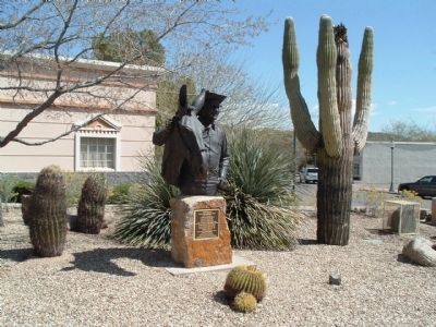
On North Tegner Street at East Apache Street, on the right when traveling north on North Tegner Street.
b. July 12, 1899 Hope, NM
d. October 25, 1971 Wickenburg, AZ
Known as the cowboy's cowboy
Admired and revered by townsfolk
Father and organizer of Turtle Association 1936 which became the Professional Rodeo Cowboy Association
1937 Owned . . . — — Map (db m29473) HM
Near Beachcomber Boulevard west of Kiva Drive, on the right when traveling west.
Site #6, now officially known as Lake Havasu Auxiliary Field #6, was acquired by the Army Air Force during World War II as an emergency landing field for the Kingman Army Air Field's Yucca Aerial Gunnery Range. The emergency field was established . . . — — Map (db m145825) HM
On North McCoulloch Boulevard east of Capri Boulevard, on the left when traveling north.
Dedicated to Captain James A. Wheeler, United States Air Force, Tucson, Arizona, and all members of the armed services who have given their lives in the maintenance of freedom. Captain Wheeler was killed in combat April 18, 1965, over South Viet . . . — — Map (db m31839) HM
On U.S. 93, 3 miles north of Willow Beach Road, on the right when traveling south. Reported damaged.
With its rugged mountains, deep canyons, stark deserts, and two large blue lakes, America's first national recreation area is a place of great contrasts. Lake Mead National Recreation Area (NRA) was established in 1964, well after the waters of the . . . — — Map (db m193366) HM
On East 2nd Street, 0.1 miles east of North Kinsley Ave.
US Route 66: The Mother Road
In 1926, the section of the transcontinental National Old Trails Highway that passed through downtown Winslow on Second Street became part of US Route 66, which ran from Chicago to Los Angeles. The highway was . . . — — Map (db m239369) HM
On Meteor Crater Road, on the right when traveling west.
NASA
On October 1, 1958, the National Aeronautics and Space Administration (NASA) was created to promote American civilian interests in space. Established at first to direct the nations efforts toward the scientific exploration of space, the . . . — — Map (db m71635) HM
This test capsule, named Boiler Plate 29A never flew into space. Instead, the capsule was built in 1965 to test the systems that helped Apollo space capsules float upright after splashdown at sea.
The test capsule represents an Apollo command . . . — — Map (db m161618) HM
On East 2nd Street, 0.1 miles east of North Kinsley Ave.
After World War II, Winslow's growth slowed as technology reduced the railroad industry's manpower requirements. In 1979, downtown businesses were devastated when the Interstate 40 bypass opened. Today, the economy is more diversified, and Winslow's . . . — — Map (db m239387) HM
Tucson Air Museum Foundation
of Pima County
Titan II Intercontinental Ballistic Missile Museum
Established May 8, 1986
571st SMS, 390th SMW
Davis-Monthan AFB
Strategic Alert July 1963 – November 1982
National . . . — — Map (db m26926) HM
On South 6th Avenue at West Oklahoma Street, on the right when traveling north on South 6th Avenue.
[Marker Front:]
This ground was the location
of the
First Municipal Airport
in the
United States
The Tucson City Council approved the
financing for the airport, July 21, 1919
and
the City of Tucson in cooperation . . . — — Map (db m8432) HM
Near Arizona Route 386, 12 miles south of W. Tucson-Ajo Hwy. (Route 86), on the left when traveling south.
Steward Observatory
90 inch Reflector
University of Arizona
Erected 1967
Board of Regents
Jack Williams Governor · George W. Chambers President · Elwood W. Bradford · Sarah Folsom · Wesley P. Gross · Leon Levy · Norma Barr Rockfellow · . . . — — Map (db m102921) HM
Near Arizona Route 386, 12 miles south of W. Tucson-Ajo Hwy. (Arizona Route 86), on the left when traveling south.
The accompanying picture shows a cross section of the solar vacuum telescope. This facility, built in 1973, is used to study the evolution of sunspots and other solar magnetic fields. It is operated daily by the National Solar Observatory (NSO) . . . — — Map (db m102918) HM
Near Arizona Route 386, 12 miles south of W. Tucson-Ajo Hwy. (Arizona Route 86), on the left when traveling south.
The octagon-shaped building that you see in the distance is the enclosure for the telescope of the WIYN Observatory. Completed in 1994, WIYN is owned and operated by the University of Wisconsin, Indiana University, Yale University, and the . . . — — Map (db m102920) HM
Near Sabino Canyon Road at North Kolb Road, on the right when traveling north.
On November 30, 1944, at 7:40 A.M. 18 airmen from Davis-Monthan Army Air Field died following a mid-air collision between two B-24 Liberator Bombers over the Pantano Wash. This bridge is dedicated to those brave men who lost their lives while on a . . . — — Map (db m100761) HM WM
Near East Valencia Road, 0.3 miles west of South Wilmot Road.
Douglas C-54D Skymaster Transport 1942-1975
On loan from the National Museum of the United States Air Force
2nd Plaque
Douglas C-54D
This aircraft served in the Berlin Airlift in 1949 and is painted as such (despite . . . — — Map (db m185679) HM
Near East Valencia Road, 0.3 miles west of South Wilmot Road.
Lockheed L-049
Constellation (Airliner) 1943-1948 *Star of Switerland *
On loan from
the U.S. Air Force Museum
Restored by Trans World Airlines — — Map (db m185677) HM
Near East Valencia Road, 0.3 miles west of South Wilmot Road.
Lockheed P-80B (F-80C) Shooting Star Fighter/ Fighter Bomber 1944-1958 On Loan From the National Museum of the United States Air Force — — Map (db m185882) HM
The SR-71 could cruise at speeds in excess of Mach 3, three times the speed of sound-at altitudes of 80,000 feet. On March 6, 1990 an SR-71 flew coast to coast in 68 minutes 17 seconds.
length-107 ft. 5 in.
wingspan--55 ft. 7 in.
two Pratt & . . . — — Map (db m92599) WM