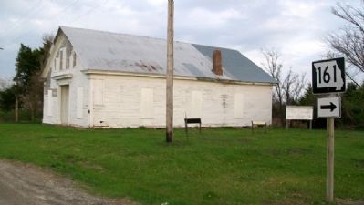
You are standing on the site of the Danville Female Academy, and at your front is the sole surviving building of the Academy, the chapel and dormitory.
The Female Academy was founded in 1853 by the Reverend James H. Robinson at a time when . . . — — Map (db m42744) HM
Williamsburg and its rural neighborhood, including the Loutre River valley to the east, were home to several famous, even notorious Southern guerrillas.
One such was Capt. Alvin Cobb of "Cobbstown," in western Montgomery County, Mo. A large, . . . — — Map (db m212623) HM
Cole County, Missouri
Established November 16, 1820
Dedicated in this bicentennial year to those who have given life to Cole County, from the generations of Ancient Ones before the settlers of European and African lineage who formed our . . . — — Map (db m169397) HM
The railroad was built in the early 1870's through Montgomery County. The first line crossed the county on a north/south route, it was the International & Great Northern (now Missouri Pacific). A short while later the Gulf Colorado RR took an east / . . . — — Map (db m180184) HM
Born in Virginia, Elijah Collard later settled on the frontier in Kentucky and in Missouri, where he fought in the War of 1812. Collard migrated to Texas in 1833. He was elected to the Consultation at San Felipe in 1835 and served on the General . . . — — Map (db m180242) HM
Old Auxvasse Presbyterian is one of the oldest congregations west of the Mississippi. But this hill on which the congregation first met in 1828 in a log church earlier hosted travelers along the Trial, some of whom likely were buried here before . . . — — Map (db m216974) HM
Kingdom City's name alludes to the Kingdom of Callaway. How Callaway County came to be called a kingdom is a story dating to the early months of the Civil War.
In Fall 1861, the Union controlled the St. Louis area but the rest of the state . . . — — Map (db m299140) HM
Beyond the Mississippi
The Boone's Lick Road was the first to bring settlers deep into the heart of the great Louisiana Purchase from early settlements west of the Mississippi River. It bore the nation's constant westward push, extending by . . . — — Map (db m247698) HM
1895
New Holstein
When a railroad passed through town, the community often adapted. Sometimes entire towns moved closer to the tracks or new towns grew around depots. At the railroad depot in the river bottoms south of Holstein, area . . . — — Map (db m169251) HM
The School Building Just Ahead of You Opened In 1912 as the Military Road School, the area's third public elementary for African Americans. For decades it was the only public school serving black children in Upper Northwest and nearby . . . — — Map (db m110235) HM
A native of Huntsville, Texas, Samuel R. Frost grew up in Navarro County and in 1863 enlisted in the Confederate Army. After the Civil War he studied law and was admitted to the bar in 1870. In the years that followed, Frost served as Navarro . . . — — Map (db m309070) HM
Nancy Navarro (born August 15, 1965) in Caracas, Venezuela. She graduated from the University of Missouri-Columbia with a Bachelor of Science in Psychology. She is the first Latina County council member in Montgomery County. She is the first . . . — — Map (db m205948) HM
Route 66, one of the original highways in the US Highway System, was established on November, 11, 1926. It became one of the most famous roads in the US, passing through Illinois, Missouri, Kansas, Oklahoma, Texas, New Mexico, Arizona and . . . — — Map (db m159643) HM
If you were a marching soldier, what would have been your impression of Montgomery County during the Civil War?
While the built environment may not have impressed travelers, the variety of natural resources in this area garnered admiration. . . . — — Map (db m74879) HM
• Caddo Indian burials were exposed accidentally during construction at this site in October, 1988. Subsequent archeological excavations by Ann Early identified 2 burials, a small cluster of residential features, and artifacts dating from the . . . — — Map (db m202077) HM
The Ingalls family arrived here in 1869, on the Osage Diminished Reserve, believing the land would soon be available for legal purchase. They had previously lived near present-day Rothville, in Yellow Creek Township, Chariton County Missouri, and . . . — — Map (db m268808) HM
The serenity of the Maryland countryside was
shattered on September 4-6, 1862, as 35,000 Confederate soldiers of the Army of Northern Virginia
waded across the Potomac River. Gen. Robert E. Lee, hoping to rally support in the divided
state, . . . — — Map (db m173131) HM
You Are At Overlook Entrance
Welcome To Huffman Metropark
Huffman MetroPark connects cyclists to the Miami Valley's paved trail network. Nature enthusiasts will discover year-round bird watching. Red-tailed hawks and great horned owls make . . . — — Map (db m285880) HM
(West face)
[Confederate States of America Emblem]
Dedicated to the glory and
honor of the Montgomery
County soldiers of the
Confederate States of America
for their unparalleled courage
and gallantry in defense of their
homeland and . . . — — Map (db m22220) WM
Thin black lines indicate changes in relevance. Between each pair of lines entries are ordered geographically but all have the same relevance.
* Inflectional forms of words are their plurals, singulars, and possessives as well as gramatical tenses and similar variations.