Patrick County, Virginia. Area 485 Square Miles. Formed in 1790 from Henry, and named for Patrick Henry, who thus had two counted named for him. General J.E.B. Stuart was born in this county.
North Carolina. North . . . — — Map (db m65786) HM
The Patrick County "Loveworks" sign, dedicated July 4, 2016, is the 51st LOVE sign in the State of Virginia. Measuring in at 9 feet in height and 6 feet in length, the Patrick County LOVE sign is one of the largest in the state. — — Map (db m304995) HM
Roanoke newspaper publisher Junius B. Fishburn donated the land to create Fairy Stone State Park. It is named for the cross-shaped crystals found in the region, which according to legend were formed from the tears of fairies. The National Park . . . — — Map (db m65852) HM
We are Virginia's Moonshine Heritage Trail
Our moonshine heritage has deep roots, tracing back to the region's early settlers who relied on the production of illicit distilled spirits as a means of survival and income. While its perception . . . — — Map (db m271604) HM
This was the westernmost point of the survey of the Virginia-North Carolina border run in 1728 by a joint commission from both colonies led by Col. William Byrd II of Westover. The exact end of the line was marked on October 26, 1728, by a blazed . . . — — Map (db m65542) HM
The site was about one-half mile north of the river. This was one of a chain of frontier forts ordered erected by the Virginia legislature early in 1756. The chain extended from Hampshire County (now West Virginia) to Patrick County on the North . . . — — Map (db m77510) HM
Henry County. Located in the foothills of southern Virginia, Henry County is named for Patrick Henry (1736-1799), Revolutionary leader and governor of the Commonwealth of Virginia. Henry lived in the county from 1779 to 1784. The General . . . — — Map (db m58373) HM
William Letcher, the maternal great-grandfather of James Ewell Brown Stuart, was born about 1750 near Petersburg, Virginia. He was the second son of Giles Letcher of Goochland County, who was born in Ireland, and his wife, Hannah Hughes, who was of . . . — — Map (db m162905) HM
Rock Spring Plantation, the home of Hardin and Nancy Cox Reynolds, is a State and National Historic Landmark. It is possible the house built by Hardin Reynolds is the first brick home constructed in Patrick County. Enslaved workers likely made . . . — — Map (db m304981) HM
The Reynolds Family Cemetery spans many generations - from the beginning of Rock Spring Plantation in the 1800s to the present. Abraham and Mary "Polly" Reynolds, who first settled in Patrick County, are buried here along with their son David, . . . — — Map (db m304987) HM
The Dan River flows over 200 miles from the Blue Ridge Mountains in Virginia to John H Kerr Reservoir. The river crosses the border of Virginia and North Carolina 8 times before joining the Roanoke River at Lake Kerr. It continues its journey . . . — — Map (db m264489) HM
"This son of Virginia"
Born on February 6, 1833, James Ewell Brown, "Jeb" Stuart was the eighth child of Archibald and Elizabeth Stuart. Stuart's birthplace, "Laurel Hil," was located on the fringe of the Blue Ridge Mountains, in Patrick . . . — — Map (db m295644) HM
Jack's Creek Covered Bridge
Designed by Walter Weaver of Woolwine and bulit by Charles Vaughn of Buffalo Ridge in 1914, the Jack's Creek Covered Bridge is the last remaining covered bridge in Patrick County. The bridge was placed on the . . . — — Map (db m305823) HM
After the murder of William Letcher in 1780, the history of the fifteen-hundred-acre farm that would become the birthplace and boyhood home of James Ewell Brown Stuart is complex, in some instances vague and uncertain. Shortly after her husband's . . . — — Map (db m267763) HM
Meadows of Dan. Patrick County is named for a fiddler, Patrick Henry, and is where the Piedmont Plateau meets the Blue Ridge Mountains. Settled in Revolutionary times, it has always been a musical place. Stuart, the county seat, is named for a . . . — — Map (db m104623) HM
Archibald M. Aiken Bridge
In honor of
Judge Archibald M. Aiken
Born: February 12, 1889
Judge: Corporation Court of Danville: 1950 to City Attorney: Danville, Virginia from 1919 - 1939 during which period he negotiated with . . . — — Map (db m262487) HM
The Historical Roadbed that you see before you dates from the earliest colonial times of what is now Patrick County. This road may have been in use as early as the 1750 period. Approximately one thousand feet of this historic road forms the eastern . . . — — Map (db m99841) HM
200 yards south is “Poplar Grove,” Penn’s old home and burial place. At age 21 he “won his spurs” leading a company under General Lewis at Point Pleasant. During 1780–81 he organized the first Revolutionary troops from Henry and adjoining counties, . . . — — Map (db m65815) HM
Dedicated to the memory of the crew of a B-24, based at Charleston S.C., that crashed on Bull Mtn., March 15, 1944, one-half mile south of the fire tower while on a training mission
Lt. Gilbert R. Felts - Pilot Elkin, N.C. •
Lt. John R. . . . — — Map (db m271743) HM WM
The L.H. Jones
Auditorium
Has been placed on the
National Register
of Historic Places
by the United States
Department of the Interior
Built in 1947-1948 largely by
students under the instruction of
trowel trades . . . — — Map (db m264081) HM
Henry County. Area 444 square miles. Formed in 1776 from Pittsylvania, Governor of Virginia. Henry lived in the county 1779-1784.
Patrick County. Area 485 square miles. Formed in 1790 from Henry, and . . . — — Map (db m290185) HM
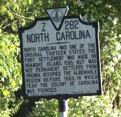
North Carolina. North Carolina was one of the original thirteen states. The first settlement was made on Roanoke Island, 1585, but was not permanent. Settlers from Virginia occupied the Albemarle region before 1663, in which year the colony . . . — — Map (db m54712) HM
Cooking in a plantation kitchen was daunting and required constant attention and care. The basic equipment needed for hearth cooking included a swinging crane, pot hangers such as S-hooks, trammels, or ratchets, a minimum of two Dutch ovens, . . . — — Map (db m304985) HM
Floyd County. Area 376 square miles. Formed in 1831 from Montgomery, and added to from Franklin. Named for John Floyd, governor of Virginia, 1830–1834. Buffalo Knob is in this county.
Patrick County. Area 485 square . . . — — Map (db m104615) HM
Just south of here is the site of Poplar Grove, home and burial place of Abram Penn, Revolutionary-era leader. Penn commanded a company during Dunmore's War against the Shawnee in 1774. The next year he was elected to the Pittsylvania County . . . — — Map (db m304868) HM
In 1728, Col. William Byrd II, founder of Richmond and builder of Westover on the James, led a party of surveyors from Norfolk westward into the frontier to determine the dividing line between the colonies of Virginia and North Carolina. In . . . — — Map (db m298679) HM
The Grave of William Letcher is the oldest in Patrick County with an inscription that reads:
"In memory of William Letcher, who was assassinated in his own house in the bosom of his family by a Tory of the Revolution, on the 2nd day of August, . . . — — Map (db m162901) HM
On this site, stood the outbuilding that served as the kitchen for the Stuart family. As was the custom in those days kitchens were housed in buildings separate from the main dwelling for protection against a fire that might erupt as a result of . . . — — Map (db m99842) HM
In 1843, brick-making and construction of the stately home of Hardin and Nancy Jane Reynolds began and continued into the next decade. The bricks were likely made on the property by skilled enslaved workers. The house was built in two sections, . . . — — Map (db m304986) HM
(East side)
In memory of Maj. Gen. J. E. B. Stuart C.S.A.
Born near Stuart, Patrick County, Virginia on February 6, 1833
Mortally wounded in Battle of Yellow Tavern
Died May 12, 1864
(West side)
Erected to the memory . . . — — Map (db m271625) WM
(Left Side)
From the Blue Ridge Mountains to the Coalfields region, southwest Virginia is blessed with historic and contemporary music venues, musicians, and fretted instrument makers. Historically isolated, the region retained its . . . — — Map (db m271623) HM
[Monument's east side]:
Commanding Cavalry Corps
Army Northern Virginia
Confederate States of America
***
This statue erected by his comrades
and the City of Richmond
A.D. 1906
[Monument's south side]:
“Tell . . . — — Map (db m9150) HM
Thin black lines indicate changes in relevance. Between each pair of lines entries are ordered geographically but all have the same relevance.
* Inflectional forms of words are their plurals, singulars, and possessives as well as gramatical tenses and similar variations.