17 entries match your criteria.
South Carolina, Beaufort County Historical Society Historical Markers
By Mike Stroud, January 2011
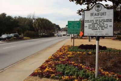
Beaufort Marker, moved to a new location in 2010, looking west along Boundry Street (US 21)
| On Boundary Street (U.S. 21) near Ribaut Road, on the right when traveling west. |
| On Craven Street, on the right when traveling east. |
| On Carteret Street (U.S. 21), on the right when traveling west. |
| On Scott Street, on the left when traveling north. |
| On Bay Street near Scott Street, on the right when traveling east. Reported missing. |
| On Church Street south of King Street when traveling south. |
| On Bay Street, on the right when traveling west. |
| On Craven Street at Carteret Street (Business U.S. 21), on the left when traveling east on Craven Street. |
| On May River Road (State Highway 46) at Verdier Cove Road, on the right when traveling east on May River Road. Reported missing. |
| On Dr. Martin Luther King Drive (State Highway S-7-45), on the right when traveling south. |
| On Trask Parkway (U.S. 21) near Parker Drive, on the right when traveling south. |
| On Pinckney Wildlife Refuge near William Wilton Parkway (U.S. 278), on the right. |
| On Pinckney Wildlife Refuge north of William Wilton Parkway (Route 352), on the right when traveling north. |
| On Lands End Road (State Highway 45), on the left when traveling south. |
| On Old Sheldon Church Road north of Bailey Road, on the right when traveling north. Reported permanently removed. |
| On State Highway 462, 0.1 miles south of State Highway 27-336, on the left when traveling south. |
Jun. 15, 2024