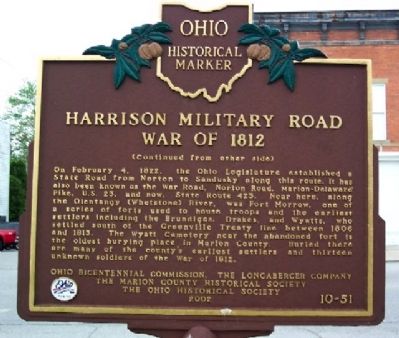
Side A: The first road through Marion County followed the Scioto Trail of the Native Americans. This 120-foot wide strip through Wyandot territory led from Lower Sandusky (Fremont) to the Greenville Treaty Line. A confederation of Ohio tribes . . . — — Map (db m22923) HM
Doctors Charles Elmer Sawyer and his son, Carl Walker Sawyer, opened Sawyer Sanatorium on White Oaks Farm in 1911, Built to provide physical and emotional healing in a unique environment, the complex incorporated six patient bungalows, houses for . . . — — Map (db m285816) HM
This grass land, extending one mile east between the road and the railway, is one of the few surviving remnants of the once extensive prairies that were part of pioneer Marion County. This strip, preserved by chance when the railway and road were . . . — — Map (db m29127) HM
The Oorang Indian football team was founded by LaRue native Walter Lingo (1890-1966), owner of the Oorang Airedale Dog Kennels. The team, comprised of Native American Indians, played in the National Football League (NFL) in 1922-23.
The star . . . — — Map (db m27018) HM
Thomas Stinson Cummin, owner of a successful dry
goods store, built his home in the early 1870s on
the outskirts of the growing village of Marion. The
home was purchased in 1889 by Henry M. Barnhart,
an inventor, and co-founder of the Marion . . . — — Map (db m221680) HM
Jacob Foos, while surveying the Military Road north from Fort Morrow to Fremont during the War of 1812, dug a well at this site. General William H. Harrison and his troops, on their way to Lake Erie, camped here and drank from the well. This area . . . — — Map (db m29048) HM
This is Marion County's fourth courthouse and the second at this site. The cornerstone was laid on July 4, 1884. Costing $115,000, it was completed in 1885 by contractors Leffler and Bland. In 1973 the courthouse was placed on the National Register . . . — — Map (db m29095) HM
The Marion Mausoleum represents a time in early 20th-century
America in which burial practices changed because of advances in
engineering and construction materials, concerns about hygiene, and
a new rise in wealth among the middle class. . . . — — Map (db m117821) HM
Marion civic leaders Shauck Elah Barlow and Ida Harsh Barlow built “Waldhelm,” their Colonial Revival residence, between 1903- 1905. Ida Barlow, then president of the Marion Women’s Club, hosted a December 1905 meeting in her new home. Members . . . — — Map (db m224218) HM
Was born on this site Nov. 20, 1884. He graduated from Marion High School in 1901, Princeton University in 1905, and from Union Theological Seminary. Thomas, a clergyman, and the son of Marion's Presbyterian minister, was a tireless worker for . . . — — Map (db m27030) HM
Marion founder Eber Baker donated this two-acre plot for use as a
cemetery shortly after platting the village in 1822. The oldest
legible headstone bears an 1812 burial date, indicating that it may
have been moved to the site after the opening . . . — — Map (db m94914) HM
Side A On March 2, 1942, four months after the U.S. entered WWII, farmers living between Marion-Williamsport and Marseilles-Galion Roads and between State Route 98 and the Norfolk & Western Railroad were notified to vacate their farms by . . . — — Map (db m94705) HM
Side A:
Early in 1942, during World War II, the U. S. Army Corps of Engineers acquired 640 acres along two miles of U. S. Route 30 South (now State Route 309) from ten landowners. By June 11 of that year, the farm families were removed and . . . — — Map (db m29126) HM
The U.S. Army built a two-story blockhouse on a nearby
hill during the War of 1812. The blockhouse was one of a
series of such structures erected along the Greenville
Treaty line to guard against Native Americans who
supported the British during . . . — — Map (db m94537) HM
This site was once a twenty-four acre camp for Prisoners of War established on the grounds of the Marion Engineer Depot. The Depot was a major supply and logistics site of the U.S. Army Engineers during World War II. The first contingent of POWs . . . — — Map (db m29115) HM
(Front):4th Ohio Infantry. 1st Brigade, 3rd Division, 2nd Corps. Carroll's Brigade. Ohio's Tribute. (Left):On the evening of July 2, 1863. Carroll's Brigade was sent from its position with the 2nd Corps to re-enforce this position of . . . — — Map (db m16945) HM
The single-span Parker Through Truss Bridge that previously carried State Route 47 over the Scioto River at this location was constructed by the Standard Engineering Company of Toledo shortly after the Flood of 1913 destroyed the wrought iron . . . — — Map (db m26984) HM
At the point where U.S. Highway 51 and the Jefferson-Marion County road meet, the Third Principal Meridian intersects its east-west base line. This cardinal point was established by a Federal surveyor on February 1, 1815. At least 60 percent of the . . . — — Map (db m167467) HM
The Underground Railroad
The Underground Railroad was neither underground nor a railroad, but a system of loosely connected safe havens where those escaping the brutal conditions of slavery were sheltered, fed, clothed, nursed, concealed, . . . — — Map (db m94909) HM
On December 31, 1821, a 78-mile state road was authorized from the Ohio border to Indianapolis through Brookville, to be built with required citizen labor. Commissioners filed a survey report June 24, 1822 for the Brookville State Road. On January . . . — — Map (db m44713) HM
Marion County was named for the Revolutionary War general, Francis Marion of South Carolina, the legendary “Swamp Fox.” It was formed in 1842 from Harrison and Monongalia Counties. The first courthouse, a two-story red brick structure, was completed . . . — — Map (db m174871) HM
Side A National Road in Marion County
Workers built the National Road through this area in the 1830s, nearly four decades before Irvington’s founding.
A constant stream of travelers on the road drew business to the area. The first commercial . . . — — Map (db m174717) HM
Born in Alabama. Joined W. P. Lane Rangers, C.S.A., 1861; was discharged 1865, rank of farrier.
Served as sheriff-tax collector for Marion County, 1874-1876.
In April, 1877, sent as agent of the state of Texas to bring Abe Rothschild back . . . — — Map (db m95672) HM
On April 20, 1863, Confederate Gens. William E. “Grumble” Jones and John D. Imboden began a raid from Virginia through present-day West Virginia against the Baltimore and Ohio Railroad. Taking separate routes, they later reported . . . — — Map (db m21232) HM
Tiny Prince Charming
Foaled: April 13, 2006
Tiny Prince Charming, a Percheron horse, is an icon to Ocala/Marion County during the holidays.
Raised by the Amish in Ohio, Tiny Prince Charming started his life plowing fields and . . . — — Map (db m310847) HM
The Underground Railroad
The Underground Railroad was neither underground nor a
railroad, but a system of loosely connected safe havens
where those escaping the brutal conditions of slavery
were sheltered, fed, clothed, nursed, concealed, . . . — — Map (db m92076) HM
In the spring of 1847 four sailing vessels carrying 800 freedom-seeking Hollanders landed at Baltimore. They were met by Dominie Henry Peter Scholte, their faithful leader, who led them across the Alleghenies to Pittsburgh and down the Ohio and . . . — — Map (db m235885) HM
Christmas Raid
December 31, 1862
Robert Colvin's Warehouse
Postmaster Robert Colvin owned the tobacco warehouse, which also housed the post office, that once stood here. During the Civil War, the U.S. Government leased the . . . — — Map (db m99293) HM
Long ago, when the Great Spirit created Valley Falls, he made a masterpiece, which no writer's pen nor artist's brush has been able to do justice. Here was the ideal site for the ancient campfire of the children of nature to supply their needs, . . . — — Map (db m206430) HM
Thin black lines indicate changes in relevance. Between each pair of lines entries are ordered geographically but all have the same relevance.
* Inflectional forms of words are their plurals, singulars, and possessives as well as gramatical tenses and similar variations.