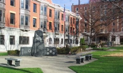
On Broad Street at Main Street, on the right when traveling south on Broad Street.
United States of America Congressional Medal of Honor Recipients State of Ohio, Fairfield County Civil War
Davidson, Andrew - Asst. Surgeon - Mississippi 1863
Dorsey, Daniel Allen - 1st Lt. - Georgia 1862
Gregg, Joseph Olds - Captain - . . . — — Map (db m12157) HM
On County Route 5, on the left when traveling north on County Route 5. Reported permanently removed.
John Crawfis, Fairfield County, Ohio native, and wife Sarah (Moorehead) bequeathed two grants of $25,000 and five acres for schools in Fairfield and Putnam counties in Ohio in 1880.
Constructed in 1889, Crawfis College, Putnam County, a . . . — — Map (db m283552) HM
Near North High Street (Ohio Route 37) at East Fair Avenue.
Fairfield County quickly mobilized after the attack on Ft. Sumter, South Carolina on April 12, 1861 and the beginning of the Civil War. Parts of the county fairgrounds became Camp Anderson, in honor of Major Robert Anderson who commanded Fort . . . — — Map (db m119493) HM
On Fair Avenue near Broad Street, on the left when traveling east.
This museum is the product of the public spirited cooperation of the citizens of Fairfield County
——————
The log house was dismantled and erected by the Fairfield County Commissioners
——————
The site was provided by the Fairfield County . . . — — Map (db m61842) HM
On Center Street at Market Street, on the right when traveling east on Center Street.
This area was set aside in 1829 by
Carroll's founder, William Tong,
for a market house, a place where
goods were bought, sold, and traded.
Neighboring Market Street got its
name from the planned structure.
However, Tong died in . . . — — Map (db m137620) HM
On Main Street (U.S. 22) at Pearl Avenue, on the right when traveling west on Main Street. Reported missing.
The purpose of the Ohio Military Hall of Fame is to recognize those Ohio individuals who served in the United State Military and distinguished themselves by displaying extraordinary heroism in action against an enemy of the United States while . . . — — Map (db m35426) HM
On Ohio Route 309 east of Jacob Parrot Rd. ( Route 171), on the right when traveling west.
Buried here. Born July 17, 1843 in Fairfield County, Ohio. Died December 22, 1908. At 18 he enlisted in Company K, 33rd Ohio Volunteer Infantry Regiment and was the youngest member of the famous Andrews Raid. The raiders seized “The General” . . . — — Map (db m277237) HM
This building, the original Liberty Twp. No. 6 School, was presented to the Fairfield County Agriculture Society by the Arthur Weakley Family of Baltimore, Ohio, August, 1976. The original school house bell was presented by Douglas A. Weakley of . . . — — Map (db m61844) HM
Jacob Parrott, a cabinet maker from Fairfield County, Ohio was a Union soldier with 33rd Ohio Infantry.
The April 1862 mission, led by civilian spy James Andrews, was designed to cut off Confederate supply lines by destroying rail tracks . . . — — Map (db m232590) HM WM
On North Main Street at West Water Street, on the right when traveling south on North Main Street.
On this spot in 1848, Jacob Bope constructed one of the largest warehouses on the Ohio and Erie Canal. Bope, a Virginia native who came to Ohio as a child, was a well-noted carpenter and craftsman in the Fairfield County area. He was known . . . — — Map (db m298026) HM
On Crockett Drive at Memorial Park Drive, on the right when traveling north on Crockett Drive.
MG Fred L. Walker (revered commanding General of the Fighting 36th Infantry Division) was born on June 11, 1887, in Fairfield County, Ohio and graduated from Ohio State University in 1911. He entered the regular army on February 11, 1911. He . . . — — Map (db m254270) HM WM
On Center Street just north of Canal Street, on the left when traveling east.
Canals were an important means of transportation when Carroll was founded in 1829 by William Tong and his brother Oliver, who chose this site because it was where the proposed intersection of the Lancaster Lateral Canal and Ohio-Erie Canal would be . . . — — Map (db m80624) HM
On Market Street (Ohio Route 664) just south of Main Street, on the right when traveling north.
The Underground Railroad in Rushville. Rushville was known as an important stop on the Underground Railroad in Ohio. Many fugitive slaves fled North to Canada while relying on a network of secret safe houses along the way. Several of these . . . — — Map (db m291933) HM
On Canal Road (County Route 100), on the right when traveling north.
How Does The Canal System Work?
The Ohio-Erie Canal was constructed with two summit levels: one near Akron in Summit County and the other, the Licking Summit, in Licking and Fairfield Counties. Reservoirs of water were created on both summit . . . — — Map (db m250206) HM
Near Granville Pike (Ohio Route 37) at College Avenue, on the right when traveling north.
Built in 1881, John Bright #2 covered bridge
originally spanned Poplar Creek on Bish Road near
Baltimore, Ohio. It is named after pioneer settler
John Bright, whose family farm was located near
the original site. August Borneman of . . . — — Map (db m224964) HM
On Covered Bridge Road (County Route 1518) 1 mile west of Bannock-Uniontown Road (County Route 331), on the right when traveling east.
Built 1891
Relocated 1975
This covered bridge was donated to Belmont County by Fairfield County, Ohio. Belmont County's last covered bridge located on Captina Creek, was destroyed in 1953.
County Commissioners
Aj Sargus • J. F. Giffen • C. . . . — — Map (db m271648) HM
This building, the original C & O Depot at Carroll, Ohio, was presented to the Fairfield County Agricultural Society by Mr. & Mrs. James D. McGill August 1966. It will be preserved for Historical purposes. — — Map (db m61848) HM
On Johnstown Road/Main Street (U.S. 62) 0 miles east of Route 605, on the right when traveling east.
Side A:
A tavern and inn, for which Noble Landon (1783-1866) obtained a liquor license in 1835, formerly occupied the southeast corner of High and Main streets. In 1837 Landon and William Yantis laid out the town of New Albany in 50-by-100-foot . . . — — Map (db m14452) HM
On Baltimore-Somerset Road (Ohio Route 256) 0.1 miles west of the railroad tracks, on the left when traveling west.
Back in the late 1800's and early 1900's, Thurston was the railroad town which everybody knew. The town was the only place in southeast Ohio which a train could turn around 360 degrees and choose which track it would want to go on. Thurston had a . . . — — Map (db m24813) HM
On Main Street (U.S. 22) west of High Street, on the left when traveling east.
The Reese-Peters House, home of the Decorative Arts Center of Ohio, is an exceptional example of transitional Greek Revival architecture demonstrating characteristics of both Federal and Greek Revival styles. The house was built in 1835 . . . — — Map (db m137813) HM
On Diamond Street at Park Street South, on the left when traveling south on Diamond Street.
John Sherman 1923-1900
Born in Lancaster, Fairfield County, John Sherman moved to Mansfield to practice law and was elected to Congress in 1854 as one of the first Republicans. In 1861, Sherman was elected to the U.S. Senate. An authority on . . . — — Map (db m20684) HM
On Main Street (U.S. 22) east of Graceland Drive, on the left when traveling east.
The Former Site of
The Fairfield County
Children's Home
1743 East Main Street
Lancaster, Ohio
has been placed on the
National Register
of Historic Places
by the United States
Department of the Interior
[Placed] December . . . — — Map (db m79991) HM
On North Broad Street at East Wheeling Street, on the right when traveling north on North Broad Street.
A Home for Sarah Maccracken.
The first owners of the home were
Samuel & Sarah Maccracken. Samuel
was a businessman, real estate investor,
an influential board member of
several state institutions, and, at one
time, was considered the . . . — — Map (db m241207) HM
On Neil Avenue at West 12th Avenue, on the right when traveling north on Neil Avenue.
"My memories of Mirror Lake include a calm place to study and people watch. While seeing these students, I imagined the great things these Buckeyes walking around me could accomplish.
When my mother was at The James in 2011 . . . — — Map (db m298605) HM
Thin black lines indicate changes in relevance. Between each pair of lines entries are ordered geographically but all have the same relevance.
* Inflectional forms of words are their plurals, singulars, and possessives as well as gramatical tenses and similar variations.