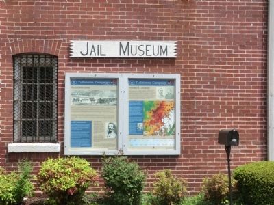
On Bluff Street at Dinah Shore Boulevard (Tennessee Route 50), on the right when traveling north on Bluff Street. Reported permanently removed.
From June 24th to June 27th, the Union Army of the Cumberland had moved flawlessly to maneuver the Confederate Army of Tennessee out of its position south of the Highland Rim. As Rosecrans would later say, only heavy rains had prevented a complete . . . — — Map (db m207282) HM
On South Jefferson Street near Dinah Shore Boulevard (Tennessee Highway 16), on the left when traveling south.
Soldier of the American Revolution Speaker of the First Tennessee Legislature Brigadier General, War of 1812The town of Winchester was created as the seat of justice for Franklin County, November 22, 1809, by Act of the Tennessee Legislature Marker . . . — — Map (db m31650) HM
On Tennessee Street (Tennessee Route 16), on the left when traveling west.
In this locality, on Feb. 24, 1861, occurred the mass meeting as result of which Franklin County seceded from the State of Tennessee, at the same time petitioning the then Confederate State of Alabama to annex it. The secession of Tennessee June 24, . . . — — Map (db m24666) HM
On 1st Avenue NW at South High Street, on the left when traveling west on 1st Avenue NW.
When Tennessee failed to secede from the Union on February 9, 1861, Franklin County residents met here at the courthouse. They listened to attorney Peter Turney’s forceful speech offering resolutions in favor of secession and reportedly adopted them . . . — — Map (db m75226) HM
On Green Hill Cemetery Road 0.1 miles east of Atwood Avenue, on the right when traveling north.
Officially, 23,703 African Americans in Kentucky responded to the call to arms by President Lincoln and Frederick Douglass to join the ranks of the newly organized United States Colored Troops. Units were organized with men from across the . . . — — Map (db m84675) HM
On S. Water Street, on the left when traveling south.
Side 1
Oka Kapassa (Ococoposa), meaning "Cold Water", was the Chickasaw name given to Spring Creek and to a trading post established near the Tennessee River about 1780. About 1817, Michael Dickerson and others were greeted at what by . . . — — Map (db m83393) HM
On Short Street west of Mechanic Street South, on the left when traveling west.
Lynchburg was a mere crossroads village in 1861, but the war and the years that followed it transformed this place. By the end of April 1861—six weeks before Tennesseans formally voted to secede—local men had formed Co. E (Lynchburg Rangers), 1st . . . — — Map (db m152104) HM
On North Grove Street (Farm to Market Road 1997) at Rainey Street, on the left when traveling north on North Grove Street.
Homesite of Isaac Van Zandt (1813-1847), one of founders of Marshall, a noted frontiersman, debater, lawyer, statesman; served in 5th and 6th congresses of Republic of Texas; was Charge d'Affaires to United States, 1842-1844, in governor's race when . . . — — Map (db m191312) HM
Tennessee native Khleber Miller Van Zandt moved to east Texas as a child. After serving as a major in the 7th Texas Infantry Regiment, C.S.A., he came to Fort Worth in 1865. A merchant, banker, and rancher, he was instrumental in making the city a . . . — — Map (db m264157) HM
Near Railroad Avenue west of Depot St, on the left when traveling east.
Arthur St. Clair Colyar played a major role in the raising of Tracy City like a phoenix from the ashes of the Civil War to an industrial giant of the late 19th century. Born In Washington County near Jonesboro, he migrated at age of nine with his . . . — — Map (db m277155) HM
Near Kasserman Switch Lane at U.S. 64, on the right when traveling west.
Revolutionary Soldier at Kings Mountain. Intrepid Indian fighter in some twenty battles. Member of First Constitutional Convention of Tennessee (1796) from Washington County. Member of Legislature from Franklin County. — — Map (db m315712) HM
On Highway 156 at Pinetree Rd. (County Highway 156), on the right when traveling north on Highway 156.
Allan Gipson, a pioneer settler of Franklin County (1814), was a merchant, planter, and original benefactor to the University of the South. He dedicated a large tract to the Sewanee Domain. Gipson served as a private in the Tennessee Mounted . . . — — Map (db m116015) HM
On 1st Avenue SE (Business U.S. 64) at South Jefferson Street, on the left when traveling east on 1st Avenue SE.
In memory of COLONEL JAMES LEWIS Born April 6, 1756 Albemarle County Virginia Died February 21, 1849 Franklin County Tennessee Served with distinction in the Revolutionary War. Participated in the Battles of White Plains, Trenton, . . . — — Map (db m31647) HM
On Cowan Hwy (U.S. 64), on the right when traveling east.
1 ½ mi. S.E. on the Boiling Fork of Elk. Oldest church in Franklin County. Founded 1808 by the Alexander, Cowan, Keith, McCord, Weir, and other pioneer Scots-Irish Presbyterian families. First Presbyterian congregation in Tennessee to transfer . . . — — Map (db m25641) HM
On Polly Crockett Lane west of Buncombe Rd, on the right when traveling north.
David Crockett's Birth and Childhood
David was born in eastern TN on August 17, 1786. His parents
were John and Rebecca Crockett. David was 8
years old when he moved to Cove Creek,
Tennessee with his family. His family bought land
next . . . — — Map (db m284412) HM
Native Tennessean
David Crockett was born in 1786 in Greene County,
Tennessee. In 1811, he moved his wife, Polly, and two sons
to Lincoln County, and in 1813 to Franklin County. When
the Creek War started Crockett mustered into the . . . — — Map (db m207976) HM
Lulu Colyar Reese was a socially prominent clubwoman who became active in Memphis education and politics as an advocate for free textbooks and child labor laws. In 1916, she was one of the first two women elected to the Memphis City Board of . . . — — Map (db m204266) HM
On County Road 3070 0.1 miles west of County Road 115, on the right when traveling west.
Primitive Baptist Church charted 1842.
Oldest marked grave 1870.
Land donors to expand are listed on the historical plaque
located in the center of cemetery grounds.
Perpetual care established in May 1968.
Gate erected in 1980.
Arch . . . — — Map (db m234989) HM
On County Road 3070 0.1 miles west of County Road 115, on the right when traveling west.
Established in 1845, Providence Cemetery served as a burial ground for the congregation of Providence Primitive Baptist Church. The church was organized in 1842 by William J. Caudle and his wife, Sarah Daffern Caudle. In the 1840s, churches provided . . . — — Map (db m234987) HM
On Dubose Street (Tennessee Route 56) north of Dixie Lee Avenue (U.S. 64), on the right when traveling north.
Monteagle is an important crossroads in the southern Cumberland Mountains, where roads and railroads crisscross rugged, scenic terrain. In the summer of 1862, Union and Confederate forces raced for advantage among these transportation corridors. . . . — — Map (db m167629) HM
Frontier Nashville
European exploration of the Middle
Tennessee region began as early as the 16th
century with the expedition of Spaniard
Hernando de Soto. By the early 18th
century French traders were exchanging
furs with the area's . . . — — Map (db m207197) HM
On Market Street (Alabama Route 33) at Walnut Street when traveling south on Market Street.
Born on this site about 1820 to Phillip and Sarah Roddy, Phillip Dale Roddy grew up in poverty. His father a saddle maker and War of 1812 veteran, was one of the earliest murder victims in Moulton. Phillip Dale was raised by his mother and received . . . — — Map (db m69674) HM
On E 20th Street at Paige Street on E 20th Street.
Tennessee native John McQueen Taylor came to Texas with his family in 1829 as a settler in the Empresario Grant of Lorenzo de Zavala. Taylor fought in the Anahuac disturbances of 1834 and later, as a soldier in the Texas army, he participated in . . . — — Map (db m23483) HM
On South Dickson Street at East 7th Street, on the right when traveling south on South Dickson Street.
After the Battle of New Orleans in 1815, General Andrew Jackson proposed this road as a shorter and improved route for military movements between Nashville and New Orleans. The U.S. War Department authorized Jackson to appoint an engineer and . . . — — Map (db m83401) HM
On McElroy Lane 1 mile north of San Felipe Road (County Highway 31), on the right when traveling north.
Pioneer, farmer, soldier, and county official Mike Muckleroy was born in Franklin County, Tennessee, and came to Texas in 1840. An early and long-time resident of Colorado County, he came to be affectionately known throughout the area as "Uncle . . . — — Map (db m176234) HM
On Doran Circle west of White Rock Trail, on the left when traveling west.
Samuel Churchwell Goforth (1870-1961), better known as Church Goforth, once owned this land and lived on the site with his family from 1888 to 1911. The family homestead was located on the existing pavilion site. When he was six years old, Goforth . . . — — Map (db m245279) HM
On Interstate 10 Frontage Road at Enchanted Lane, on the right when traveling west on Interstate 10.
Born in Franklin County, Tennessee, Claiborne West moved as a young man to Louisiana. He married Anna Garner in 1824 and they had nine children. His family immigrated to this area in 1825 and received a land grant in the Cow Bayou settlement. . . . — — Map (db m190730) HM
Member of Nacogdoches Volunteers 2nd Regiment, Texas Volunteers Battle of San Jacinto
Early Texas Ranger Commanding Officer, Fort Houston Houston County Rangers Battle of the Neches July 16 - 17, 1839
Texas Ranger. Mounted Rifleman . . . — — Map (db m212224) WM
On North Water Street at West 4th Street, on the left when traveling north on North Water Street.
Born in Tennessee on October 22, 1818, Charles Womble was the son of Amos and Sarah (Jarman) Womble. By 1850, Womble owned a farm near the town of Frankfort, which he helped select as the new seat of government for Franklin County, Alabama. Involved . . . — — Map (db m192076) HM
On South Main Street at West 6th Street, on the right when traveling south on South Main Street.
(Obverse):
The area around the Big Spring was inhabited by prehistoric Native Americans as early as 10,000 years ago. The first settlement was a French trading post and Indian village about 1780 on Cold Water Creek (Spring Creek) near the . . . — — Map (db m83396) HM
On West Jefferson Street at S Commerce Alley, on the left when traveling west on West Jefferson Street.
William Jones Petty
Born 1885 in Tennessee. Brought to Waxahachie, Texas by his parents C.R. & Selassie Peevler Petty 1896.
In 1907 he stepped off the stage at Hollis seeing a hustling bustling town, and cast his lot to stay the rest of his . . . — — Map (db m288713) HM
On South Jackson Street (State Highway 41-a) at Vocational Lane, on the left when traveling south on South Jackson Street.
Coffee County
Established 1836; named in honor of
Major General John Coffee
Soldier, surveyor and close friend of Andrew Jackson. Tennessee troops under his command took a decisive part in the New Orleans Campaign, December 23, 1814 to . . . — — Map (db m81380) HM
Near North Center Street just south of East Mulberry Street, on the right when traveling north.
In July of 1866, Collierville, like much of the South, was beginning to recover from the ravages of war. Three years earlier, "Mister Collier's Village" consisting of several homes and a general store a few hundred yards east of the square on Mt. . . . — — Map (db m149075) HM
On Musket Lane, on the right when traveling south.
In his nearly half century of life, David Crockett literally migrated from east to west Tennessee. From his birthplace near Limestone, to his last home in Rutherford (Gibson County), the Crockett story weaves its way across the Volunteer state for . . . — — Map (db m58461) HM
On West 8th Street west of Jefferson Street, on the left when traveling west.
The John B. Busch Washington Brewery And Malt House
In about 1854 John Baptiste Busch together with his older brother, Henry Busch, and a friend, Fred Gersie, started the Washington Brewery and Malt House at Jefferson and Eighth Street. John . . . — — Map (db m268728) HM
On 1st Avenue Northwest, on the right when traveling north.
During his solo career, Mike Farris has crossed between rock, blues, soul and gospel to bring a current sensibility to traditional Southern music. He was honored at the 2008 Americana Music Awards as New/Emerging Artist of the Year Award, and, . . . — — Map (db m207183) HM
On Dinah Shore Boulevard (U.S. 41A) at North College Street, on the left when traveling north on Dinah Shore Boulevard.
Did you know?
On May 2, 1902, Anasarcin Chemical Company was
chartered and incorporated by J.W. Grisard, B. A. Grisard, A. F. Grisard, John P. Grisard and Will E. Walker for the
purpose of carrying on the trade of compounding . . . — — Map (db m207186) HM
Thin black lines indicate changes in relevance. Between each pair of lines entries are ordered geographically but all have the same relevance.
* Inflectional forms of words are their plurals, singulars, and possessives as well as gramatical tenses and similar variations.