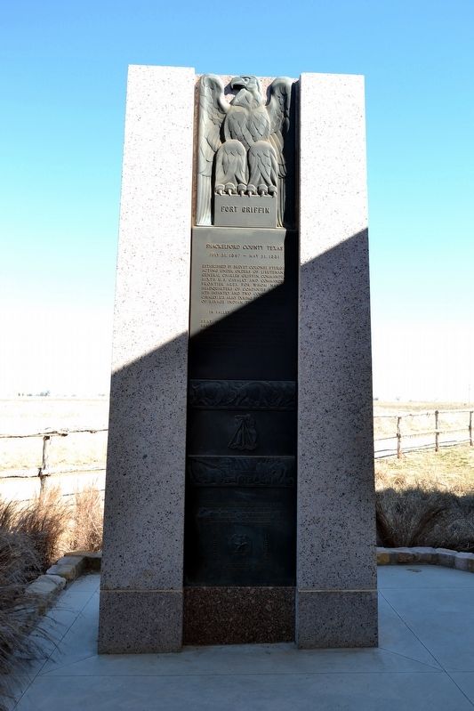
Established by Brevet Colonel Sturgis acting under orders of Lieutenant General Charles Griffin, Commander Sixth U.S. Cavalry and Commander Frontier Area, for whom named. Headquarters of Companies A, F, & G, 11th Infantry and two companies 4th . . . — — Map (db m101560) HM
On County Road 184 0.6 miles west of U.S. 283, on the left when traveling west.
Cattle have been important to Texas’ economy since early Spanish mission days. Before and after the Civil War, routes developed for driving herds through Texas to sell in Missouri and Kansas. The best known was the Eastern, or Chisholm Trail, but . . . — — Map (db m93643) HM
Near S. 2nd Street (State Highway 6) at S. Main Street (U.S. 283), on the right when traveling east.
Physician and military commander, Jack Shackelford, was born in Richmond, Virginia. He earned an M.D. degree and in 1811, moved to Winnsboro, South Carolina, where he opened his first practice and met Maria Youngue, whom he married. Shackelford . . . — — Map (db m85600) HM
On S. Main Street (U.S. 283) at S. 2nd Street, on the right when traveling north on S. Main Street.
Commemorating
First Producing Oil Well
In
West Texas
The Texas Company - J.E. Wild A 1
Survey 65, University Lands
Shackelford County
Completed Nov. 9, 1913
Presented to
The Texas Company
By
Texas Mid-Continent Oil and Gas . . . — — Map (db m85638) HM
On 4th Street 0.1 miles west of Oak Street, on the left when traveling west.
In Commemoration of the Organization Under This Oak by 40 Men of the Cattle Raisers Association of Texas on February 15-16, 1877
Its First Officers Were: C.L. Carter, President J.D. Smith, Vice President J.C. Loving, Secretary S.J. . . . — — Map (db m241030) HM
On U.S. 82 at Farm to Market Road 2591, on the right when traveling west on U.S. 82.
In Sep. 1871, Col. Ranald S. Mackenzie and the 4th U.S. Cavalry received permission to lead an expedition from Fort Griffin (Shackelford County) and engage Comanche who had refused to move to their designated reservation at Fort Sill (Oklahoma . . . — — Map (db m168639) HM
On County Road 184 0.6 miles west of U.S. 283, on the left when traveling west.
In the 19th century, the U.S. government established forts along Texas’ frontier to protect pioneers. By the early 1850s, Col. Jesse Stem farmed along the Clear Fork of the Brazos River, and Thomas Lambshead established his Clear Fork farm. As . . . — — Map (db m93641) HM
On West Central Avenue west of South 9th Street, on the right when traveling west.
Surveyed in 1850 by Army engineers, this was the first wagon road to penetrate this area. Point of origin was San Antonio, site of U.S. Army District Headquarters after annexation of Texas in 1846.
This segment of road extended from Fort . . . — — Map (db m308381) HM
The Civilian Conservation Corps (CCC) operated nationwide between 1933 and 1942 to conserve natural resources and to provide work for young men during the Great Depression. The Federal program provided employment for 2.5 million young men working . . . — — Map (db m101585) HM
Near Farm to Market Road 2408 1.3 miles east of State Highway 6.
Born in Ashtabula County, Ohio in April 1852, Granville Eades Waters came to Texas in 1871. He settled in the north central part of the state before moving to Shackelford County in 1876. The next year, he wed Rennie Harris, daughter of a Waco mayor. . . . — — Map (db m80130) HM
Born on September 15, 1839 in Mason County, Kentucky on the plantation of Benjamin Gratz, Lawson Gratz worked as a farmer for his owner prior to the Civil War. Lawson was directed by his owner to enlist in the Federal army on July 24, 1864 at . . . — — Map (db m189460) HM
Near S. 2nd Street (State Highway 6) at S. Main Street (U.S. 283), on the right when traveling east.
The highest ranking serviceman from Shackelford County during World War II, Robert Williams was a native of Albany. After attending schools here, he graduated from Texas A&M in 1923 with a degree in Civil Engineering and a commission as a Second . . . — — Map (db m85585) HM
On S. Jacobs Street north of S. 1st Street, on the left when traveling north.
First permanent home in Albany. Built 1875 of stone from nearby deposits by Henry Carter Jacobs (1842-94), an organizer and the first sheriff of Shackelford County. A Kentuckian, Civil War veteran, and surveyor, Jacobs platted town of Albany, . . . — — Map (db m94069) HM
On Vinson Road (County Road 114) 0.9 miles east of Farm to Market Road 1750, on the left when traveling east.
Founded in 1881, the city of Abilene became a regional economic center, yet civic boosters believed that the discovery of oil and gas in the area had the potential to advance the area’s economy and population even further. Significant oil . . . — — Map (db m77768) HM
On State Highway 16 0.2 miles south of Farm to Market Road 8, on the left when traveling south.
A few miles to the southwest. Largest far western "Family Fort" used throughout Civil War. Started by C.C. Blair, 1857 settler. 1861-1865 occupants were Wm. Arthur, Blair, J.M. Ellison, Jasper, Jim and Tom Gilbert, W.C. McGough, W.H. Mansker and . . . — — Map (db m181883) HM
On N. Jacobs Street at N. 2nd Street, on the right when traveling south on N. Jacobs Street.
Oldest congregation in Northwest Texas Conference of Methodist Church. First church of any denomination founded in Shackelford County. Organized in 1873 at ranch home (8 mi. E) of J.C. Lynch (1828-1912), a later county judge, after Shackelford was . . . — — Map (db m94024) HM
Near S. Main Street (U.S. 283) at S. 2nd Street, on the right when traveling north.
First inhabited by nomadic Indian tribes, Shackelford County was created in 1858 and named for Dr. John Shackelford (1790-1857). The first permanent Anglo-American settlers in this area included J.C. Lynch (1828-1912), a native of Ireland who moved . . . — — Map (db m85633) HM
On Park Road 54 0.5 miles east of U.S. 283, on the left when traveling east.
(Front Side)
Few in numbers and with little protection from the military but refusing to abandon their country, certain families of courageous and determined people on the Texas frontier during the Civil War gathered together in hastily . . . — — Map (db m93646) HM
On Farm to Market Road 604 2.4 miles east of U.S. 84, on the left when traveling east.
At the height of Cold War tensions between the United States and the Soviet Union, development of intercontinental ballistic missiles (ICBMs) with nuclear warheads embodied military might. Convair's Atlas missile program, selected by the U.S. Air . . . — — Map (db m239792) HM
Thin black lines indicate changes in relevance. Between each pair of lines entries are ordered geographically but all have the same relevance.
* Inflectional forms of words are their plurals, singulars, and possessives as well as gramatical tenses and similar variations.