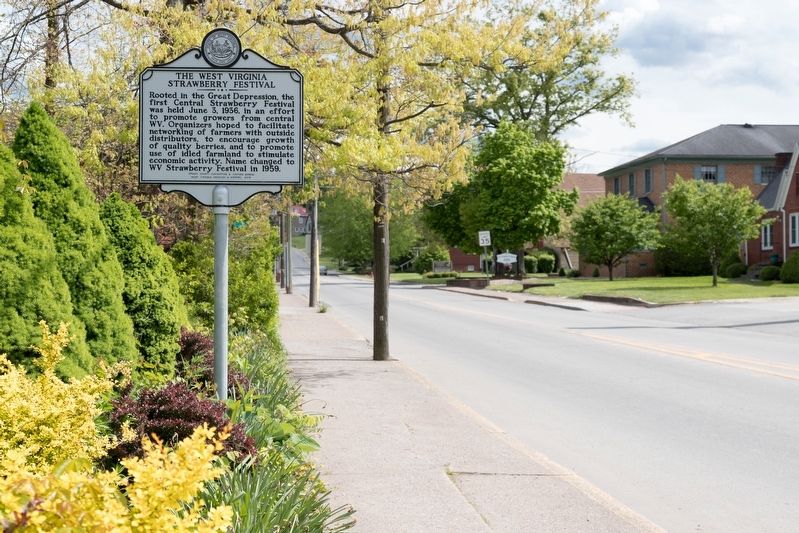
On South Kanawha Street (West Virginia Route 20) at West Lincoln Way, on the right when traveling south on South Kanawha Street.
Rooted in the Great Depression, the
first Central Strawberry Festival
was held June 3, 1936, in an effort
to promote growers from central
WV. Organizers hoped to facilitate
networking of farmers with outside
distributors, to encourage . . . — — Map (db m173489) HM
On South Spring Street north of Madison Street, on the right when traveling north.
Create Buckhannon has chosen to honor two members for their contributions to Festival Fridays hosted right here in Jawbone Park each summer. Festival Fridays and Upshur County are not the same without Jerry Kimble and Jim Farrell.
Jerry . . . — — Map (db m267095) HM
On Baxter Street at Warfield Way, on the left when traveling east on Baxter Street.
Charles William Warfield, Sr. was born on December 8, 1870 in Harpers Ferry, West Virginia. He was the second child of James Oscar & Elizabeth (née Robinson) Warfield. Not much is known about his childhood. He married Mary Margaret (née Crane, . . . — — Map (db m267749) HM
On Rock Cave Road (West Virginia Route 4) at Route 20, on the right when traveling north on Rock Cave Road.
It is doubtful that residents of Upshur County that month of September, '63, were paying much attention to events within the legislative halls. The county instead was mourning the greatest calamity that would befall Upshur in the Civil War--a . . . — — Map (db m282818) HM
On North Locust Street (West Virginia Route 20) at West Main Street (County Route 151), on the right when traveling north on North Locust Street.
This mural was designed & painted by deborah dorland of Richwood WW in the summer of 2006 and is based on the city seal of Buckhannon (est. 1816, inc. 1852) created by local artist Ross Straight in 1998. The seal depicts an imagined meeting . . . — — Map (db m267819) HM
On Madison Street near South Florida Street, on the left.
Wilbert H. Grubb is the only City of Buckhannon police officer ever killed in the line of duty. Officer Grubb was born in Upshur County on February 19, 1894, the son of Columbus Lee & Malinda Elizabeth Zickefoose Grubb. Officer Grubb was a proud . . . — — Map (db m267216) HM
On Buckhannon Pike (old U.S. 33) (West Virginia Route 151) at Lantz Road (County Route 13), on the left when traveling south on Buckhannon Pike (old U.S. 33).
Upshur County. Formed in 1851 from Lewis, Barbour, and Randolph. Named for Abel Parker Upshur, the great Virginia statesman. Samuel and John Pringle were the first settlers in 1764, and later they guided other pioneers here.
Randolph . . . — — Map (db m179503) HM
On East Main Street (County Road 151) just east of North Kanawha Street, on the right when traveling west.
Trading much of the southern portion of Staten Island for 3,500 acres of land in western Virginia, Daniel Farnsworth moved west and in the summer of 1821 settled on the banks of the Buckhannon River with his wife and five sons. Leonard Farnsworth, . . . — — Map (db m179007) HM
On Camden Avenue north of Walktrail Lane, on the left when traveling north.
Where West Virginia Wesleyan College has its baseball field and football practice field, was the site of the William Flaccus Oak Leather Company. On this site, the William Flaccus Oak Leather Company of Pittsburgh, Pennsylvania, operated a larger . . . — — Map (db m267463) HM
On West Main Street (County Route 151) at Locust Street ( Highway 20), on the right when traveling east on West Main Street.
Confederate Gen. Albert G. Jenkins led 550 cavalrymen on a 500-mile raid from Salt Sulphur Springs, Aug. 22-Sept. 12, 1862, attacking Federal forces and destroying military stores. He captured and paroled 300 Union soldiers, killed or . . . — — Map (db m58723) HM
On East Main Street (County Route 151) just east of North Kanawha Street, on the right when traveling west.
Explorations of West Blue Ridge
It is impossible to say when and where the first European settlers set foot on the soil of what is now West Virginia. In all probability no record was ever made of the first visit. It is well known that . . . — — Map (db m179016) HM
On Camden Avenue north of Walktrail Lane, on the left when traveling north.
Robert J. "Bob" Wallace was appointed as Buckhannon's City Attorney in 1958. Bob counseled our city for decades, & during his long tenure it was no coincidence that Buckhannon emerged as one of the finest communities with one of the highest . . . — — Map (db m268053) HM
On Park Street at Gum Street, on the right when traveling south on Park Street. Reported damaged.
(Preface): In the spring of 1861, Union forces rushed into northwestern Virginia to secure the vital Baltimore and Ohio Railroad, protect important turnpikes, and support Unionists against Confederates. The two sides fought numerous . . . — — Map (db m58724) HM
On Mud Lick Road (County Route 5/7) at Old Weston Road (County Road 12), on the right when traveling north on Mud Lick Road.
On April 20, 1863, Confederate Gens. William E. “Grumble” Jones and John D. Imboden began a raid from Virginia through present-day West Virginia against the Baltimore and Ohio Railroad. Taking separate routes, they later reported that they . . . — — Map (db m58722) HM
Near Camden Avenue north of Walktrail Lane, on the left when traveling north.
Family: Anacardiaceae (Cashew Family)
Distribution: Our eastern poison ivy grows throughout eastern North America, up through Quebec and Ontario and west into Texas and Oklahoma. It is found in most of West Virginia's counties and can be . . . — — Map (db m272410) HM
On Madison Street east of South Florida Street, on the left when traveling east.
On Monday night, August 1st, 1921, Mister A.C. Westfall of Buckhannon, had his car stolen from his yard on East Main Street. Descriptions of the car were sent to various departments across the state, yet no leads were found until a store in . . . — — Map (db m267212) HM
On Hall Road (County Route 13) south of Weatherford Boulevard, on the left when traveling south.
On April 27, 1942, unto his mother, Nela (1916-91) & his father, Fleming (1911-64) brown, was born & reared in Upshur County, a true American hero, Larry Brown. Mr. Brown attended Buckhannon-Upshur High School, & enlisted in the U.S. Marine Corps . . . — — Map (db m267929) HM
On East Main Street (County Road 151) at Traders Alley, on the right when traveling east on East Main Street.
Charley Harper was born in neighboring Frenchton, Upshur County, West Virginia on August 4, 1922, the son of Orval Cecil Harper (1888-1958) & Ulna N. Harper (1889-1977). He was one of three children, who with sisters, Ruth & Reta, grew up on the . . . — — Map (db m178942) HM
Near Main Street north of Rices Landing Road (County Route 1010), on the left when traveling north.
River Formation
Prior to the glaciers (more than 780,000 years ago), the ancestral Monongahela River flowed from present day north central West Virginia across Pennsylvania and northwest Ohio. Extensive ice sheets dammed the old north . . . — — Map (db m230986) HM
Near State Park Road 1.1 miles north of U.S. 19, on the left when traveling north.
The Stonewall Dam is located on the West Fork River, three miles south of the county seat at Weston, West Virginia and 73 miles upstream from the river's mouth. From its source in Lewis and Upshur Counties, the West Fork River flows northward for . . . — — Map (db m281310) HM
On Coal River Road (West Virginia Route 3) just north of Bridge Avenue, on the right when traveling north.
1907 Fairmont Coal Company
Monongah No. 6 and No. 8 Mines
Monongah, West Virginia
At 10:20 a.m., December 6, 1907, explosions occurred at the No. 6 and No. 8 mines at Monongah, West Virginia. The explosions ripped through the mines, . . . — — Map (db m285301) HM
On Veterans Memorial Highway (West Virginia Route 7) at Alpine Lake Road (County Route 46), on the right when traveling west on Veterans Memorial Highway.
Barbour County
Attractions
Alderson-Broaddus College. This private coeducational college is situated on a beautiful 170-acre campus overlooking Philippi, site of the first land battle of the Civil War. Its excellent performing arts . . . — — Map (db m239336) HM
Thin black lines indicate changes in relevance. Between each pair of lines entries are ordered geographically but all have the same relevance.
* Inflectional forms of words are their plurals, singulars, and possessives as well as gramatical tenses and similar variations.