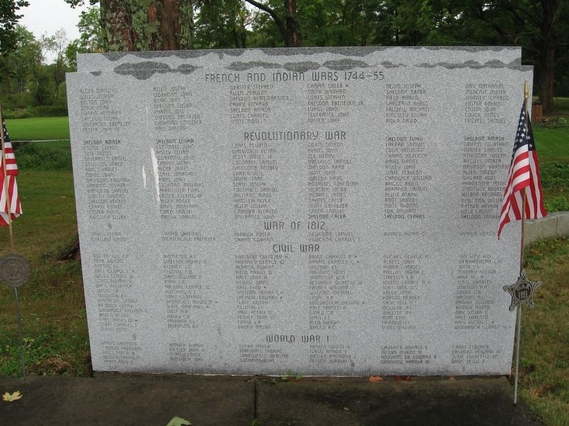
On Church Street (Massachusetts Route 10) at South Street ( Route 5), on the left when traveling west on Church Street.
Dedicated To The
Bernardston Men And
Women Who Have Served
Their Country Honorably
(left panel)
French and Indian Wars 1744-55
Alger, Waitstill • Wells, Joshua • Bolton, John • Smith, Noah • Chapin, Hezekiah • Sheldon, Elijah . . . — — Map (db m98189) WM
On Bernardston Road (U.S. 5), on the right when traveling north.
Six rods easterly stood Burke Fort the first and largest, and also the first building in Fall Town. Built in 1738/39 by John Burke it was six rods square and contained eight houses. Fifty persons took shelter here during the old French and Indian . . . — — Map (db m48254) HM
On Brattleboro Road (U.S. 5), on the left when traveling north.
Site of the second fort and building in Fall Town, erected in 1739 by Samuel Connable. Its original timbers are still in the house on a knoll to the northwest. — — Map (db m48774) HM
On Huckle Hill Road close to West Road, on the right when traveling north.
The Lieutenant's son Ebenezer, later deacon of the church and first town treasurer, built a fort ten rods east of here in 1740/41. It was unsuccessfully attacked by Indians in 1746 during King
George's War. — — Map (db m48777) HM
On Northfield Road (U.S. 10), on the right when traveling west.
Built in 1740 on this site. The first Proprietor's Meeting in Fall Town was held here in 1741. The Lieutenant's son Eliakim was shot by Indians in 1747 while working west of the fort walls. — — Map (db m48011) HM
On Mohawk Trail (Massachusetts Route 2) at Tower Road, on the left when traveling north on Mohawk Trail.
In memory of the
Mohawk Indian
The Mohawks of the Five Nations began to settle in New York state in 1590, and for 90 Great Suns they fought the New England tribes. The New York Mohawks that traveled this trail were friendly to . . . — — Map (db m198080) HM
On Main Street (Massachusetts Route 2) at N Heath Road ( Route 8A), on the right when traveling west on Main Street.
In memory of the men and women of Charlemont who proudly served in the
Armed Forces of the United States, around the world from 1950 to 1999 A.D.
Albee, John C. •
Angell, Leo S. •
Annear, Cyrus C., Jr. •
Atwater, John M. •
Avery, . . . — — Map (db m279825) WM
On Main Street (Massachusetts Route 2) near N Heath Road ( Route 8A), on the right when traveling west.
Honor Roll
Erected by
the Town of Charlemont
to the memory of
the men who served their country
1861 – in the Civil War – 1865
Albee, Henry M. •
Avery, Francis D. •
Avery, H. G. •
Avery, John D. •
Barnard, Edward • . . . — — Map (db m279943) WM
On Main Street (Massachusetts Route 2) west of N Heath Road ( Route 8A), on the right when traveling west.
Honoring combat veterans of
the Korean and Vietnam wars
Korea
Albee John C. •
Avery, William B. •
Lamore, Gilmond •
Maynard, Albert E. •
Noga, Henry C. •
Russell, Edward P. •
Tinney, Lawrence S., Jr. •
Werner, Lawrence • . . . — — Map (db m279947) WM
On Main Street (Massachusetts Route 2) near N. Heath Road, on the right when traveling west.
Honor Roll
This tablet is erected by
the Town of Charlemont
as a tribute to the men who served
1917 – in the World War – 1919
★ Coyne, Patrick J. Killed in Action
★ Woodward, Guy Died in . . . — — Map (db m279939) WM
On Main Street (Massachusetts Route 2) west of N Heath Road ( Route 8A), on the right when traveling west.
Honor Roll
erected by
the town of Charlemont
to the memory of
the men who served their country
1941 in World War II 1945
Angeli, Jino ·
Augustowski, Frank ·
Avery, Alton ·
Avery, Burton W. ·
Avery, Henry L. Jr. . . . — — Map (db m280309) WM
On Mohawk Trail (Massachusetts Route 2), on the right when traveling east.
To the Thrifty Travelers of the Mohawk Trail who in 1797 here forded the Deerfield River rather than pay toll at the Turnpike Bridge and who in 1810 won the battle for free travel on all Massachusetts Roads. — — Map (db m51444) HM
On Mohawk Trail (Massachusetts Route 2) east of Burrington Road, on the right when traveling west.
The home was shared by Roger (President, Franklin County Anti-Slavery
Society 1836, Vice President Massachusetts Anti-Slavery Society 1838-39)
and Chloe Maxwell Leavitt, parents of Roger Hooker.
The site was a safe house from 1838-1844 for . . . — — Map (db m280353) HM
Near Old Main Street north of Academy Lane, on the right when traveling south.
Some of the world's best soil is right here in the Connecticut River Valley.
The valley's soil made it a location of choice for the Pocumtuck and other Indian peoples who cultivated native maize (corn), beans, squash and tobacco. English . . . — — Map (db m230713) HM
On Old Main Street north of Academy Lane, on the right when traveling north.
Museum admission tickets available at the Visitor Center.
• Built 1734.
• Home of museum founders Henry and Helen Geier Flynt, 1945-1975.
• Restored interiors reflect the Flynts' lifestyle during their heyday of collecting American . . . — — Map (db m230695) HM
On Old Main Street south of Broughams Road, on the right when traveling south.
Museum admission tickets available at the Visitor Center.
• Built 1734, with alterations.
• Home of Deerfield's second minister.
• Furnishings of the Connecticut River Valley elite. — — Map (db m230672) HM
On Old Main Street at Boyden Lane, on the right when traveling north on Old Main Street.
Museum admission tickets available at the Visitor Center.
• Built 1795.
• Site of Deerfield Academy's first trustees meeting in 1797.
• Operated as a tavern until 1805 at the crossroads of travel between Boston, MA; Albany, NY; Hartford, . . . — — Map (db m230746) HM
On Memorial St 0.1 miles east of Old Main St, on the right when traveling west.
Benjamin Barrett
-Carpenter -
Born 1653 – Died 1690
Soldier with Captain Turner 1676
Settled on Plum Tree Plain Deerfield 1684
Owner of this home Lot No. 27 when he died 1690
This memorial is erected by his lineal . . . — — Map (db m266706) HM
On Old Main Street south of Broughams Road, on the right when traveling south.
Cato, c. 1737 - 1825, son of Jin Cole, enslaved as a child in this house.
Jin Cole, c. 1723 - 1808, captured in Africa at age 12, enslaved in this house.
Titus, 1751, enslaved in this house. — — Map (db m230670) HM
Near Old Main Street south of Main Street, on the right when traveling north.
This Three Sisters Garden is a good example of the ecological benefits of growing certain plants together. As the corn grows, the beans will naturally find the support they need by climbing up the tall stalks. At the same time, the roots of the bean . . . — — Map (db m230693) HM
Near Old Main Street north of Academy Lane, on the right when traveling north.
This interpretive garden is dedicated to the loving memory of Margaret Quinn Orloske, a fellow gardener and hearth cook, and to the eternal spirit of the thousands who died with her on September 11, 2001. The Margaret Quinn Orloske Endowment Fund . . . — — Map (db m230743) WM
On Main St at Old Main Street, on the left when traveling west on Main St.
Where Mohawk struck Pocumtuck pride,
Sentinel stalks of Indian corn
Still guard the Meadow of our world:
The sad silence of grass-grown graves
A frontier home on the falling ridge
And a cold gray February dawn.
All of America . . . — — Map (db m141333) HM
On Old Main Street 0.1 miles north of Albany Road, on the left when traveling north.
In Grateful Appreciation
of the Patriotism and self Sacrifice
of Her Lamented Sons and Soldiers,
Who for Their Country and for Freedom
Laid Down Their Lives in the War
of the Great Rebellion,
Deerfield
Erects This Monument
A.D. . . . — — Map (db m141862) WM
On Albany Rd at Old Main Street, on the left when traveling north on Albany Rd.
Feb 29, 1703-4
The unfortified house of Benoni Stebbins
standing on this lot was held by
7 men besides women and children
for three hours
against the assault of 200 soldiers
and the wiles of 140 Indians.
under a French . . . — — Map (db m141156) HM
Near Old Main Street north of Academy Lane, on the left when traveling north.
The indoor comforts of home were provided by outdoor work on the farm.
Bordered by house, garden, outbuildings, and fields, the farm yard has always been a busy crossroads of activity now and in the past. Farm families of the 1800s managed . . . — — Map (db m230696) HM
Near Old Main Street near Academy Lane, on the left when traveling north.
During the last ice age, a glacier one-mile thick towered over the spot where you are standing. When it began to melt about 16,000 years ago, the water backed up in the valley creating a giant lake 220 miles long. Early geologists named it Lake . . . — — Map (db m230715) HM
On Old Main Street at Albany Road, on the right when traveling north on Old Main Street.
Museum admission tickets available at the Visitor Center.
• Built about 1760, with alterations.
• Restored in 1892 by preservationist Charlotte Alice Baker.
• Furnishings reflect her interest in the Colonial Revival and the Arts and . . . — — Map (db m230744) HM
On Old Main Street south of Main Street, on the right when traveling north.
Museum admission tickets available at the Visitor Center.
• Built in 1824, by Asa Stebbins for his son, Asa, Jr.
• Gilded fanlight details over the front door became popular in the early 19th century.
• Connecticut Valley Furniture . . . — — Map (db m230686) HM
On Memorial St 0.1 miles east of Old Main St., on the right when traveling west.
Ancestor of all the name of Nims. Settled in Deerfield 1674. Fought under Capt. Turner 1676. Bought this home lot 1692. His house burned, his wife and seven children captured or killed by Indians in 1704. This New Hampshire boulder was erected by . . . — — Map (db m141115) HM
Near Old Main Street south of Main Street, on the right when traveling north.
Welcome. This living exhibit interprets a Native American agricultural method of companion-planting three crops called the Three Sisters: corn (maize), beans, and squash. Growing these three plants together is very labor efficient, . . . — — Map (db m230691) HM
On Old Main St 0.3 miles north of Albany Rd, on the left when traveling north.
The Village of Deerfield is an old settlement on an ancient site.
The Mile-long street before you was originally a Native path. Ancestors of the Pocumtuck, an Algonquin people, lived here in their homeland for at least 8,000 years, . . . — — Map (db m141346) HM
On Old Main St 0.2 miles north of Albany Rd, on the left when traveling north.
Home of Joseph Stebbins
Born 1749 Died 1816
Lover of Liberty
And
Servant of His Country
__________
Lieutenant of Minute Men
Who Marched on the Lexington Alarm
Captain at the Battle of Bunker Hill
Fought at Stillwater . . . — — Map (db m141334) WM
On Old Main St 0.1 miles north of Albany Rd when traveling north.
John Sheldon 1658 - 1733
Hannah Stebbins 1664 – 1704
Married Nov 5 1679
The Home Of John Sheldon Was On This Lot
Here Feb 29 1704 His Wife And One Child Were Killed
And Four Children Were Taken Captive
By The . . . — — Map (db m143814) HM
On Old Main St 0.2 miles south of Broughtons Pond Rd, on the left when traveling south.
This Marks the Home Lot where
John Stebbins
Grandson of Rowland the Emigrant
A Permanent Settler of 1652
Lived and Died
__________
A Soldier under Capt. Lothrop
The Only Man Known who Escaped Unhurt
At the Bloody Brooke . . . — — Map (db m141336) HM WM
On Old Main Street at Memorial Street, on the right when traveling north on Old Main Street.
Lucy Terry Prince, c. 1729 - 1821. Captured in Africa as a child. Enslaved in this house. Died a free woman in Vermont.
Caesar, baptized 1734. Enslaved in this house. — — Map (db m230747) HM
On Memorial St 0.1 miles east of Old Main St, on the right when traveling west.
Memorial Hall
Built in 1798
Occupied as Deerfield Academy
Until 1878
Dedicated in 1880 to the
Preservation of the Record of
Early Days in New England
by the
Pocumtuck Valley Memorial Association
This Tablet is Erected on . . . — — Map (db m141125) HM
Near Old Main Street north of Academy Lane, on the left when traveling north.
The interplay of people and nature has shaped this place for generations.
The living things that populate our landscape are part of a continual process of change. Long ago, the Pocumtuck cleared forests of underbrush and set controlled . . . — — Map (db m230720) HM
Near Old Main Street south of Main Street, on the right when traveling north.
The foods we eat directly affect our health. Eating squash, corn, and beans together offers greater health benefits than eating them separately. Consuming corn and beans during a meal provides a high-quality source of protein equal to that found in . . . — — Map (db m230694) HM
On Old Main Street near Wells Street, on the left when traveling north.
Indian land called Pocomtuck, settled by men from Dedham in 1671. Attacked by Indians, burnt, and abandoned in 1675. Reoccupied and attacked in 1704 by French and Indians, who took 47 lives, and carried off 112 captives to Canada, of whom 60 were . . . — — Map (db m48773) HM
On Greenfield Road (U.S. 5) north of Main Street, on the right when traveling north. Reported permanently removed.
Indian land called Pocomtuck, settled by men from Dedham in 1671. Attacked by Indians, burnt, and abandoned in 1675. Reoccupied and attacked in 1704 by French and Indians, who took 47 lives, and carried off 112 captives to Canada, of whom 60 were . . . — — Map (db m288313) HM
On Old Main St 0.2 miles north of Albany Rd, on the left when traveling north.
Old Deerfield Village
has been Designated A
Registered National
Historic Landmark
Under the provisions of the
Historic Sites Act of August 21, 1935
this site possesses exceptional value
in commemorating and illustrating
the . . . — — Map (db m141339) HM
On Albany Road at Old Main Street, on the left when traveling north on Albany Road.
Site of the
Old Indian House
Built by
Ensign John Sheldon 1698
It stood for 144 years
testifying to the tragedy of
Feb. 29, 1703
its stout door
which kept at bay
the French and Indians
13 now safe in Memorial Hall . . . — — Map (db m141341) HM WM
Near Old Main Street north of Academy Lane, on the left when traveling north.
The Connecticut River Valley is a distinctive geographic region in the Northeast.
This beautiful landscape and its irreplaceable balance of farms, fields, hills and forests conveys a potent sense of place that points to a sustainable . . . — — Map (db m230718) HM
On Main St 0.1 miles north of Albany Rd, on the right.
Erected In Memory of
Quinton Stockwell
and his wife
Abigail Bullard Stockwell
It was in their house, which stood on
this spot, that the Stockwells boarded
the Reverend Samuel Mather during the
earliest days of . . . — — Map (db m147359) HM
On Old Main Street north of Academy Lane, on the left when traveling north.
Original house built by Ensign John Sheldon on 1698. Withstood attack by French and Indians on the night of Feb. 29, 1704. Torn down in 1848. — — Map (db m230727) HM
On Old Main St 0.1 miles south of Albany Rd, on the right when traveling north.
In Memory Of
Rev. Samuel Mather. M.A.
Pioneer Minister of Deerfield 1673 – 75.
Who lived in a house on this site.
Born at Dorchester, 1650. Graduated Harvard College 1671.
Married Hannah, Daughter of Governor Robert Treat
Of . . . — — Map (db m141956) HM
Near Old Main Street north of Academy Lane, on the right when traveling north.
The Deerfield and Connecticut Rivers shape the geography, economy and culture of this region.
Through the trees to the west you can see a dramatic curve, or oxbow, of the Deerfield River. From its headwaters in Vermont's southern Green . . . — — Map (db m230722) HM
On Old Main Street south of Broughams Road, on the right when traveling south.
Built by John Sheldon 1739. Handed down from sire to son to the present owner.
The longest holding of state in Franklin County. — — Map (db m230688) HM
On Old Main Street south of Broughams Road, on the right when traveling south.
Museum admission tickets available at the Visitor Center.
• Built 1755.
• Georgian period architecture.
• Furnishings reflect the life of a farming family, 1780 - 1810. — — Map (db m230690) HM
On Old Main Street north of Academy Lane, on the right when traveling north.
Museum admission tickets available at the Visitor Center.
• Built 1799.
• Deerfield's first brick house.
• Federal period architecture and furnishings, 1790-1830. — — Map (db m230731) HM
On U.S. 5 at Main Street, on the right when traveling south on U.S. 5.
2nd Lt Thomas W. Johnson, U.S. Army Air Corp, ★ KIA ~ April 29, 1944 ~ Germany ~ WWII ★
LT Allan J. Johnson, U.S. Army Air Corp, ★ KIA ~ April 24, 1944 ~ Germany ~ WWII ★ — — Map (db m230668) WM
On Old Main Street north of Academy Lane, on the right when traveling north.
Historic Deerfield is a museum of early New England history and the arts located within one of New England's most historic villages. Visitors come here to tour our museum collections and the carefully preserved old houses in which they are . . . — — Map (db m230732) HM
On Old Main Street south of Memorial Street, on the right when traveling north.
Museum admission tickets available at the Visitor Center.
• Built 1747.
• First painted blue in 1802.
• Interior furnishings illustrate change through time, 1725 to 1850. — — Map (db m230749) HM
On Old Main Street, on the right when traveling south.
Here stood the palisaded house
of
Captain Jonathan Wells
to which those
escaping the fury of the savages
fled for safety Feb. 29, 1704
Jonathan was the
boy hero of the Connecticut Valley
1676 and
commanded in the Meadow Fight . . . — — Map (db m267194) HM
On Mohawk Trail (Massachusetts Route 2), on the right when traveling west.
A special place designated by the Massachusetts Executive Office of Environmental Affairs because it exemplifies the unique qualities of the Commonwealth. — — Map (db m2642) HM
On Riverview Drive just south of Pine Street, on the right when traveling south.
Riverside Village Historic District has been placed on the National Register of Historic Places in 2017 by the United States Department of the Interior — — Map (db m230570) HM
On Main Street (Massachusetts Route 2A) just west of School Street, on the right when traveling west.
Earliest commercial structure, built in 1812 by Jonathan Bird, was two stories tall until 1874, when expanded in Queen Anne style. — — Map (db m230577) HM
On Conway Street at Silver Street, on the right when traveling south on Conway Street.
A military commander during King Phillip's War. Capt. Turner was killed near here in a retreat after leading a massacre of Indians fishing at the Great Falls of the Conn. River in Gill on May 19, 1676. — — Map (db m299224) HM
On Main Street (Massachusetts Route 2A) at Davis Street, on the right when traveling east on Main Street.
In honor of the men who enlisted from the Town of Greenfield, Mass.
to serve their country in the War for the Union
1861 - 1865
Agin, Thomas 20th Inf. •
Allen, Chas. 52nd Reg't. •
Allen, Franklin 34th Inf. •
Allman, Samuel 57th Inf. . . . — — Map (db m231103) WM
On Eunice Williams Drive 0.5 miles Leyden Road, on the left when traveling west.
Eunice Williams, wife of the Reverend John Williams "The Redeemed Captive," was killed at this place on March 1, 1704, during the Deerfield massacre. — — Map (db m29069) HM
An original industrial area of Greenfield and site of mills from 1784. In four story granite factory buildings built in 1830 woolens were made for union army during Civil War. Operations ceased in 1872 and factory burned in 1933. The bell tower . . . — — Map (db m65769) HM
On Main Street (Massachusetts Route 2A) at Bank Row (U.S. 5), on the left when traveling west on Main Street.
Greenfield
erects this monument
in grateful honor to her
patriotic sons
who offered their lives
in suppressing the Great Rebellion
and for the preservation of the
National Union.
1861-5 — — Map (db m198091) WM