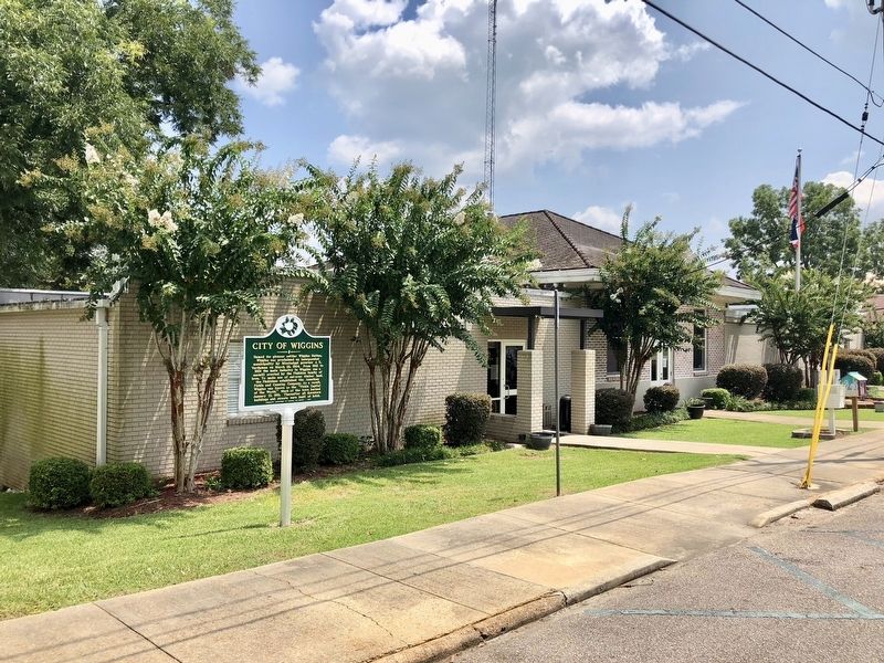
On First Street North north of East College Avenue, on the right when traveling north.
Named for pioneer settler Wiggins Hatten,
Wiggins was proclaimed an incorporated
municipality by Mississippi governor J. K.
Vardaman on March 26, 1904. From 1902 to
1929 the main industry in Wiggins was a
sawmill erected by the Finkbine . . . — — Map (db m122362) HM
On State Highway 29 near Flint Creek Water Park entrance, on the left when traveling north.
The Flint Creek Post Office was established in
the early 1840s and was the only post office
in the Piney Woods between Augusta and the
Gulf Coast before the Civil War. First located
on Flint Creek three miles north of present day
Wiggins, it . . . — — Map (db m196851) HM
On South Magnolia Drive (Mississippi Route 29) at East Pine Avenue, on the right when traveling north on South Magnolia Drive.
As early as 1837, attempts were made to
build the Gulf & Ship Island Railroad.
It was finally completed from Gulfport to
Hattiesburg by Buffalo, New York,
financier Joseph T. Jones in October
1896. Commercial operations began on
January . . . — — Map (db m122364) HM
On First Street North north of North 1st Street, on the right when traveling north.
Following the fire of January 21, 1910,
in downtown Wiggins, Gulf and Ship Island
Railroad officials replaced the two-story,
wooden depot lost lo the blaze with a
one-story wood frame structure. In the
late 1990s, when the Kansas City . . . — — Map (db m122363) HM
On City Bridge Road 0.9 miles south of Highway 26, on the right when traveling south.
In 1912, four rural schools, located in the
Hope, Odom, Marion, and Ena communities,
were consolidated to form the H.O.M.E.
school. The next year, 173 students in ten
grades relocated to the three-story Big
Level School. In 1927, that school . . . — — Map (db m197263) HM
On U.S. 49 at Perkinston-Silver Run Road (Main Street), on the right when traveling south on U.S. 49.
In 1860, John Perkins, his wife, and their two daughters lived in a square~timber cabin located on a hill one~tenth of a mile to the northeast. By the mid~1890s a small community formed here, with the Gulf and Ship Island Railroad depot and post . . . — — Map (db m109200) HM
On New Hope Road 0.6 miles south of Shadeville Road, on the right when traveling south.
Born a slave, John Wesley "Wes” Fairley
served with the 74th U.S. Colored Troops during
the Civil War. While guarding Confederate
prisoners on Ship Island, Fairley recognized
Lorenzo N. Dantzler, a white acquaintance from
home, and protected . . . — — Map (db m196845) HM
On U.S. 49 at East McHenry Road, in the median on U.S. 49. Reported missing.
Grave 4 mi. S.W. Pioneer of South Mississippi. Captain in War of 1812, 1813-15. Lt. Col. militia & member territorial legislature, 1815, 1817. State legislator, 1838, 1839. — — Map (db m97108) HM
On McHenry School Drive 0.1 miles south of West McHenry Road, on the right when traveling south.
In 1889 George Austin McHenry led fifty-four families from Michigan to a site on the proposed route of the Gulf and Ship Island Railroad twenty-five miles north of Gulfport. This "Michigan settlement," later known as McHenry, flourished as a forest . . . — — Map (db m122361) HM
On East Central Avenue (State Highway 26) at Iowa Street, on the right when traveling east on East Central Avenue.
Born a slave on July 19, 1854, in North Carolina, Professor W.P. Locker became a highly respected educator in Stone County in the first quarter of the 20th century. In 1959, the Stone County Training School, built in 1955, was named in his honor. . . . — — Map (db m109198) HM
On Mississippi Route 15 0.7 miles south of Cut Off Road, on the right when traveling south.
Settled by the Ramsay family in 1820,
Ramsay Springs became a popular fishing,
camping, and hunting site as early as
1896. Development reached its peak with
the opening of the three-story, rustic
Ramsay Springs Hotel on May 12, 1923.
Other . . . — — Map (db m197262) HM
On North Azalea Drive (U.S. 49) 1.3 miles north of West Central Avenue (State Highway 26), on the left when traveling north.
Stone County was proposed by legislator Andrew Wiggins Bond and created from the north third of Harrison County during a May 8, 1916 vote. It is named for two~time Mississippi governor John Marshall Stone. The county seat, Wiggins, was established . . . — — Map (db m109217) HM
On Court Street at East Cavers Avenue, on the right when traveling north on Court Street.
Designed by architect Xavier Kramer, and
constructed by Standard Construction Co.
in 1917, this multi-storied Neo-Classical
building contains a large courtroom and
offices for county officials. A cultural
as well as legal center, the . . . — — Map (db m122369) HM
On State Highway 26 0.5 miles west of Old Highway 26, on the right when traveling west.
In 1848, James Harvey killed two members
of the Copeland Gang in a dispute over the
deed to his property on Red Creek. Seeking
revenge, James Copeland and three of his
men waited in ambush inside Harvey's cabin.
Aware of the ambush, Harvey and . . . — — Map (db m196175) HM
On Friendship Lane at King Bee Road, on the right on Friendship Lane.
Emilie and Marie Stapp were natives of Iowa,
where Emilie (1876-1962) began writing
children's books and Marie (1880-1960) worked
for a newspaper. After living in Boston, they
moved to Wiggins due to family ties to the
Finkbine Lumber Company. . . . — — Map (db m197340) HM