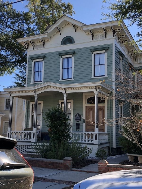
On Orange Street east of South 4th Street, on the right when traveling east.
Italianate style house built for William Iredell Gore (1829-1903), native of Brunswick County, captain in Company C, North Carolina 18th Infantry Regiment during the Civil War, wholesale grocer and commission merchant; and wife, Rachael Ann . . . — — Map (db m262776) HM
On Reedy Creek Road (County Road 634) north of Big Horn Road (County Road 633), on the right when traveling south.
By 1772, Zachariah Thompson, a Baptist minister based in North Carolina, had founded a church here on Reedy Creek. This is the oldest-continuing Baptist church in Brunswick County. Members later helped organize a number of other congregations in . . . — — Map (db m310194) HM
Near Caswell Beach Road 2.5 miles east of Oceangreens Lane.
1826: Construction Begins
Remainder of text unreadable.
1833: The Fort is Named
Remainder of text unreadable.
1836: A New Leader
Remainder of text unreadable.
1838: Project is Finished . . . — — Map (db m267419) HM
On River Road Southeast (North Carolina Route 133) 0.2 miles north of George II Highway Southeast ( Route 87), on the left when traveling north.
Maj. Gen. Howe was the
commander of Southern
Dept. of the Continental
Line, 1776-78, & N.C.'s
highest ranking officer.
Lived 4½ miles east. — — Map (db m267525) HM
On South Broad Street, on the right when traveling south.
Organized in March 1862 under the leadership of Capt. William Badham Jr., Lt. John M. Jones, and Lt. Nelson McClees, the Edenton Bell Battery was composed of men primarily from Chowan, Tyrrell, and Washington Counties. Lacking adequate artillery, . . . — — Map (db m34835) HM
Near Fort Fisher Boulevard South (U.S. 421) 0.1 miles north of Battle Acre Road, on the right when traveling south.
According to the Federal battle plan, 1,600 sailors and 400 marines were to attack the sea face of Fort Fisher, while 3,700 troops were to assault the land face. Admiral Porter described his plan as follows: "[T]he sailors will be armed with . . . — — Map (db m278945) HM
On Fort Hill Road 1.1 miles west of Christanna Highway (Virginia Route 46), on the right when traveling west. Reported permanently removed.
In 1714, at Governor Alexander Spotswood’s urging, the Virginia General Assembly funded the Virginia Indian Company, charged with building a fort on the banks of the Meherrin River in what would become Brunswick County. The fort would provide . . . — — Map (db m20197) HM
Near South Rhodes Street north of East Cemetery Street, on the right when traveling north.
Tennessee State Senator 1821 - 1825
Tennessee State Representative 1831 - 1833
U.S. Congressman 1839 - 1845
Governor of Tennessee 1845 - 1847
Postmaster General of the United States 1857 - 1859
Born in Brunswick County, Virginia August . . . — — Map (db m151140) HM
On 26th Avenue South at 25th Avenue North, on the left when traveling west on 26th Avenue South.
James Robertson
Founder of Nashville
"We are the advanced guard of civilization. Our way is across the continent." Robertson - 1776
James Robertson
Born in Brunswick County, Virginia, June 28, 1742.
Moved to North . . . — — Map (db m193454) HM
Near Riverland Road Southeast (Virginia Route 116) at Daeton Road SE, on the left when traveling east.
The landscape surrounding the Roanoke River has seen many different inhabitants throughout its history who have used—and changed—the area in many ways. Since the Election Day Flood of 1985, work on the Roanoke River Flood Reduction Project has . . . — — Map (db m315927) HM
Near North Lake Park Boulevard (U.S. 421) 0.2 miles north of Bennet Lane, on the right when traveling north.
Welcome to the Joseph Ryder Lewis Jr. Civil War Park. Mr. Lewis (1926-2010) was a Carolina Beach resident, U.S. Army veteran, and member of the Federal Point Historic Preservation Society. Keenly interested in Cape Fear history, he donated 12 . . . — — Map (db m275441) HM
On West Water Street at Monroe Street, on the right when traveling west on West Water Street.
In its edition of August 27, 1851, the Plymouth Villager made a backhanded confirmation of the presence of abolitionists in Washington County, North Carolina. "A coat of tar and feathers is in waiting for the gentleman who will come about . . . — — Map (db m276306) HM
On U.S. 117 north of Simpson Lane, on the right when traveling north.
Stamp Act patriot; Speaker of the House. Colonel under Tryon in “War of Regulation.” Revolutionary General. Home stood 2 mi. east. — — Map (db m29234) HM
On Stony Hill Road at Hillsborough Road, on the right when traveling east on Stony Hill Road.
Born in Pennsylvania about 1736. Served in Virginia Provincial Forces against Indians. Vestryman of the Parish-Church Warden. Chairman County Court. Major Orange County Militia. Member North Carolina Assembly, 1760-1768. Instrumental in establishing . . . — — Map (db m286315) HM
On South Main Street, on the left when traveling south.
The road from New England to Charleston, over which mail was first carried regularly in North Carolina, 1738-39, passed near this spot. — — Map (db m65358) HM
Thin black lines indicate changes in relevance. Between each pair of lines entries are ordered geographically but all have the same relevance.
* Inflectional forms of words are their plurals, singulars, and possessives as well as gramatical tenses and similar variations.