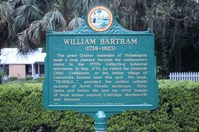
On NE Cholokka Blvd (County Road 234), on the left.
The great Quaker naturalist of Philadelphia made a long journey through the southeastern states in the 1770's collecting botanical specimens. In May, 1774, he visited the Seminole Chief, Cowkeeper, at the Indian village of Cuscowilla located near . . . — — Map (db m146839) HM
On Riverside Lane at Canyon Drive (Alabama Route 35), on the left when traveling west on Riverside Lane.
The river originates in Lafayette in Walker County, Georgia, flows through Chattooga County, Georgia and then enters Cherokee County before emptying into Weiss Lake. Prior to the construction of the lake, the Chattooga River converged with the Coosa . . . — — Map (db m137513) HM
On Veterans Memorial Boulevard (Georgia Route 9) south of Main Street ( Route 20), on the right when traveling south.
Forsyth County was created by Act of Dec. 3, 1832 from Cherokee County. It was named for Gov. John Forsyth (1780-1841), a native of Frederick Co., Va., a graduate of Princeton, and gifted Georgia lawyer. He was Attorney-General of Ga., Congressman, . . . — — Map (db m33575) HM
On North Thornton Avenue (U.S. 41) just north of West Crawford Street, on the right when traveling north.
George Whitefield (1714-70) was a noted evangelist, born in Gloucester, England. He met John and Charles Wesley at Oxford and with them formed the Holy Club. Ordained deacon in 1736, he followed the Wesleys to Georgia in 1738 and founded Bethesda . . . — — Map (db m44787) HM
On South Main Street (State Highway 124) at East Broad Street, on the left on South Main Street. Reported permanently removed.
As a tribute to his skills exploiting enemy weaknesses, Pickens became known as the "Wizard Owl" or "Skyagunsta" - a bird known for seeing clearly, acting wisely and striking quickly.
Pickens was a tall, religious Presbyterian from . . . — — Map (db m259654) HM
On County Route 33 at County Route 29, on the left when traveling south on County Route 33.
In 1835, pioneering families migrated from Morgan County, Georgia to Cherokee County, AL, settling in the Ambersonville area, later renamed Spring Garden. These families were members of Carmel Presbyterian Church in Morgan County and brought their . . . — — Map (db m132792) HM
On North Street 0.1 miles west of North Church Street, on the right when traveling west.
Cherokee County, located along Georgia’s gold belt, figured prominently in the gold rush of the 1830’s and 40’s. Several mines operated along a five mile area near the Etowah River in the northeastern part of the county, including the . . . — — Map (db m225896) HM
On Arnold Mill Road (Georgia Route 140) 0.2 miles north of Chadwick Farm Boulevard, on the right when traveling north.
Circa late 1830s, homestead of Brigadier General and State Senator Eli McConnell and his wife Savilla Garrison. This house was one of the first in the original Cherokee County, established in December 1832. Governor Troup authorized McConnell to . . . — — Map (db m118146) HM
Near Mill Street 0.3 miles east of Atlanta Street, on the right when traveling south.
Roswell King’s primary objective from the very beginning was to establish a textile industry in the area.
In 1835, Roswell King purchased Land Lot #416 in the 1st District, 2nd Section, the location of the first cotton mill. Site preparations . . . — — Map (db m227978) HM
Near Peachtree Street at Alpine Street, on the right when traveling north.
Cherokee Heritage Trails (Tsalagi Usdi Nvnohi) wind through the mountains of North Carolina, Tennessee, and Georgia, in the heart of Cherokee homelands that once encompassed more than 140,000 square miles. Here, where Cherokee people have lived . . . — — Map (db m134947) HM
On Cherohala Skyway (Bypass Route 165) at Herford Street, on the left when traveling west on Cherohala Skyway.
Cherokee Heritage Trails (Tsalagi Usdi Nvnohi) wind through the mountains of North Carolina, Tennessee, and Georgia, in the heart of Cherokee homelands that once encompassed more than 140,000 square miles. Here, where Cherokee people have lived . . . — — Map (db m75410) HM
Cherokee Heritage Trails (Tsalagi Usdi Nvnohi) wind through the mountains of North Carolina, Tennessee, and Georgia, in the heart of Cherokee homelands that once encompassed more than 140,000 square miles. Here, where Cherokee people have lived for . . . — — Map (db m75440) HM
Cherokee Heritage Trails (Tsalagi Usdi Nvnohi) wind through the mountains of North Carolina, Tennessee, and Georgia, in the heart of Cherokee homelands that once encompassed more than 140,000 square miles. Here, where Cherokee people have lived for . . . — — Map (db m281288) HM
In Memory of
William Anderson
Who was born in
County Antrim, Ireland
Oct. 1, 1821
Emigrated to America, 1841
Died far from home, among
kind-hearted strangers
May 1, 1847 . . . — — Map (db m44272) HM
On County Road 2908 0.1 miles south of State Highway 294.
In 1855, brothers Thomas Jefferson “Jeff” (1832-1915) and Jasper (1830-1891) Landrum and others left Fayette County, Georgia, and settled in Cherokee County, Texas, five miles west of Alto. They obtained 640 acres and grew a self-sufficient farm . . . — — Map (db m289576) HM
On Van Bibber Road 0.1 miles east of North Main Street, on the left when traveling east.
Rev. Denman was born in Gumlock Creek, Franklin Co., Georgia on May 8, 1803 and moved to Cherokee County, Texas with his first wife, Elizabeth Randle (1805-1861), in 1849. There he established a large plantation and ran a general store with the help . . . — — Map (db m203301) HM
Near Locust Street at County Highway 1419, on the left when traveling north.
(preface)
In 1838, the United States government deported more than 16,000 Cherokee Indian people from their homelands in Tennessee, Alabama, North Carolina, and Georgia, and sent them to Indian Territory (now Oklahoma). Thousands of . . . — — Map (db m156080) HM
Near Locust Street at County Highway 1419, on the left when traveling north.
(preface)
In 1838, the United States government deported more than 16,000 Cherokee Indian people from their homelands in Tennessee, Alabama, North Carolina, and Georgia, and sent them to Indian Territory (now Oklahoma). Thousands of . . . — — Map (db m156081) HM
Near Elm Road 0.3 miles east of Belton Drive, on the right when traveling east.
Established about 1785, Cleveland County's oldest and most historic church cemetery contains remains of the earliest settlers from nearby communities and their descendants. Among those buried here are heroes of the Revolutionary War, the Indian . . . — — Map (db m285815) HM
This passenger and freight depot was built in 1896 by the Southern Railway and was originally 1 block N. at Brown & Church Sts. It replaced an 1873 depot on the Atlanta & Charlotte Air Line Railway, later merged into the Southern. This depot . . . — — Map (db m83321) HM
On Main Street (U.S. 231) 0.1 miles east of Bailey Street, on the right when traveling south.
In late April 1863, Union colonel Abel D. Streight set out on a raid
from Eastpoint. Mississippi, to Rome, Georgia, charged with disrupting
crucial Confederate supply lines. Streight crossed into north Alabama
with 1,700 men. including members . . . — — Map (db m295685) HM
Francis L. Sampson
1912-1996
Francis L. Sampson's amazing record as a war hero put him in history books. As the "Paratrooper Padre" in World War II, he was one of the 20th century's best-known Army Chaplains. His real life story of . . . — — Map (db m126926) HM WM
Thin black lines indicate changes in relevance. Between each pair of lines entries are ordered geographically but all have the same relevance.
* Inflectional forms of words are their plurals, singulars, and possessives as well as gramatical tenses and similar variations.