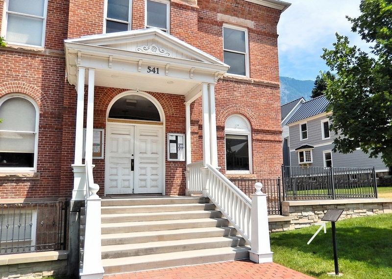
On 4th Street just south of 6th Avenue, on the left when traveling south.
Interior courthouse scenes from the movie True Grit were shot here. Dissatisfied with the sheriff's efforts to track down her father's killer, Mattie takes matters into her own hands. Following Cogburn's testimony, she runs after him down the . . . — — Map (db m282786) HM
On Main Street (U.S. 550) just north of 6th Avenue, on the left when traveling north.
Restaurant owner Addie Bonatti was mortified to discover it was John Wayne calling after telling him she was too busy serving customers to put a crew member on the phone. Later when he met this saucy woman, Wayne gave her his hat, and returned . . . — — Map (db m282657) HM
On Main Street (U.S. 550) just north of 4th Avenue, on the right when traveling north.
Imagine being an early pioneer here and building a cabin on the main trail through town. You are fascinated by the passing bands of Ute Indians, and admire the cascading falls, and magnificent amphitheatre high above you to the east. Uncompahgre . . . — — Map (db m294690) HM
On Main Street (U.S. 550) just south of 7th Avenue, on the right when traveling south.
Picture yourself walking along the east side of Main Street between 6th and 7th Avenues during Ouray’s early times. You will meet some of Ouray's important businessmen. These men — Otto Mears, David Day, and Dr. William Rowan — were also colorful . . . — — Map (db m294939) HM
On Main Street (U.S. 550) just south of 6th Avenue, on the right when traveling south.
Illustrated here are two early periods of structural development across Main Street from this location. There were only four buildings occupying four of the twelve lots on the block, circa 1880-1883. The one-story building at 515 Main is thought to . . . — — Map (db m294812) HM
On Main Street (U.S. 550) just north of 8th Avenue, on the right when traveling north.
Looking across Main Street at part of the notorious “red light district,” called the Vanoli Block, try to visualize how it looked and hear how it sounded in the late 1890s and early 1900s. On the alley at the back of lots 23 and 24 was freighter . . . — — Map (db m294983) HM
On Main Street (U.S. 550) just north of 7th Avenue, on the right when traveling north.
Substantial brick buildings replaced wooden structures on this block by the 1890s. Louis King's two-story wagon and carriage shop dominated the south end when a wooden structure in the 1880s and as a brick beauty in the '90s. James Pierson's . . . — — Map (db m294976) HM
On Main Street (U.S. 550) just north of 5th Avenue, on the right when traveling north.
Standing here, one sees significant change across the street between the mid-1880's, 1902, and the present. In 1876 two wooden buildings were erected at the north end of this block. The next year a two-story frame building, known as the Bucket of . . . — — Map (db m294698) HM
On West Colorado Avenue at Oak Street (now a pedestrian walkway), on the right when traveling east on West Colorado Avenue.
Prior to Spanish exploration in the Telluride region, Native Americans of the Ute tribe used this area as a seasonal hunting ground. In the 1870's, however, mining ventures and a substantial population growth displaced the Utes further Southwest . . . — — Map (db m282984) HM
On North Railroad Street just north of Sherman Street (State Highway 62), on the right when traveling north.
Filmed in and around Ridgway, CO September 1968. Released 1969. This paddy wagon was built specifically for the True Grit movie by Joe English, Owen Vaughn, and Paul Gibbs. An extensive photo collection of the pre-test shots taken by Paramount of . . . — — Map (db m282801) HM
Near North Railroad Street just north of Sherman Street (State Highway 62), on the left when traveling north.
Mattie arrives at the Fort Smith train station to claim her father's body. The movie's depot was a freight storage structure modified from the original Rio Grande Southern depot, which had been moved south 100 yards. The train was a Rio Grande . . . — — Map (db m282795) HM
Near North Railroad Street just north of Sherman Street (State Highway 62), on the left when traveling north.
After finding the mortuary closed with the undertaker gone to the triple hanging, Mattie joins the enthusiastic crowd to watch. The gallows was erected just west of this sign. Although he was not listed in the credits, Jay Silverheels, who played . . . — — Map (db m282796) HM
On Clinton Street at North Lena Street, on the left when traveling east on Clinton Street.
Colonel Stonehill's livery stable and corral were constructed by local carpenters where the post office now stands. Here Mattie Ross haggles with Colonel Stonehill over the value of her father's horses and threatens to call in Lawyer Daggett. The . . . — — Map (db m282797) HM
On Clinton Street just west of North Lena Street, on the right when traveling west.
This was the mortuary, labeled R. Ryan Embalmer on the window, where Mattie identified her father's body. The stone building west of the Sherbino at 620 Clinton St. was Chen Lee's general store/living quarters, where Cogburn boarded. There Mattie . . . — — Map (db m282798) HM
On North Lena Street just north of Sherman Street (State Highway 62), on the left when traveling north.
The impressive Fort Smith courthouse was a building front and entryway created for the movie. It was located where this building now stands. Interior scenes were filmed 10 miles south of Ridgway at the Ouray County Courthouse. John Wayne won his . . . — — Map (db m282799) HM
On North Lena Street just north of Sherman Street (State Highway 62), on the left when traveling north.
The True Grit Cafe was built in 1986 as a tribute to John Wayne and True Grit. Incorporated in the cafe's construction, the grocery store facade from next door is now the cafe south wall. Also featured are photos of Ridgway resident and . . . — — Map (db m282800) HM
On Million Dollar Highway (U.S. 550) 2 miles south of County Highway 31, on the left when traveling north.
The Idarado Mining Company was founded in 1939 in a consolidation of mining claims including the Black Bear, Treasury Tunnel, Barstow, and the Imogene mines. In June 1943, work began to extend the Treasury Tunnel below the Black Bear Mine to . . . — — Map (db m179028) HM
On East 18th Avenue at Logan Street, on the right when traveling west on East 18th Avenue.
This site was once the home of the Cathedral Grade School. The building was designed by renowned Denver architect Frank Edbrooke in the Classic Romanesque style. It was built in 1891, suffered a devastating fire in 1955, and was completely . . . — — Map (db m289560) HM
On Million Dollar Highway (U.S. 550) 0.1 miles south of County Highway 16, on the left when traveling north.
Nineteenth-Century Newspapers
At one point in the 1880s, Ouray newspaper publisher David Day had forty-two libel suits pending against him-and he wore them like a row of combat medals. Day's broadsheet, the Solid Muldoon, placed less emphasis . . . — — Map (db m186909) HM
On Million Dollar Highway (U.S. 550) 0.2 miles west of County Highway 20, on the left when traveling east.
W.C. Davis and G.C. McGee recorded the Ida L. and Dauntless mining claims in 1888. In 1893 Davis sold his interest in these and other claims to W.F. Abrams of San Diego, California. McGee kept his interest until selling it to A.G. Bruner in 1910. . . . — — Map (db m238162) HM
Near North Railroad Street just north of Sherman Street (State Highway 62), on the right when traveling north.
This caboose was built in Denver at the Burnham shops in 1886. It is a 17-foot caboose often called a 'crummy'. When new it was DRG 91 as seen on the west side. When it was taken out of service in 1953 it looked like it does on the east side as the . . . — — Map (db m295882) HM
On Main Street (U.S. 550) at 10th Avenue, on the right when traveling south on Main Street.
The Fellin family has left a huge landmark in Ouray County In approximately 1895 Joseph Fellin, a miner from Revo, Austria, came to Ouray, Colorado. In 1902, Joseph's wife Serafina and his sons Sam, Oliver, and Angelo arrived. Five years later . . . — — Map (db m294697) HM
On Million Dollar Highway (U.S. 550) 2 miles south of County Highway 30, on the right when traveling north.
Panel 1 This region was founded by gold and silver miners in the 1870s. This 17-square mile area has produced 4 million ounces of gold, 21 million ounces of silver, and 12 million tons of lead, zinc and copper. The natural resources from . . . — — Map (db m179088) HM
On 6th Avenue just east of Main Street, on the left when traveling east.
Presented to the City of Ouray in 1900 A.D. by Thos. F. Walsh, original owner of the Camp Bird Mine. The bell hung in the City Hall bell tower until 1950, when it was cracked by fire. — — Map (db m294499) HM
Thin black lines indicate changes in relevance. Between each pair of lines entries are ordered geographically but all have the same relevance.
* Inflectional forms of words are their plurals, singulars, and possessives as well as gramatical tenses and similar variations.