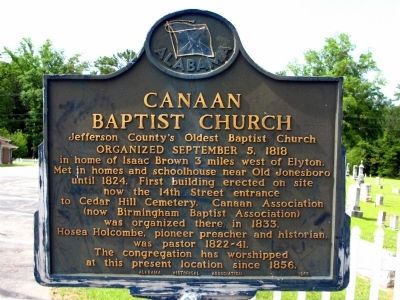
Organized September 5, 1818 in home of Isaac Brown 3 miles west of Elyton. Met in homes and schoolhouse near Old Jonesboro until 1824. First building erected on site now the 14th Street entrance to Cedar Hill cemetery. Canaan Association (now . . . — — Map (db m37218) HM
On Arlington Avenue at 19th Street South, on the right when traveling west on Arlington Avenue.
This house was built in 1906 by architect William E. Benns for H. W. Sweet at a cost of $10,000. The house uniquely blended the Queen Anne and Neo-Classical architectural styles, featuring two identical pedimented entrance porticos supported by . . . — — Map (db m27024) HM
Near Alpha Street South at Kappa Avenue South, on the right when traveling north.
Memorial Park is the site of the Miracle Sunday Prayer Vigil that occurred on May 5, 1963. to protest the incarceration of Civil Rights demonstrators held in the city jail. Citizens attending a mass meeting at New Pilgrim Baptist Church staged a . . . — — Map (db m295304) HM
On 1st Street South south of 1st Avenue South, on the right when traveling south.
Former members of Broad Street Baptist of Elyton organized South Elyton Baptist Church in November 1914, and named it for its location south of the AGS railroad, distinguishing the community from Old Elyton Architect and neighbor Wallace Rayfield . . . — — Map (db m295301) HM
On 1st Street South at 4th Avenue South, on the right when traveling north on 1st Street South.
In 1909, the township of Elyton built a school for African American children in Titusville on this site. Pioneer Black architect Wallace Rayfield, who lived nearby. selected the site. designed the building. and recommended the building contractor . . . — — Map (db m295298) HM
On 6th Avenue South at 2nd Street South, on the right when traveling south on 6th Avenue South.
Civil Rights Evangelism for Justice
Rev. Joseph W. Ellwanger, the dynamic pastor of St. Paul Lutheran Church from 1958 to 1967, was a member of the Central Committee of Strategists for the Birmingham Civil Rights Campaign of 1963. On March . . . — — Map (db m295302) HM
On Woodward Street at Huntsville Avenue on Woodward Street.
Lynching In America.
Thousands of black people were the victims of lynching and racial violence in the United States between 1877 and 1950. The lynching of African Americans during this era was a form of racial terrorism intended to intimidate . . . — — Map (db m101159) HM
On Main Street east of Center Point Road (State Highway 75), on the left when traveling east.
Pinson, one of Alabama’s oldest communities, was settled by General Andrew Jackson’s soldiers in the early 1800s, after victory at Horseshoe Bend during the War of 1812. The community was originally known as Hagood’s Crossroads for settler . . . — — Map (db m88406) HM
On 7th Avenue North west of 24th Street North, on the right when traveling west.
National Register of Historic Places
In many ways, the 1954 Brown v. Board of Education decision fueled the modern Civil Rights Movement. The NAACP's legal team strategically chipped away at the “separate but equal" doctrine to end . . . — — Map (db m188205) HM
On 5th Avenue North, on the right when traveling east.
During the first 30 years of his 54-year-old practice, Attorney Shores practiced all over the State of Alabama - from the Tennessee line to the Gulf of Mexico at Mobile Bay, and from the Mississippi borders to the Georgia limits. During the period . . . — — Map (db m26720) HM
On South Shades Crest Road 0.8 miles south of Bessemer Cut Off Road (State Highway 150), on the right when traveling south.
In 1858, the State of Alabama, wanting to develop coal and iron industries in Jefferson County, Had John T. Milner survey Shades Mountain for the most practical route for the South and North Railroad to cross. He selected Brock's Gap, named for . . . — — Map (db m26773) HM
Disabled American Veterans Formed December 25, 1920.
Birmingham Chapter No. 4 Chartered January 25, 1926.
This memorial dedicated to our military forces and to all who have given their blood and lives that the republic might . . . — — Map (db m24347) WM
On Highland Avenue, on the right when traveling west.
Dr. Mortimer Harvie Jordan and his wife, Florence E. Mudd, constructed their home between 1906 and 1908. After service in the Confederate army, Jordan studied medicine in Cincinnati and New York (under Alabama's famous gynecologist, Dr. J. Marion . . . — — Map (db m26743) HM
On Tuscaloosa Avenue SW at 3rd Street SW, on the left when traveling east on Tuscaloosa Avenue SW.
In 1818 before Alabama, Jefferson County, Elyton or Birmingham existed, The Elyton Methodist Church was established on Center Street. It was moved to 14 Second Avenue, and in 1909, to its present site. Renamed in 1910 for Corilla Porter Walker . . . — — Map (db m24348) HM
Samuel Massey and his brother - in - law, Duke William Glenn, first came to this Territory in February 1814 with Lt. Col Reuben Nash's Regt. South Carolina Volunteer Militia to help defeat the Creek Indians in the War of 1812. Samuel Massey returned . . . — — Map (db m25088) HM
On Allison-Bonnett Memorial Drive at Tin Mill Road, on the right when traveling west on Allison-Bonnett Memorial Drive.
Bethlehem United Methodist Church is one of the oldest churches in Jefferson County, dating back to 1818 and the efforts of Rev. Ebenezer Hearn. In April 1818, the Tennessee Conference of Methodist Churches sent Rev. Hearn south of the Tennessee . . . — — Map (db m212543) HM
On Parkway Drive (U.S. 78) at 6th Steet Southeast, on the right when traveling east on Parkway Drive.
The War of 1812, geography, geology, and three cultures shaped the history of Leeds. Lying at the crossroads of ancient Indian paths in the center of Alabama, Leeds drew Europeans, Cherokee, and African-American settlers to a land of fertile . . . — — Map (db m49351) HM
On North 1st Street at Locust Street, on the right when traveling north on North 1st Street.
Lynching in America.
Thousands of Black people were the victims of lynching and racial violence in the United States between 1877 and 1950. The lynching of African Americans during this era was a form of racial terrorism intended to intimidate . . . — — Map (db m116817) HM
On Hueytown Road at High School Road, in the median on Hueytown Road.
During the early 1800s, members of the Huey family took pioneering steps toward establishing the community that would eventually become the City of Hueytown. On May 6, 1960. Hueytown
was officially incorporated under a Mayor/Council form of . . . — — Map (db m212934) HM
On Eastern Valley Road (State Road 119), on the right when traveling east.
Front:
In 1915, the men of the Mt. Hebron Community cleared the land donated by Bess Simmons for a school. Trees donated by Mitch Poole were placed on Rufus Brasher’s wagon and taken to Will Scott’s sawmill. The school opened in the fall . . . — — Map (db m83918) HM
Near 3rd Street Southwest south of Cotton Avenue Southwest, on the right when traveling south.
From 1820 until 1878 this bell hung in the
belfry of the old Elyton courthouse, one-half mile northeast of this spot. In 1861
Jefferson County boys were mustered in
there and the bell tolled them off to war.
John Felix McLaughlin was one of . . . — — Map (db m216063) HM
On 29th Avenue North west of 33rd Street North, on the left when traveling west.
Alabama's chapters of the National Association for the Advancement
of Colored People (NAACP) were particularly effective in filing federal
lawsuits that challenged racial segregation laws and advocating for
voting rights. NAACP members also . . . — — Map (db m188970) HM
On Richard Arrington Junior Boulevard South north of 1st Ave South, on the left when traveling north.
On May 10, 1919, soon after its completion, this 21st Street Viaduct was named the Rainbow Viaduct in tribute to Alabama's famous 167th Infantry of the Rainbow Division, renowned for Bravery and Honor. The 167th was the Nation's only regiment in . . . — — Map (db m83860) HM
On Springville Road (County Road 30) north of Deerfoot Parkway, on the right when traveling north.
The clay soil of the area, first cultivated by Creek Indians, gave this agricultural community it name in 1878 when a post office was established. Clay’s historical roots date to the early 1800s through two small communities, Ayres and Self’s Beat, . . . — — Map (db m83863) HM
On Fairway Drive east of Cahaba Road, on the right when traveling east.
1,000 feet East a small group of tents erected May, 1910 by the
Anti Tuberculosis Association of Jefferson County
constituted the first effort to aid victims of tuberculosis in North Alabama. — — Map (db m26964) HM
On 6th Avenue North west of 17th Street North, on the left when traveling west. Reported damaged.
Civil rights activist and pastor, the Rev. Calvin Wallace Woods Sr. was born in Birmingham in 1933. The son of a Baptist preacher, Woods attended historic miles college and various seminary institutions. He distinguished himself as a leader during . . . — — Map (db m187533) HM
Racial Terrorism and Convict Leasing. Thousands of black people were the victims of lynching and racial violence in the United States between 1877 and 1950 Lynching was
a form of racial terrorism that went beyond only hanging, . . . — — Map (db m173372) HM
The Depot was built by Richmond & Danville Extension Co. in 1883-84 following the completion of the Georgia & Pacific RR line between Birmingham and Atlanta, three years before the Town of Leeds was incorporated.
Richmond Terminal Co. operated . . . — — Map (db m22209) HM
On Stone River Road north of Old Leeds Lane, on the left when traveling north.
Wallace S. McElwain (1832-1888)McElwain trained in a gun factory in New York and in a foundry in Ohio before moving to Holly Springs, MS, where he operated Jones, McElwain and Company Iron Foundry. He was well known in the Southeast for his . . . — — Map (db m26266) HM
On Alabama Avenue north of 19th Street N, on the right when traveling north.
The Bessemer Site was the largest
indigenous mound site in what is now
Jefferson County, and it once dominated
a large territory in what became
north-central Alabama. Occupied from
about AD 1150 to 1250 during the early
Mississippian period, . . . — — Map (db m144908) HM
Territorial legislature designated home of Maj. Moses Kelly (in Jones Valley) as site of first court in this area of Alabama, 1818.
After creation of Jefferson County, 1819, court held at Carrollsville (Powderly) until county seat established . . . — — Map (db m25743) HM
On South Main Street south of 2nd Avenue SE, on the right when traveling south.
(side A)
In the latter 1800s and early 1900s, the city of Graysville was called Gin Town. Because Graysville had the only cotton gin for miles around, the town and community grew. As the community grew, the need for businesses and houses of . . . — — Map (db m43221) HM
On North 1st Street north of 19th Street North, on the right when traveling north.
Racial Terrorism and Criminal Justice. Racial terror lynching between 1865 and 1950 claimed the lives of thousands of African Americans and created a legacy of injustice that can still be felt today. After emancipation, white Southerners . . . — — Map (db m167223) HM
On Main Street at Bell Street, on the right when traveling north on Main Street.
Side A When Andrew Jackson defeated the Creek Nation at the Battle of Horseshoe Bend in 1814, the subsequent Treaty of Fort Jackson and other treaties that followed ceded Indian land that made up most
of what is now Alabama. Abraham Stout . . . — — Map (db m39111) HM
David King Wall, one of Golden’s early permanent settlers, arrived from South Bend, Indiana on April 30, 1859. He brought a great deal of garden seed and tools with him. King defied the common belief that growing a garden would be impossible due to . . . — — Map (db m50595) HM
On Center Street south of 10th Court West, on the right when traveling south.
1953
During the early 1950s, moderate White business
leaders pressured city officials to find and prosecute
the Dynamite Hill bombers and explore racial
reforms. In April 1951, some worked with moderate
Blacks to form the Interracial . . . — — Map (db m189176) HM
Near Valley View Drive west of Richard Arrington Jr Boulevard South.
Red Mountain, where you are standing, and Jones Valley, which stretches before you, were sites of human activity long before Birmingham's founding in 1871.
Native American presence
Recorded history and archaeological evidence indicate the . . . — — Map (db m83805) HM
On West Jefferson Road at Freewill Drive, on the left when traveling west on West Jefferson Road.
In the late 19th century, mines began opening in West Jefferson County,
spurred by the expanding steel and iron industry in the Birmingham
district. As more mines opened, more families settled in the area during
the 1920s, creating a need to . . . — — Map (db m296446) HM
Near Old Moultrie Road (County Route 5A) at Cemetery Road, on the right when traveling north.
Erected in memory of the Minorcans from St. Augustine who served honorably during the War Between the States
Dedicated to the ten Confederate Soldiers buried in unmarked graves in San Lorenzo Cemetery
Andreu, Claudio D. PVT Company B, 1st . . . — — Map (db m256203) HM WM
Near West Elk Avenue (U.S. 321) west of Franklin Springs Circle, on the right when traveling west.
"Be always sure you are right, then go
ahead!" David Crockett
In the 49 years that David Crockett called Tennessee his home he migrated from one end of the Volunteer state to the other. From his birthplace near Limestone on the . . . — — Map (db m268085) HM
In the 49 years that David Crockett called Tennessee his home he migrated from one end of the Volunteer state to the other. From his birthplace near Limestone on the banks of the Nolichucky River to his last home in present day Rutherford (Gibson . . . — — Map (db m107422) HM
Thin black lines indicate changes in relevance. Between each pair of lines entries are ordered geographically but all have the same relevance.
* Inflectional forms of words are their plurals, singulars, and possessives as well as gramatical tenses and similar variations.