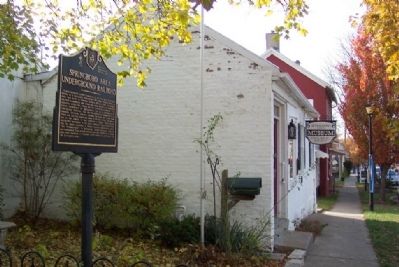
On Main Street (Ohio Route 741) at North Street, on the right when traveling north on Main Street.
A predominantly Quaker community in its early days, Springboro served as a hospitable thoroughfare for many runaway slaves on their way north to freedom. Between 1815 and 1864, Springboro was host to numerous safe-houses and many agents and . . . — — Map (db m227946) HM
On North Street at East Street, on the left when traveling east on North Street.
The United Brethern [sic] Church building and bell tower were built in 1874. By 2004 the original wooden bell house had been modified to remove the gothic gables. In 2007, a [sic] appropriate, but not original gothic steeple was built on the . . . — — Map (db m13700) HM
On South Main Street, on the right when traveling north.
This monument recognizes the 200 year bicentennial celebration, honoring Springboro founder, Jonathan Wright (1782-1855). His vision for equality and diversity were guiding principles as a conductor on the Underground Railroad. Jonathan's legacy was . . . — — Map (db m228625) HM
On Main Street (Ohio Route 741) at Mill Street, on the right when traveling north on Main Street.
Built in 1919, this building was the first gasoline station in Springboro and served as the bus maintenance facility for Springboro Community City Schools from 1945 to 2001. This shop replaced the home of Mahlon Wright, a son of the village founder . . . — — Map (db m13696) HM
On South Main Street (Ohio Route 741) south of East Market Street, on the right when traveling north.
Elizabeth Cowman, the youngest sister of village founder Jonathan Wright, was living in Baltimore in 1830 when her husband died suddenly, leaving her to care for her two young children. Jonathan Wright sold her the lot on your right (210 South Main) . . . — — Map (db m228621) HM
On South Main Street (Route 741) at East Market Street, on the right when traveling north on South Main Street.
Jonah Thomas purchased the lot on your left (200 South Main) from village founder Jonathan Wright in 1833 for $30 and built the front portion of the building as his home and a harness shop. As a member of the Society of Friends (Quakers), Thomas was . . . — — Map (db m228588) HM
On South Main Street (Ohio Route 741) south of West Lower Springboro Road, on the right when traveling north.
This house appears to have been built circa 1832, possibly by Joseph Penrose, and served as a "station" on the Underground Railroad, a place that offered assistance to runaway slaves during their flight to freedom. According to local legend, a . . . — — Map (db m228629) HM
On South Main Street (Ohio Route 725) at West Lower Springboro Road, on the right when traveling north on South Main Street.
This house was a "station" on the Underground Railroad, a place that offered assistance to runaway slaves during their flight to freedom. Early building owners include James Janney who bought the house in 1835, James Farr who bought the house in . . . — — Map (db m228628) HM
On Main Street (Ohio Route 741) at North Street, on the right when traveling north on Main Street.
Built by Clark Williams, this early brick Federal style building was owned by the Dayton Leather & Collar Company in the late 1800s. In the early 1900s it was owned by Napoleon Johnson, a former slave who was freed in Virginia in 1847 when his . . . — — Map (db m13717) HM
On Main Street (Ohio Route 741) at Factory Road, on the right when traveling north on Main Street.
This house was built as the home of Jeremiah and Nancy (Gregg) Stansel. Jeremiah's father, Henry Stansel, was a friend of Daniel Boone. Although not a member of the Society of Friends (Quakers), Jeremiah is thought to have assisted runaway slaves, . . . — — Map (db m13712) HM
On Main Street (Ohio Route 741) at Market Street, on the right when traveling south on Main Street.
Jonah Thomas bought this building in 1837 when he moved his home and harness shop from across the street at 200 South Main. As a “conductor” on the Underground Railroad, Thomas opened his home as a “station” on the . . . — — Map (db m13714) HM
On Main Street, on the right when traveling north.
The fraternal order of the Knights of Pythias was founded in Washington, D.C. in 1864 as an organization dedicated to healing the wounds and hatred of the Civil War. The members of the local Springboro Lodge No. 574 built this meeting hall with a . . . — — Map (db m227945) HM
On Main Street (Ohio Route 741), on the right when traveling south.
Harry Pence grew up on a family farm nearby and later became a successful businessman who lived in Minneapolis. He had this Queen Anne style house built for his parents, Charles and Ruth Pence. Harry's brother Warren along with his wife Clara and . . . — — Map (db m13703) HM
On Main Street (Ohio Route 741) at South Street, on the right when traveling north on Main Street.
John Bateman was a local tanner who had his house, storehouse, and workshop on this site. The house now located at 440 South Main was built circa 1869 by Joseph Haines, a carpenter who built a number of Springboro homes in the mid and late 1800s. . . . — — Map (db m227952) HM
On Central Avenue (Ohio Route 73) at Main Street ( Route 741), on the right when traveling east on Central Avenue.
This pin oak tree has been placed here in living memory of Lynn O. Eaton, a charter member of the Springboro Lions Club. Lion Eaton was ever ready to assist his fellow man in all and every manner needed. He served in many civic offices and was . . . — — Map (db m13698) HM
On Main Street (Ohio Route 741) at South Street, on the right when traveling south on Main Street.
Tommy Miller had this house built on the foundation of an earlier home that had served for a time as a parsonage for the Methodist church. Possible traces of an Underground Railroad hiding place from that earlier era are still evident in the . . . — — Map (db m13701) HM
On Main Street (Ohio Route 741) at State Street, on the right when traveling south on Main Street.
This site was purchased by Josiah Townsend in 1827 for $50. In 1830, the property was sold for $1,500, suggesting that a house was built on the property sometime before 1830. Emmor Bailey, a member of the Society of Friends (Quakers), bought the . . . — — Map (db m13694) HM
On Main Street (Ohio Route 741), on the right when traveling south.
This building was built as a general store for Mahlon and Josiah Wright, sons of the village founder, Jonathan Wright. The building originally had a shed roof extending out over the street to protect customers from the weather. A large stepping . . . — — Map (db m13718) HM
On Main Street (Ohio Route 741), on the right when traveling south.
Springboro's town hall and town jail occupied this site for nearly 100 years. This was also the site of the town's first fire station. According to local history, this building was built circa 1922 by volunteers with donated materials after an . . . — — Map (db m13715) HM
On Main Street (Ohio Route 741) at Factory Road, on the right when traveling north on Main Street.
Warner Bateman, nephew of the village founder Jonathan Wright, was an “agent” on the Underground Railroad. An “agent” was one who provided assistance to runaway slaves on their way to freedom. As an attorney, Bateman was in . . . — — Map (db m13692) HM
On Main Street (Ohio Route 741), on the right when traveling north.
This oldest building in the historic district was the home of Griffy Griffis five years before the village was founded by Jonathan Wright in 1815. Since Griffis had no legal right to the property, it became known as the “Squatter's . . . — — Map (db m13711) HM
On Main Street (Ohio Route 741), on the right when traveling south.
The house on the right (45 South Main) appears to have been built circa 1832 by Joshua Trotter. In 1837, Trotter sold the house to John and Mary Potts, who were “conductors” on the Underground Railroad, persons who risked their lives and . . . — — Map (db m13704) HM
On Main Street (Ohio Route 741) at State Street, on the right when traveling north on Main Street.
This house was built by Joseph Stanton, son-in-law of local abolitionist James Stanton. Lydia Wood owned the house from 1875 until her death at age 86 in 1917. Lydia was the aunt of artist Grant Wood who pained the famous “American . . . — — Map (db m13713) HM
On State Street 0.1 miles west of Main Street, on the right when traveling west.
Jonathan Wright (1782-1855) and his wife Mary Bateman Wright (1787-1866) moved with their five children from Menallen, Adams County, Pennsylvania, in 1814 and built this Federal style house. Using skills acquired from his father, Joel Wright, a . . . — — Map (db m26547) HM
On Main Street (Ohio Route 741) at Factory Road, on the right when traveling south on Main Street.
The Independent Order of Odd Fellows (IOOF) began in England in the 1700s as an association of common laborers who met together for fellowship and mutual aid. This was so unusual at the time that members were called “Odd Fellows,” and . . . — — Map (db m13702) HM
On Heatherwoode Circle, on the right when traveling north.
The oldest on-site exposed log structure in Warren
County, it was built by Christian and Charles Null.
Renovated in 1995-96 by the city of Springboro,
the Springboro Area Historical Society,
the Historical Commission, and over 70 volunteers. — — Map (db m84403) HM
On Ohio Route 48 at Lower Springboro Road (County Road 22), on the right when traveling south on Ohio Route 48.
Having settled in the Ridgeville area with his father, Justice McLean, in 1799, Justice John McLean was appointed to the United States Supreme Court in 1829 by President Andrew Jackson. He was best known for his anti-slavery dissenting opinion in . . . — — Map (db m26546) HM
On South Main Street, on the right when traveling north.
Named after Springboro's founder, the Jonathan Wright Chapter of the National Society Daughters of the American Revolution was organized in December 2000. — — Map (db m228627) HM
Members of the religious Society of Friends were
instrumental in the founding and development of
Springboro.
This plot contains the remains of Springboro founder
Jonathan Wright (1782- 1855), a Quaker leader who donated
part of his land . . . — — Map (db m84495) HM
On West National Road (U.S. 40) west of Patty's Road, on the right when traveling west.
You Are At East Park 4361 W. National Rd., Vandalia
Latitude: 39.875653 Longitude: -84.277499
Welcome To Englewood Metropark
Englewood Metro Park became one of Five Rivers MetroPark's facilities in 1967. Englewood Dam is part of . . . — — Map (db m260970) HM
On South Cassel Road at East National Road (U.S. 40), on the right when traveling north on South Cassel Road.
You Are At North Park 2005 U.S. 40, Vandalia
Latitude: 39.877099 Longitude: -84.169101
Welcome To Taylorsville Metropark
Taylorsville MetroPark opened to the public on April 1, 1967. One of the first of Five Rivers MetroParks . . . — — Map (db m261054) HM
Thin black lines indicate changes in relevance. Between each pair of lines entries are ordered geographically but all have the same relevance.
* Inflectional forms of words are their plurals, singulars, and possessives as well as gramatical tenses and similar variations.