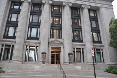
The Church of Jesus Christ of Latter-day Saints constructed this building between 1914 and 1917 to serve as its headquarters. Prior to its completion, the office of the Church President was located just to the east between Brigham Young’s Lion . . . — — Map (db m35685) HM
On South Temple Street at Main Street, on the right when traveling west on South Temple Street.
The Hotel Utah was the “Grande Dame” of hotels in the Intermountain West. For most of the 20th century. the hotel hosted Utah’s most distinguished visitors and was a focal point of local social activity. As one historian wrote, . . . — — Map (db m35747) HM
The Lion House takes its name from the carved lion on top of the front portico. The house was constructed with adobe blocks, a common building material during Utah’s settlement period. Brigham Young, second president of the Church of Jesus Christ of . . . — — Map (db m173258) HM
On 200 East, on the right when traveling south. Reported missing.
The Salt Lake City & County Building is one of Salt Lake City’s most beloved landmarks.
The building is Utah’s finest example of Richardsonian Romanesque architecture. Numerous detailed carvings, including Indian chiefs, Spanish explorers, and . . . — — Map (db m132257) HM
On South State Street (Utah Route 186) just south of East South Temple, on the right when traveling north.
This building has housed the Alta Club for over 100 years. Prominent Utah businessmen founded the exclusive club in 1883. The original members were all non-Mormons and most were involved in the mining industry. The Alta Club's official . . . — — Map (db m146855) HM
On West 200 South, 0.1 miles east of South 200 West, on the right when traveling east.
The Bertolini Block is one of the few physical reminders of the immigrant communities which flourished in Salt Lake City at the turn of the century. Ignazio Bertolini, an Italian-American real estate developer, constructed the building in . . . — — Map (db m146856) HM
On West Broadway (300 South), on the right when traveling west.
The Broadway Hotel is one of the dozen hotels built in downtown Salt Lake City shortly after the completion of the city's two major rail depots. The building is most notable today for the portico on its southeast corner. This portico marks the . . . — — Map (db m35695) HM
On West 200 South just west of John Stockton Drive (South 300 West) (U.S. 89), on the left when traveling west.
The Crane Company constructed this building in 1910 to house the Salt Lake City branch of its internationally-known valve, engine, plumbing fixture, and heating system business. The company opened its Salt Lake branch in 1902, just a few years . . . — — Map (db m146857) HM
On South Main Street north of South 3rd Street, on the right when traveling south.
This building was constructed in 1902 for David Keith. Keith was another of Utah's mining magnates and a close friend of Thomas Kearns. The two men developed one of the world's most lucrative silver mines, the Silver King in Park City. This building . . . — — Map (db m223414) HM
On Main Street at 100 South, on the right when traveling south on Main Street.
Built in 1864, the Eagle Emporium Building is the oldest existing commercial building in downtown Salt Lake City. William Jennings, Utah's first millionaire, constructed the building to house his mercantile business. The Eagle Emporium Building was . . . — — Map (db m35804) HM
On Main Street north of 200 S, on the right when traveling north.
The First National Bank Building features the oldest known cast iron facade in the Intermountain West. It was designed by Richard M. Upjohn, one of America’s most distinguished 19th-century architects. The building originally had a fourth story . . . — — Map (db m35541) HM
On West Market Street just west of South Main Street, on the left when traveling west.
After Utah became a state in 1896, the Federal Government began planning a building to house federal offices in Salt Lake City. The Treasury Department considered two sites for the building. After vocal opposition from many of Salt Lake City's . . . — — Map (db m146591) HM
On West 200 South just east of 400 West, on the right when traveling east.
The Henderson Block was the first produce warehouse constructed along Salt Lake City’s rail lines. This strategic location helped Wilber S. Henderson transform his produce business into one of the largest wholesale grocery companies in the . . . — — Map (db m146860) HM
On South Main Street south of South 2nd Street, on the right when traveling south.
While 13 stories tall, the Continental Bank Building's main street façade is only three bays wide. The building's narrowness gives it a vertical emphasis. Its design combines Second Renaissance Revival elements on the first two floors and a plain . . . — — Map (db m223395) HM
On Main Street at North 2nd Street, on the right when traveling south on Main Street.
The Karrick Block is the oldest existing work of Richard Kletting, one of Utah's most prominent architects. Kletting is best known for designing the State Capitol Building. The Karrick Block was one of his first commercial works in Utah. Its façade . . . — — Map (db m223413) HM
On Main Street south of South 2nd Street, on the right when traveling south.
The Lollin Block, built in 1894, is the work of prominent Utah architect Richard Kletting. The building reflects Kletting's preference for classical motifs. The building's classical elements include Roman arches, dentil moldings, and egg-and-dart . . . — — Map (db m223411) HM
On East 100 South at South State Street, on the right when traveling west on East 100 South.
The Mountain States Telephone & Telegraph Company finished the first two stories of this building in 1939. The additional four stories were added in 1947 as the demand for telephones boomed after World War II. This building is one of the . . . — — Map (db m146597) HM
On South Main Street just north of University Boulevard (U.S. 89), on the right when traveling north.
Colorful, inlaid tiles and a wide, bracketed cornice adorn the New Grand Hotel. John Daly built the hotel in 1910. Daly owned several lucrative silver mines in Park City, including the Daly-West, and was influential in Salt Lake City’s . . . — — Map (db m146598) HM
On West Market Street west of South Main Street, on the right when traveling west.
When first constructed in 1906, the New York Hotel provided luxurious accommodations for travelers. The building offered steam heat and electric lights in every room while advertisements assured all guests of excellent service. The hotel . . . — — Map (db m146586) HM
On West Market Street west of South Main Street, on the right when traveling west.
The International Order of Odd Fellows wsa one of the many secret fraternal organizations popular in 19th-century America. These organizations engaged in a variety of social and charitable activities. They also offered "fraternal insurance" . . . — — Map (db m146593) HM
On West 200 South east of South 200 West, on the right when traveling east.
This building has housed the same business since its construction in 1914. The Decker-Patrick Company, which advertised itself as "Wholesale dealers in dry goods, notions, and men's and women's furnishing," later changed its name to the Patrick . . . — — Map (db m146858) HM
On West Broadway (West 300 South) west of West Temple Street, on the right when traveling west.
Built just three blocks east of the Denver & Rio Grande Depot, the Peery Hotel was well-placed to take advantage of Salt Lake City's rail traffic. The building has functioned continuously as a hotel since its construction in 1910. The E-shaped . . . — — Map (db m146859) HM
On Pierpont Avenue, on the right when traveling west.
The Oregon Shortline Railroad Company built the lower, eastern section of this building to house its offices in 1897. Shortly therafter, the Salt Lake City School Board contracted with the railroad to build the small annex and larger, more elaborate . . . — — Map (db m35714) HM
On Main Street, on the right when traveling north.
The Salt Lake Herald Building's U-shaped plan is unusual. Many 19th and early 20th- century buildings have a U-shaped plan to allow light and air to reach interior offices. Most often, however, the "U" opens to the rear or the side of the . . . — — Map (db m35543) HM
This street is named Exchange Place after the Salt Lake Stock and Mining
Exchange Building. As part of his efforts to make south downtown the financial center of Salt Lake City, Samuel Newhouse donated this site to the Salt Lake Mining and . . . — — Map (db m35610) HM
On West 200 South west of John Stockton Drive (U.S. 89), on the right when traveling west.
Aaron Keyser constructed this building in 1901 and leased it to Emmanuel Kahn for his grocery business. Kahn was among the first Jewish settlers in Utah. In 1913, the Kahn Grocery Company moved to a new location and the N. O. Nelson . . . — — Map (db m146592) HM