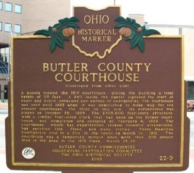
On High Street (Ohio Route 129/177), on the right when traveling east.
Butler County was created on March 24, 1803, about three weeks after Ohio became a state. Hamilton won the competition for the county seat, thanks to Israel Ludlow, Hamilton's founder. Ludlow's donation of the public square secured the county . . . — — Map (db m28546) HM
On Reily Millville Road at Cochran Road, on the right when traveling west on Reily Millville Road.
Lewis-Sample Farmstead. The farmstead shares the name of the Lewis and Sample families, two owners since European-descended settlers began moving into the Ohio County in the late 1700s. Andrew (1762-1847) and Martha Lewis (1774-1852) acquired . . . — — Map (db m157034) HM
Edward Bebb, father of William Bebb and first Welshman to settle in Paddy's Run, Morgan Township, Butler County purchased this cabin in 1801. Originally the cabin stood four miles southeast of this site on the Dry Fork of the Whitewater River. It . . . — — Map (db m24001) HM
On Monument Avenue at High Street ( Route 129/177), on the right when traveling south on Monument Avenue.
Side A: Soldiers, Sailors, and Pioneers Monument
The Soldiers, Sailors, and Pioneers Monument was planned and promoted by Butler County Civil War veterans and financed by a county levy in 1899. The monument, built of Indiana Limestone, is . . . — — Map (db m30705) HM
Side A
The dimensions of the canal channel were 26 feet wide at the bottom and 40 feet wide at the top. The depth of the canal averaged four and one-half feet. The 12 locks were 80 feet long with 14-foot wide interior chambers which could . . . — — Map (db m122419) HM
Near Oxford Millville Road (U.S. 27) 0.3 miles north of Stillwell Beckett Road, on the right when traveling north.
side A
A cemetery was established on the site in 1811 and became the final resting place for many of the area's early pioneer families. The Hanover Township Trustees obtained title to the land in 1823 from John and Anna Farnsworth, and it . . . — — Map (db m97814) HM
On High Street (Ohio Route 129/177) west of Monument Street, on the right when traveling east.
Because water was the most efficient way to transport goods, most early Ohio roads led to a navigable stream, such as the Great Miami River. Through the 1820s, much of Butler County's abundant agriculture output found its way to market on . . . — — Map (db m73593) HM
On Indiana Street at State Line Road, on the left when traveling west on Indiana Street.
The Union School 1893-2004
College Corner Ohio · West College Corner Indiana
In 1893, Ohio and Indiana constructed the first Union School on the state line separating Ohio and Indiana. For 111 years, students from both states have been . . . — — Map (db m225395) HM
On Woodsdale Road 0.4 miles east of Wayne Madison Road, on the right when traveling west.
In 1819, Christian Augspurger led a group of six German-speaking families from the Alsace region of France to establish an Amish settlement in Butler County, Ohio. This became one of the first Amish communities in Ohio and the westernmost in . . . — — Map (db m275809) HM
Front One of the few remaining covered bridges in southwestern Ohio and the only one in Butler County on its original site, this bridge was built in 1868-1869 to give access to a saw and grist mill owned by James B. Pugh on Four Mile . . . — — Map (db m86977) HM
On Heaton Street, on the right when traveling south.
Warren Gard (1873-1929), son of Samuel Z. Gard and Mary Duke, was born in Hamilton, Ohio. He established his practice in Hamilton after graduating from Cincinnati Law School and being admitted to the Ohio Bar in 1894. Gard served as Butler County . . . — — Map (db m122416) HM
On Monument Avenue, on the right when traveling south.
Author William Dean Howells (1837-1920) spent his boyhood from 1840 to 1848 in Hamilton. Called the "Dean of American Letters," Howells wrote 35 novels, 35 plays, 34 miscellaneous books, 6 books of literary criticism, 4 books of poetry, and hundreds . . . — — Map (db m28772) HM
On Bebb Park Lane 0.5 miles south of Cininnatti Brookville Road, on the right when traveling north.
Located along the Indiana state line, Governor Bebb MetroPark was established in 1961 as the fourth park in the MetroParks of Butler County park system. The park began as a 10-acre parcel, and has evolved into a 269-acre local outdoor destination . . . — — Map (db m275327) HM
On 1st Avenue east of Court Street, on the right when traveling north.
The Landing of the Welsh in Gallipolis. On April 1, 1818, six families from the Cilcennin area of Mid-Wales sailed from Aberaeron, Wales to Baltimore. The group of 36 people was led by John Jones Tirbach. From Baltimore they traveled to . . . — — Map (db m312391) HM
On Springfield Pike (Ohio Route 4) at Wyoming Avenue, on the right when traveling north on Springfield Pike.
Robert Reily, founder of the village of Wyoming in 1861. He was born June 1, 1820, the son of John and Nancy Hunter Reily of Butler County. He served as a major, lieutenant colonel and colonel of the 75th Ohio Volunteer Infantry Regiment in the . . . — — Map (db m19920) HM
On Reily Millville Road at Bunker Hill-Woods Road, on the right when traveling east on Reily Millville Road.
During the American Civil War, this was the motto of the Peace Democrats, also known as "Copperheads". Butler County was home to a large Copperhead faction during the war years. The Copperheads were led by Ohio Senator Clement Vallandigham and . . . — — Map (db m275325) HM
On South Third Street near Charles Str, on the left when traveling south.
- “I declare the earth is hollow and habitable within,” said John Cleves Symmes in summarizing his “Theory of Concentric Spheres and Solar Voids” to a doubting scientific world in the early 1820’s. His theory is commemorated . . . — — Map (db m116622) HM
First Jain Temple in Ohio
"Souls render service to one another"
The Jain Center of Cincinnati and Dayton was established on April 22, 1979 as a non-profit tax-exempt organization under the laws of the United States and the State of Ohio. . . . — — Map (db m24073) HM
On Indian Creek Road (County Route 37), on the left when traveling east.
The Indian Creek Regular Baptist Church was established in 1810 as an arm of the Little Cedar Creek Church of Brookville, Indiana. The congregation purchased three acres of land for a burial ground and church and built a log structure here in . . . — — Map (db m120291) HM
On Third Street, on the right when traveling north.
Side A
Clark Lane built this library in 1866 and donated it to the people of Hamilton two years later. The 1913 Great Miami River flood catastrophe damaged much of the building and many of its books and records. The refurbished library . . . — — Map (db m122413) HM
On Bebb Park Lane at Cininnatti Brookville Road, on the right when traveling south on Bebb Park Lane.
This pioneer cabin built in 1799 was owned by Edward Bebe, father of William and first Welshman to settle in Morgan Township, Butler County. Originally the cabin stood on the same Dry Fork Creek about 4 miles southeast of this site. Here William . . . — — Map (db m275349) HM
On West High Street (U.S. 27) at West Park Place, on the right when traveling west on West High Street.
Lynching in America. Between 1865 to 1950, thousands of African Americans were victims of mob violence and lynching across the United States. Following the Civil War, fierce resistance to equal rights for African Americans and an ideology of . . . — — Map (db m178139) HM
Near Woodsdale Road 0.5 miles east of Wayne Madison Road, on the right when traveling west.
This "sanitary" outhouse is typical of those built by the Works Progress Administration in the early 1930's and eventually nicknamed The Eleanor.
In the early 1930's our nation fell into a great depression. Many people were out of work, the stock . . . — — Map (db m275803) HM
On Woodsdale Road 0.4 miles east of Wayne Madison Road, on the right when traveling west.
The summer kitchen played a significant role in the history of the Chrisholm Farmstead. In addition to being used as a kitchen it also served as a butchering center, bakery, storage space, carriage house, and eventually a garage. The Augspurgers . . . — — Map (db m275808) HM
On Woodsdale Road (County Route 150), on the right when traveling west.
Chrisholm
This farm, Chrisholm (German for home farm of Christian Augspurger), was established in 1830 by Christian Augspurger (1782-1848), leader of the Amish Mennonite settlement in Butler County. The Amish selected this area because of . . . — — Map (db m275155) HM
Near State Steet at Roberts Street, on the right when traveling south.
During the term of Thomas Jefferson, the Embargo Act of 1807 was passed ending the importation of iron from England and Europe. Iron furnaces sprang up immediately in western Pennsylvania to supply the needs of the pioneers and cash-in on the high . . . — — Map (db m167530) HM
Near Woodsdale Road 0.5 miles east of Wayne Madison Road, on the right when traveling west.
This cemetery is the second oldest surviving Amish cemetery in Butler County, Ohio. Set aside by early Amish Pioneer Christian Augspurger, this plot of land was originally fenced by Augspurger's son, Samuel, in 1848, the year of his father's death. . . . — — Map (db m275811) HM
On U.S. 41 at County Road E 100 N, on the right when traveling north on U.S. 41.
Famous orator - Representative in Congress, 1861-66, 1869-73; U.S. Senator, 1877–1897; chief promoter of the building of the Library of Congress. — — Map (db m3232) HM
Thin black lines indicate changes in relevance. Between each pair of lines entries are ordered geographically but all have the same relevance.
* Inflectional forms of words are their plurals, singulars, and possessives as well as gramatical tenses and similar variations.