By J. J. Prats, May 2, 2010
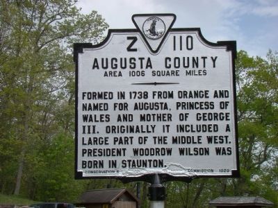
Augusta County Face of Marker
GEOGRAPHIC SORT WITH USA FIRST Geographic Sort Title Sort Marker Number Sort Marker Number Sort N Marker Number Sort T Publication Order Sort Publication Order Sort A Erected Year Sort Most Viewed Sort Most Recent-Interest Sort Most Recently Changed Sort SEE FAQ #33 FOR DESCRIPTIONS
On U.S. 250, on the right when traveling west.
On Lee Highway (U.S. 11) south of Summit Church Road, on the left when traveling south.
On Germanna Highway (State Highway 3) at Batna Road (County Route 663), on the right when traveling east on Germanna Highway.
Near George Washington Memorial Parkway (at milepost 7).
On Lorton Road, 1 mile south of Ox Road (Virginia Route 123), on the left when traveling east.
On Lorton Road, 1 mile south of Ox Road (Virginia Route 123), on the left when traveling east.
On Lorton Road, 1 mile south of Ox Road (Virginia Route 123), on the left when traveling east.
On Lorton Road, 1 mile south of Ox Road (Virginia Route 123), on the left when traveling east.
On Lorton Road, 1 mile south of Ox Road (Virginia Route 123), on the left when traveling east.
On Lorton Road, 1 mile south of Ox Road (Virginia Route 123), on the left when traveling east.
On Lorton Road, 1 mile south of Ox Road (Virginia Route 123), on the left when traveling east.
On Occoquan Regional Park Road near Ox Road (Virginia Route 123), on the left when traveling east. Reported permanently removed.
On Lorton Road, 1 mile south of Ox Road (Virginia Route 123), on the left when traveling east.
On Chesapeake Avenue (Virginia Route 167) at Hampton Roads Avenue, on the left when traveling south on Chesapeake Avenue.
On Washington Street just south of Church Street, on the right when traveling south.
Paid Advertisement
On Rockfish Gap Turnpike (U.S. 250) at Skyline Drive and Blue Ridge Parkway, on the right when traveling east on Rockfish Gap Turnpike.
On West Virginia Beach Boulevard (U.S. 58) at Llewellyn Avenue, on the right when traveling west on West Virginia Beach Boulevard. Reported missing.
Near Lincoln Street east of 3rd Street, on the left when traveling east.
On Virginia Avenue (State Highway 42), on the right when traveling south.
On Lee Jackson Highway (U.S. 11) near Raphine Road (County Route 606), on the right when traveling south.
On Warm Springs Pike (Virginia Route 42) 0.8 miles north of Mussoq Creek Road (Virginia Route 747), on the right when traveling north. Reported damaged.
Near Middlebrook Avenue (Virginia Route 252) west of South Augusta Street, on the left when traveling south.
On E Frederick Street, on the left when traveling west.
On Lee Highway (U.S. 11) south of Woodrow Wilson Parkway (Virginia Route 275), on the right when traveling south.
On Greenville Avenue (U.S. 11) at Ritchie Boulevard (State Route 275), on the right when traveling south on Greenville Avenue.
On North Coalter Street at Berkeley Place, on the left when traveling north on North Coalter Street.
Near Pacific Avenue (U.S. 60) just south of 14th Street, on the right when traveling north.
Near Lieutenant Billy Webb Avenue, 0.2 miles north of Cook Street.
On Orby Cantrell Highway (U.S. 23) just north of the traffic light for Lowes Home Improvement, on the right when traveling north.
On East Main Street (U.S. 11) near 1st Street, on the left when traveling west.
Near Voice of America Road West, 1.1 miles north of Lotzgesell Road when traveling north.
Paid Advertisement
On U.S. 60, on the left when traveling west.
On U.S. 50 east of U.S. 250, on the left when traveling west.
On U.S. 250, on the left when traveling south.
Near Interstate 94 at milepost 43, on the right when traveling west.
Near North Water Street (U.S. 12) north of Harrison Street, on the left when traveling north.
On County Route I, 0.5 miles east of County Route H, on the left when traveling north.
On Main Street (State Highway 66) at Soo Marie Avenue, on the right when traveling east on Main Street.
On Byron Street, on the right when traveling south.
240 entries matched your criteria. Entries 201 through 240 are listed above.
⊲ Previous 100