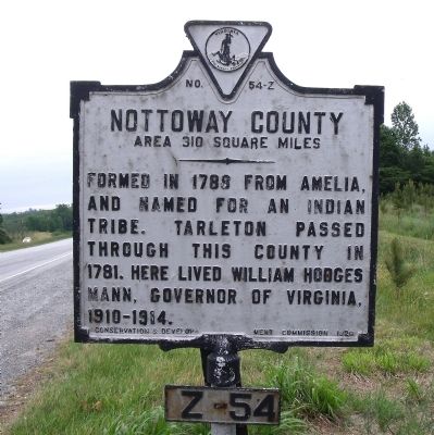
By Bernard Fisher, May 18, 2010
Nottoway County Marker (reverse)
RANKED BY RELEVANCE
On Patrick Henry Highway (U.S. 360) at Orchard Road (County Route 607), on the right when traveling east on Patrick Henry Highway.
On Free State Road (County Route 630) 0.4 miles east of Payne Lane, on the right when traveling east. Reported permanently removed.
Near Zion Hill Road (County Route 628) 0.1 miles east of McClendon Drive. Reported permanently removed.
On College Road (County Route 692) 0.3 miles south of Five Forks Road (County Route 658), on the right when traveling south.
On Otterburn Road (Virginia Route 614) 0.1 miles south of Leidig Street ( Route 634), on the left when traveling south. Reported permanently removed.
Near Campus Drive (County Route 378) near Chritanna Highway ( Route 46). Reported permanently removed.
On Fort Hill Road 1.1 miles west of Christanna Highway ( Route 46), on the right when traveling west. Reported permanently removed.
On College Drive 0.1 miles north of Windsor Avenue ( Route 46), on the right when traveling north. Reported permanently removed.
Near Lee Wayside Road near Anderson Highway (U.S. 60). Reported permanently removed.
On C G Woodson Road (Virginia Route 670) 0.2 miles north of Liberty Road ( Route 759), on the right when traveling north. Reported permanently removed.
On Legrande Avenue (Virginia Route 47) at David Bruce Avenue ( Route 40) on Legrande Avenue. Reported permanently removed.
On Tech Lane at Lunenburg Highway ( Route 40) on Tech Lane. Reported permanently removed.
On Cargills Creek Road (County Route 632) at Salem School Road (County Route 608), on the right when traveling west on Cargills Creek Road. Reported permanently removed.
On Matthews Jefferson Drive at East River Road, on the right when traveling south on Matthews Jefferson Drive. Reported permanently removed.
Near Cartersville Road (Virginia Route 45) at Columbia Road ( Route 690), on the right when traveling south.
Paid Advertisement
Near Cartersville Road (Virginia Route 45) 0.1 miles north of Ampthill Road, on the right when traveling north.
On Foster Road at Anderson Highway (U.S. 60), on the left when traveling north on Foster Road. Reported permanently removed.
Near Sycamore Drive at Boydton Plank Road (U.S. 1). Reported permanently removed.
Near 7th Avenue 0.5 miles north of Albermarle Street. Reported permanently removed.
On Rocky Branch Road (Virginia Route 636) 0.3 miles south of New Cox Road (U.S. 460), on the left when traveling south. Reported permanently removed.
Near Cowford Road (Virginia Route 651) near Mary Bethune Street. Reported permanently removed.
On Ragland Street at Watkins Avenue, on the left when traveling east on Ragland Street. Reported permanently removed.
On Jeffress Boulevard 0.1 miles east of Penick Avenue, on the right when traveling north. Reported permanently removed.
On Tidewater Avenue at West 7th Street, on the right when traveling east on Tidewater Avenue. Reported permanently removed.
On Highway Fifty Eight (U.S. 58) 0.1 miles east of Jefferson Street, on the right when traveling east. Reported permanently removed.
On Highway Forty Seven (Virginia Route 47) at Village Road ( Route 874), on the left when traveling west on Highway Forty Seven. Reported permanently removed.
On 4th Street at South Amelia Avenue, on the left when traveling west on 4th Street. Reported permanently removed.
On Mt. Nebo Road 0.4 miles Walnut Hill Road, on the left when traveling north. Reported permanently removed.
On Miller Street at 5th Street SE ( Route 9694), on the right when traveling south on Miller Street. Reported permanently removed.
On Harrison Street at Maple Lane, on the left when traveling south on Harrison Street. Reported permanently removed.
On South Jones Street 0.1 miles south of Lee Avenue, on the left when traveling south. Reported permanently removed.
Paid Advertisement
On South Main Street (U.S. 15) at 4th Street, on the right when traveling south on South Main Street. Reported permanently removed.
Near High Street (County Route 643) south of St George Street. Reported permanently removed.
On South Main Street (U.S. 15) at 4th Street, on the right when traveling north on South Main Street. Reported permanently removed.
On College Road (County Route 692) 0.3 miles south of Five Forks Road (County Route 658), on the right when traveling south. Reported permanently removed.
Near Griffin Boulevard at Barrow Street. Reported permanently removed.
On High Street (County Route 643) at Buffalo Street, on the right when traveling east on High Street.
On Farmville Road (U.S. 15) 0.8 miles south of Worsham Road (County Route 665), on the right when traveling south.
Near Vacation Lane 0.1 miles east of 23rd Street North, on the right when traveling east.
On Wells Avenue Northeast east of North Jefferson Street, on the left when traveling east.
On West Virginia Avenue (U.S. 460) just east of Lee Street (County Road T-1031), on the right when traveling east.
On College Road (County Route 692) just north of County Road 1006, on the left when traveling north.
Near West Bridge Street east of North Park Street, on the left when traveling east.
Near Hydraulic Road (County Road 743) at Hydraulic Ridge Road, on the left when traveling north.
On Henry Street Northwest north of Loudon Avenue Northwest, on the right when traveling north.
On Broad Street (U.S. 17) at Craven Street on Broad Street.
On Griffin Boulevard 0.1 miles north of South Main Street (Business U.S. 15), on the right when traveling north.
Paid Advertisement
On 13th Street (U.S. 1) near Independence Drive, on the left when traveling north.
On Farmville Highway (U.S. 15) at Cabbage Patch Road (County Route 654), on the right when traveling north on Farmville Highway.
On North Main Street (Business U.S. 301) at West Atlantic Avenue (Business Route 58), on the left when traveling west on North Main Street.
On West Colonial Trail Highway (U.S. 460) at County Route 607, in the median on West Colonial Trail Highway.
On South Main Street (Business U.S. 15) at 4th Street, on the right when traveling north on South Main Street.
On Zion Hill Road (County Road 628) 0.1 miles west of McLendon Street, on the right when traveling west.
On Holly Farms Road (Route 307) west of Sailers Creek Road, on the left when traveling west.
On Johnston Drive at Longwood Avenue, on the left when traveling south on Johnston Drive.
Near Old Courthouse Road (Route 24) 0.7 miles west of Gordon Drive, on the left when traveling west.
On Independence Drive near near 13th Street (U.S. 1), on the left when traveling west.
︽
Thin black lines indicate changes in relevance. Between each pair of lines entries are ordered geographically but all have the same relevance. * Inflectional forms of words are their plurals, singulars, and possessives as well as gramatical tenses and similar variations.
Nov. 13, 2026