26 entries match your criteria.
Entries Containing All of the Phrases «isle of wight county» AND «virginia»
The following noise* word you entered was ignored: of.
If this word is required for a successful search, go to the Advanced Searches page and use the Google Search from there.
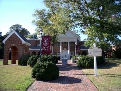
By Bernard Fisher, September 18, 2010
Isle of Wight County Courthouse
RANKED BY RELEVANCE
1 ► Virginia, Isle of Wight County, Isle of Wight — Isle of Wight County —  |
| Near Monument Circle at Courthouse Highway (U.S. 258). | |||
| 2 ► Virginia, Suffolk, Holy Neck — Z-243 — Isle of Wight County / Nansemond County — |
| On Pruden Boulevard (U.S. 460) 0.1 miles east of Ennis Mill Road (County Route 690), on the right when traveling east. | |||
| 3 ► Virginia, Isle of Wight County, Smithfield — Welcome to Fort Boykin — Established 1623 — Historic Fort Boykin — |
| Near Fort Boykin Trail (Virginia Route 705) at Morgarts Beach Road ( Route 673), on the left when traveling north. | |||
| 4 ► Virginia, Isle of Wight County, Carrollton — K-247 — Josiah Parker — (Macclesfield) — |
| On Norsworthy Drive (Virginia Route 670) at Old Georgian Lane, on the left when traveling south on Norsworthy Drive. | |||
| 5 ► Virginia, Isle of Wight County, Isle of Wight — K-260 — Boykin's Tavern — |
| Near Monument Circle at Courthouse Highway (U.S. 258). | |||
| 6 ► Virginia, Isle of Wight County, Smithfield — Fort Boykin during the Civil War — Historic Fort Boykin — |
| Near Fort Boykin Trail (Virginia Route 705) near Morgarts Beach Road ( Route 673), on the left when traveling north. | |||
| 7 ► Virginia, Portsmouth, Park View — Lieutenant William H. Cocke — |
| Near Fort Lane south of Enterprise Way, on the right when traveling north. | |||
| 8 ► Virginia, Isle of Wight County, Smithfield — History of Longleaf Pine in Virginia — |
| On Dan Smith Drive just west of Jericho Road, on the left when traveling west. | |||
| 9 ► Virginia, Sussex County, Courtland — Z-31 — Southampton County / Sussex County |
| On Plank Road (Virginia Route 35) 0.5 miles north of Big Woods Road, on the right when traveling south. Reported missing. | |||
| 10 ► Virginia, Isle of Wight County, Smithfield — Z-242 — Surry County / Isle of Wight County — |
| On Colonial Trail E (Route 10), on the right when traveling north. | |||
| 11 ► Virginia, Isle of Wight County, Smithfield — Welcome to Fort Huger — Gateway to the Confederate Capital — Historic Fort Huger — |
| Near Talcott Terrace at Lawnes Neck Drive, on the right when traveling east. | |||
| 12 ► Virginia, Newport News, Fort Eustis — Matthew Jones House — Bourbon — |
| Near Harrison Road near Taylor Avenue. | |||
| 13 ► Virginia, Portsmouth, Park View — James F. Crocker — |
| Near Fort Lane at Holladay Street, on the right when traveling north. | |||
| 14 ► Virginia, Isle of Wight County, Carrollton — 1954 Nike-Ajax Missile Site N-75L — |
| Near Nike Park Road (Virginia Route 669) 0.1 miles south of Carrollton Court. | |||
| 15 ► Virginia, Isle of Wight County, Smithfield — 34 — Fort Huger — Captain John Smith’s Adventures on the James — www.johnsmithtrail.org — |
| On Talcott Terrace at Lawnes Neck Drive, on the right when traveling east on Talcott Terrace. | |||
| 16 ► North Carolina, Washington County, Plymouth — Why Plymouth? — Willing Citizens, Opportunity, Transportation — |
| On West Water Street at Monroe Street, on the right when traveling west on West Water Street. | |||
| 17 ► Virginia, Isle of Wight County, Smithfield — African Americans at Fort Huger — Gateway to the Confederate Capital — Historic Fort Huger — |
| Near Talcott Terrace at Lawnes Neck Drive, on the right when traveling east. | |||
| 18 ► Virginia, Isle of Wight County, Carrsville — Isle of Wight County Monument to Confederate Dead — |
| On Walters Highway (U.S. 258) 0.2 miles south of Burdette Road ( Route 619), on the right when traveling south. | |||
| 19 ► Virginia, Isle of Wight County, Smithfield — Liquid Maze — Captain John Smith Chesapeake National Historic Trail — National Park Service, U.S. Department of the Interior — |
| On Jericho Road. | |||
| 20 ► Virginia, Isle of Wight County, Smithfield — The Fort's Last Private Owners — Historic Fort Boykin — |
| Near Fort Boykin Trail (Virginia Route 705) at Morgarts Beach Raod ( Route 673), on the left when traveling north. | |||
| 21 ► Virginia, Isle of Wight County, Smithfield — The Well — Historic Fort Boykin — |
| Near Fort Boykin Trail (Virginia Route 705) at Morgarts Beach Road ( Route 673), on the left when traveling north. | |||
| 22 ► Virginia, Suffolk — Civil War Militia of Suffolk and Nansemond County — |
| Near Mahan Street east of North Main Street ( Route 32). | |||
| 23 ► Pennsylvania, Philadelphia County, Philadelphia, Society Hill — Mother Bethel — 1791 — Old Philadelphia Congregations — |
| On South 6th Street at Addison Street, on the left when traveling south on South 6th Street. | |||
| 24 ► Virginia, Isle of Wight County, Carrollton — Nike-Ajax Missile Radar Control Site N-75C — |
| Near Boundary Road 0.4 miles west of Smiths Neck Road. | |||
| 25 ► Virginia, Isle of Wight County, Windsor — UT-19 — Seven Confederate Brothers — |
| On East Windsor Boulevard (U.S. 460) 0.1 miles west of Hidden Acres Circle, on the right when traveling west. | |||
| 26 ► Virginia, Newport News, Fort Eustis — Crafford House — |
| Near Harrison Road 1 mile east of Harrison Road, on the left when traveling south. | |||
Thin black lines indicate changes in relevance. Between each pair of lines entries are ordered geographically but all have the same relevance.
* Inflectional forms of words are their plurals, singulars, and possessives as well as gramatical tenses and similar variations.
* A noise word is a word that has been deemed too common to index. “The,” “to,” and “then” are examples of noise words. You will find a full list on the Advanced Searches page, in the Rules and Options link of the Keyword Search.
* A noise word is a word that has been deemed too common to index. “The,” “to,” and “then” are examples of noise words. You will find a full list on the Advanced Searches page, in the Rules and Options link of the Keyword Search.
Nov. 13, 2026