Marker Logo HMdb.org THE HISTORICAL
MARKER DATABASE
“Bite-Size Bits of Local, National, and Global History”


17 entries match your criteria.  


South Carolina, Beaufort County Historical Society Historical Markers
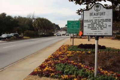
 
Beaufort Marker, moved to a new location in 2010, looking west along Boundry Street (US 21) image, Touch for more information
By Mike Stroud, January 2011
Beaufort Marker, moved to a new location in 2010, looking west along Boundry Street (US 21)
1 South Carolina, Beaufort County, Beaufort — 7-1 — Beaufort
On Boundary Street (U.S. 21) near Ribaut Road, on the right when traveling west.
2 South Carolina, Beaufort County, Beaufort — 7-10 — Beaufort Arsenal
On Craven Street, on the right when traveling east.
3 South Carolina, Beaufort County, Beaufort — 7-26 — Beaufort College
On Carteret Street (U.S. 21), on the right when traveling west.
4 South Carolina, Beaufort County, Beaufort — 7-21 — Beaufort Female Benevolent Society
On Scott Street, on the left when traveling north.
5 South Carolina, Beaufort County, Beaufort — First Fort
On Bay Street near Scott Street, on the right when traveling east. Reported missing.
6 South Carolina, Beaufort County, Beaufort — 7-22 — St. Helena's Church
On Church Street south of King Street when traveling south.
7 South Carolina, Beaufort County, Beaufort — Verdier House
On Bay Street, on the right when traveling west.
8 South Carolina, Beaufort County, Beaufort, The Old Point — 7-67 — Carnegie Library
On Craven Street at Carteret Street (Business U.S. 21), on the left when traveling east on Craven Street.
9 South Carolina, Beaufort County, Bluffton — 7-2 — Bluffton, S.C.
On May River Road (State Highway 46) at Verdier Cove Road, on the right when traveling east on May River Road. Reported missing.
10 South Carolina, Beaufort County, Frogmore — 7-32 — The Great Sea Island Storm
On Dr. Martin Luther King Drive (State Highway S-7-45), on the right when traveling south.
11 South Carolina, Beaufort County, Grays Hill — 7-5 — Battle of Port Royal Island
On Trask Parkway (U.S. 21) near Parker Drive, on the right when traveling south.
12 South Carolina, Beaufort County, Parris Island — Northern Most Known Bastion of Spanish Florida
On Balleau Wood Road.
13 South Carolina, Beaufort County, Pinckney Island — 07-19 — Charles Cotesworth Pinckney(1746–1825)
On Pinckney Wildlife Refuge near William Wilton Parkway (U.S. 278), on the right.
14 South Carolina, Beaufort County, Pinckney Island — 07-20 — Pinckney Island
On Pinckney Wildlife Refuge north of William Wilton Parkway (Route 352), on the right when traveling north.
15 South Carolina, Beaufort County, Saint Helena Island — 7-3 — Chapel of Ease
On Lands End Road (State Highway 45), on the left when traveling south.
Paid Advertisement
16 South Carolina, Beaufort County, Sheldon — 7-4 — Ruins of Old Sheldon
On Old Sheldon Church Road north of Bailey Road, on the right when traveling north. Reported permanently removed.
17 South Carolina, Jasper County, Grahamville — 27-7 — Tomb of Thomas Heyward, Jr.1746-1809
On State Highway 462, 0.1 miles south of State Highway 27-336, on the left when traveling south.
 
 
CeraNet Cloud Computing sponsors the Historical Marker Database.
This website earns income from purchases you make after using our links to Amazon.com. We appreciate your support.
Paid Advertisement
May. 22, 2024