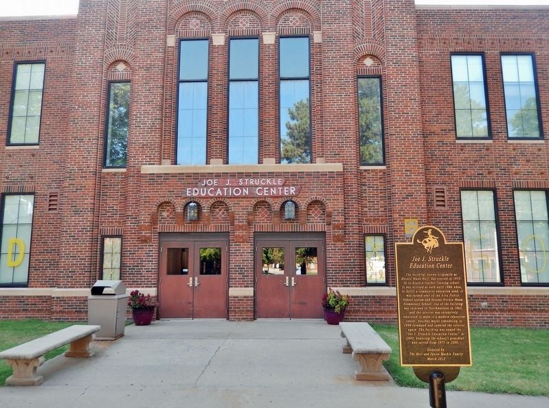
The building, known originally as Horace Mann Hall, was erected in 1935-36 to house a teacher training school. It was utilized as such until 1946 when, to fulfill a community education need, it was turned over to the Alva Public School system and . . . — — Map (db m265884) HM
The school was organized on August 30, 1894, and was first held in the dugout home of the Hulets. During the 1894-1895 school year, Dick McKeever purchased the Hulet claims and donated the southwest corner of section 24 for a school located 6 miles . . . — — Map (db m265789) HM
Monfort Drug and Book Store J.W. Monfort opened Monfort Drug and Book Store in 1894. His son, Marion, joined him in 1929. For 59 years the store was a hub for farmers, college students and families wanting textbooks, prescriptions and . . . — — Map (db m265595) HM
Nathan Boone, the youngest son of Daniel Boone, made his mark as an explorer and military officer in the early 1800s. In the summer of 1843 Boone led an exploration force of Dragoons into the western prairies. During this reconnaissance the Boone . . . — — Map (db m265700) HM
Built by Homer C. Jones, the Rialto was the realization of a showman’s dream come true. After 15 years of careful planning, the Rialto was dedicated on Sunday, August 21, 1949. It took one year, one month and 15 days to complete the structure. 315 . . . — — Map (db m265698) HM
This monument to honor the adventurous pioneers of the Cherokee Outlet Strip, marks the site of M County United States Land Office Building, Sept. 16, 1893. — — Map (db m265586) HM
Dedicated to one of Alva’s oldest family-owned businesses and its founder, Wilson Worth Starr. Mural painted by Roger Cooke, 2003 — — Map (db m265696) HM
A depiction of Alva’s celebration on the day Oklahoma became the 46th State, November 16, 1907 Sculpture by Georgia Gerber Mural by Roger Cooke, 2007 — — Map (db m265688) HM
The original Woods County Courthouse was built in 1904. In Alva’s early years, the courthouse lawn was a beehive of activity including circus parades, political speeches and 4th of July celebrations. In 1957 the old courthouse was condemned by the . . . — — Map (db m265697) HM
Camp Supply was established in Indian Territory in 1869 to support the campaign against the Southern Plains Indians. All food, ordinance and other supplies were transported to the fort from the railhead at Kiowa, Kansas by wagon or stagecoach. The . . . — — Map (db m265598) HM
Alva’s Atchison, Topeka and Santa Fe railway station, built in 1908, served as the town’s transportation hub until passenger service was terminated in 1983. Mural painted by Robbie Pierce and Jack Koonce, 2003. — — Map (db m265594) HM
Alva, Oklahoma Home of the 45th Signal Company CampaignsWorld War II — 511 Combat Days Sicily (with Arrowhead) Naples — Foggia (with Arrowhead) Anzio Rome — Arno Southern France (with Arrowhead) Rhineland Ardennes — Alsace Central . . . — — Map (db m265690) HM
The National Society Daughters of the American Revolution, Cherokee Outlet Chapter, honor the pioneers who made the Land Run into the Cherokee Outlet and those who lived here during the first 100 years. Committee: Marcile Lancaster, . . . — — Map (db m265588) HM
In grateful memory of the men of Woods County who made the supreme sacrifice in the World War. 1917—1918William G. Armstrong • Orlie Black • Francis H. Bartlow • Vester T. Brown • Henry H. Barber • Leroy Craig • Charles C. Cheek • Owen Davaney • . . . — — Map (db m265658) WM
Robert Pershing Wadlow, the tallest man in recorded history, visited Alva in 1940 on a promotional tour for the Peters Shoe Company. Driven by his father, he arrived in a 1938 Ford sedan specially modified to accommodate his size. A few months . . . — — Map (db m265596) HM
Last known encounter between Indians & U.S. Army in Okla. here Sept. 13-14, 1878. Northern Cheyenne led by Dull Knife & Little Wolf fled Darlington Agency at Ft. Reno to return to Dakotas. Crossing Woods Co. they killed 2 cowboys employed by W.R. . . . — — Map (db m181586) HM
On September 12, 1878, the bodies of Reuben Bristow and Fred Clark were found near here. It was believed they had been killed by Northern Cheyenne Indians led by Chief Dull Knife. Bristow and Clark were cowboys hauling salt for Comanche pool cattle . . . — — Map (db m19213) HM
Established Nov. 1868 by Gen. Alfred Sully with 5 companies of 3rd Inf. This was the supply base for Col. Custer's 7th Cav. Here, Dec. 2, 1868, Gen. Sheridan received Custer returning from the Battle of the Washita. Name changed to Ft. Supply 1889. . . . — — Map (db m39803) HM
Fort Supply Period 1873 to 1895
This site was chosen as the second cemetery for Fort Supply. While many soldiers and civilians were buried here, the soldiers were moved to Fort Leavenworth, Kansas in 1895 after the post was abandoned. Some . . . — — Map (db m162441) HM
Here, between 1874 and 1890, supply wagons, a daily stage coach and the U.S. Mail moved over this earliest known trail from Dodge City, Kansas to Fort Elliott, Texas. The fort, first known as "Cantonment on Sweet water" was established after the . . . — — Map (db m182287) HM
2 miles NE of here is the Cooper Paleoindian bison kill. The site was the scene of the largest Folsom (ca 10,500 years ago) bison kills known. Each event saw over 30 bison herded into a dead-end gully. Hunters on the gully rim killed the animals . . . — — Map (db m162446) HM
Boiling Springs has long been a prairie oasis. Before pioneer settlement, Plains Indians came here to camp and rest. After the Land Run of 1893, this park area was part of several pioneer homesteads. In 1925 William Shaul purchased land containing . . . — — Map (db m191656) HM
During the 1930's, one of the most important programs within President Roosevelt's "New Deal" was the Civilian Conservation Corps. The CCC enrollees were unmarried men who were between the ages of 18 and 25. Each CCC worker received a monthly wage . . . — — Map (db m191653) HM
In 1870 a supply road was established between Fort Supply and the Cheyenne-Arapaho agency in Darlington, O.T. the road and telegraph line was built as an extension of the Fort Dodge KS - Fort Supply Trail and extended to Fort Reno in 1875. In . . . — — Map (db m214654) HM
Built in 1868 as the Military Chapel at Old Camp Supply, this historic church was pulled across the plains on cedar logs by yoked oxen after the opening of the Cherokee Outlet in 1893 into Woodward to become St. John's Episcopal Church.
"A house . . . — — Map (db m191683) HM
On this 800 Block of Main Street, from his arrival in Woodward in 1893 until his untimely death in 1905, Temple Houston practiced law, spoke to rapt audiences, participated in a gunfight with the Jennings brothers, and was tried and acquitted for . . . — — Map (db m298966) HM
This park was created between 1935 and 1940 by members of Civilian Conservation Corps Company No. 2822. One of many such units organized by the Federal government during the Great Depression to provide useful employent for thousands of young men and . . . — — Map (db m191650) HM
Most CCC enrollees from company 2822 were young, unmarried, men who were between the ages of 18 and 25. Each CCC enrollee received a monthly wage of $30, of which $25 was sent home to help their family. The members of the CCC lived in work camps . . . — — Map (db m191680) HM
229 entries matched your criteria. Entries 201 through 229 are listed above. ⊲ Previous 100