Highland County. Area 422 square miles. Formed in 1847 from Pendleton and Bath, and given its name because of its mountains. The Battle of McDowell, 1862, was fought in this county.
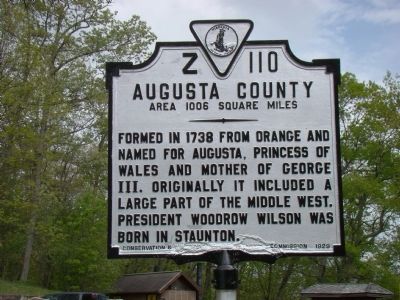
Augusta County. Area 1006 square . . . — — Map (db m30389) HM
On Lee Highway (U.S. 11) south of Summit Church Road, on the left when traveling south.
Rockingham County. Area 876 square miles. Formed in 1778 from Augusta, and named for the Marquis of Rockingham, British statesman. John Seiver, of Tennessee, was born in this county. In it took place the battles of Cross Keys . . . — — Map (db m12369) HM
On Germanna Highway (State Highway 3) at Batna Road (County Route 663), on the right when traveling east on Germanna Highway.
Just south stands Salubria, a rare estate of Georgian architecture in Virginia's Piedmont. The house is notable for its elegant proportions, fine Flemish-bond brickwork, and superb interior paneling. Salubria probably was constructed in the . . . — — Map (db m4580) HM
Near George Washington Memorial Parkway (at milepost 7).
These trees were planted
in commemoration of the
eight Presidents of
the United States
who were sons of Virginia.
George Washington 1789-1797
Thomas Jefferson 1801-1809
James Madison 1809-1817
James Monroe 1817-1825 . . . — — Map (db m241179) HM
On Lorton Road, 1 mile south of Ox Road (Virginia Route 123), on the left when traveling east.
New Life in State by State Campaigns, 1900-1920
"Set the woman on her own feet…Women must stand free with men."
Charlotte Perkins Gilman, influential author and economist who worked with Harriot Stanton Blatch in . . . — — Map (db m197339) HM
On Lorton Road, 1 mile south of Ox Road (Virginia Route 123), on the left when traveling east.
The fence you see in front of you once surrounded the White House grounds. Can you imagine standing silently beside these fenceposts, drenched in the rain, holding a heavy banner in your hand while looking directly at President Woodrow Wilson? . . . — — Map (db m197368) HM
On Lorton Road, 1 mile south of Ox Road (Virginia Route 123), on the left when traveling east.
"when the forcible feeding was ordered I was taken from my bed, carried to another room, and forced into a chair, bound with sheets and sat upon bodily by a fat murderess, whose duty it was to keep me still Then the prison doctor, . . . — — Map (db m197305) HM
On Lorton Road, 1 mile south of Ox Road (Virginia Route 123), on the left when traveling east.
The New York Times, 1917
Suffragists Will Picket White House
Plan to Post "Silent Sentinels" Bearing Emblems, Whom President Must Pass
Washington, Jan. 9 - Women suffragists, representing all parts of . . . — — Map (db m197310) HM
On Lorton Road, 1 mile south of Ox Road (Virginia Route 123), on the left when traveling east.
The Suffrage Campaign in Wartime, 1917
"Kaiser Wilson, have you forgotten your sympathy with the poor Germany because they were not self-governed? 20,000,000 American women are not self-governed."
From a . . . — — Map (db m197355) HM
On Lorton Road, 1 mile south of Ox Road (Virginia Route 123), on the left when traveling east.
Victories in 1917: New York Approved Suffrage and Prisoners Released
"Self-respecting and patriotic American women will no longer tolerate a government which denies women the right to govern themselves."
Alva . . . — — Map (db m197363) HM
On Occoquan Regional Park Road near Ox Road (Virginia Route 123), on the left when traveling east. Reported permanently removed.
Adjacent to this park a group of women was imprisoned in 1917 for demanding the right to vote. The road to Occoquan Workhouse had started in 1848.
In July 1848 at the Seneca Falls Convention in New York, officially opening the American women’s . . . — — Map (db m168931) HM
On Lorton Road, 1 mile south of Ox Road (Virginia Route 123), on the left when traveling east.
Worsening Conditions at the District of Columbia Jail and the Occoquan Workhouse
"The next lot of women who come here won't be treated with the same consideration that these women were."
Raymond Whittaker, Occoquan . . . — — Map (db m197359) HM
On Chesapeake Avenue (Virginia Route 167) at Hampton Roads Avenue, on the left when traveling south on Chesapeake Avenue.
The Hampton Roads Golf and Country Club was established in 1893 on undeveloped land purchased for speculation by Mary Frances Armstrong in 1888. This site today would extend from Hampton Roads Avenue to East Avenue, from Kecoughtan Road to Hampton . . . — — Map (db m33945) HM
On Washington Street just south of Church Street, on the right when traveling south.
Lynchburg native Cary D. Langhorne spent his early years here. A surgeon in the U.S. Navy, he was wounded in the Philippine-American War (1899-1902). During the Mexican Revolution, the U.S. government disputed the legitimacy of Mexican Pres. . . . — — Map (db m179546) HM
On Rockfish Gap Turnpike (U.S. 250) at Skyline Drive and Blue Ridge Parkway, on the right when traveling east on Rockfish Gap Turnpike.
Nelson County. Nelson County was named for Thomas Nelson, Governor of Virginia from June to November, 1871. It was formed in 1807 from Amherst County. Oak Ridge, birthplace of William Cabell Rives and later the residence of Thomas Fortune . . . — — Map (db m21701) HM
On West Virginia Beach Boulevard (U.S. 58) at Llewellyn Avenue, on the right when traveling west on West Virginia Beach Boulevard. Reported missing.
Pauline Adams, a native of Ireland who immigrated to the United States in her youth, was a woman’s rights activist who advocated a militant approach to the campaign for suffrage. The Equal Suffrage League of Norfolk was formed at her house in Ghent . . . — — Map (db m104849) HM
Near Lincoln Street east of 3rd Street, on the left when traveling east.
Dry Dock 2, first built of wood, was completed in November 1887, but rebuilt with concrete in 1933. Dry Dock 3 was completed in November 1903. Dry Dock 4 was opened on April 1, 1919, with the King and Queen of Belgium in attendance. Dry Dock 5 . . . — — Map (db m76827) HM
On Virginia Avenue (State Highway 42), on the right when traveling south.
Rockbridge County. Area 616 Square Miles. Formed in 1778 from Augusta and Botetourt, and named for the Natural Bridge. Samuel Houston and Cyrus H. McCormick were born in this county. Robert E. Lee and Stonewall Jackson are buried . . . — — Map (db m34306) HM
On Lee Jackson Highway (U.S. 11) near Raphine Road (County Route 606), on the right when traveling south.
Rockbridge County. Area 616 Square Miles. Formed in 1778 from Augusta and Botetourt, and named for the Natural Bridge. Samuel Houston and Cyrus H. McCormick were born in this county. Robert E. Lee and Stonewall Jackson are . . . — — Map (db m23760) HM
On Warm Springs Pike (Virginia Route 42) 0.8 miles north of Mussoq Creek Road (Virginia Route 747), on the right when traveling north. Reported damaged.
Rockingham County. Area 876 Square Miles. Formed in 1778 from Augusta, and named for the Marquis of Rockingham, British statesman. John Sevier, of Tennessee, was born in this county. In it took place the battles of Cross Keys . . . — — Map (db m88642) HM
Near Middlebrook Avenue (Virginia Route 252) west of South Augusta Street, on the left when traveling south.
Dr. Barnas Sears, a career educator and Baptist minister, was nearly 65 years old in 1867 when he resigned as president of Brown College in Providence, Rhode Island, and moved to Staunton.
He became the agent of the Peabody Educational Fund . . . — — Map (db m134485) HM
On E Frederick Street, on the left when traveling west.
Commemorating the Birthplace of Woodrow Wilson this enclosing wall and garden laid out as of the period of 1846 – 1857 is dedicated by the Garden Club of Virginia — — Map (db m58784) HM
On Lee Highway (U.S. 11) south of Woodrow Wilson Parkway (Virginia Route 275), on the right when traveling south.
Three and one half miles south, on Coalter Street in Staunton, is the birthplace of Thomas Woodrow Wilson, 8th Virginia-born President. New Jersey Governor, 28th President (World War I). He was chief author and sponsor of the League of Nations. . . . — — Map (db m12363) HM
On Greenville Avenue (U.S. 11) at Ritchie Boulevard (State Route 275), on the right when traveling south on Greenville Avenue.
One mile north, on Coalter Street in Staunton, is the birthplace of Thomas Woodrow Wilson, 8th Virginia-born President of the U.S., Princeton University President, New Jersey Governor, 28th President (World War I). He was chief author and sponsor of . . . — — Map (db m23076) HM
On North Coalter Street at Berkeley Place, on the left when traveling north on North Coalter Street.
has been designated a Registered National Historic Landmark Under the provisions of the Historic Sites Act of August 21, 1935 this site possesses exceptional value in commemorating and illustrating the history of the United States. U. S. . . . — — Map (db m58590) HM
Near Pacific Avenue (U.S. 60) just south of 14th Street, on the right when traveling north.
The 28th U.S. President, Wilson was Commander of the largest armed force in U.S. history during World War I. Always for peaceful resolve, his Fourteen points led to the Armistice, effectively ending the war with the Versailles Treaty. He also served . . . — — Map (db m165937) HM
Near Lieutenant Billy Webb Avenue, 0.2 miles north of Cook Street.
Veterans Day is an official United States holiday honoring the men and women who have served in military service. It is observed each year on November 11. Veterans Day coincides with Armistice Day and Remembrance Day which are also celebrated in . . . — — Map (db m210121) HM
On Orby Cantrell Highway (U.S. 23) just north of the traffic light for Lowes Home Improvement, on the right when traveling north.
Napoleon Hill was born nearby on 26 Oct. 1883.
At age 13, he became a “mountain reporter” for small
town newspapers. He left Southwest Virginia in 1908
to write magazine profiles of such business leaders as
Andrew Carnegie, Henry . . . — — Map (db m90860) HM
On East Main Street (U.S. 11) near 1st Street, on the left when traveling west.
Edith Bolling Wilson was born here on 15 Oct.
1872, where she lived with her parents Judge
William H. and Sallie White Bolling and ten
siblings. Edith Bolling married Norman Galt in
1896 and after his death in 1908 she operated
his Washington, . . . — — Map (db m44916) HM
Near Voice of America Road West, 1.1 miles north of Lotzgesell Road when traveling north.
Approximately 10,000 years ago
Dungeness Spit began to form. The Spit is formed from sand and gravel from the Olympic Mountains carried by the Dungeness River into Dungeness Bay.
Debris is also sloughed off the bluffs to the . . . — — Map (db m129716) HM
Large Federal fish hatcheries are located here. A mile east on Howard's Creek the armies of North and South fought in 1863. At "Oakhurst" three miles north the first golf club in America was organized in 1884.
Twelve Presidents, from "Old . . . — — Map (db m19361) HM
On U.S. 50 east of U.S. 250, on the left when traveling west.
To the north stood the birthplace of John Barton Payne (1855–1935), Secretary of the Interior in the cabinet of President Woodrow Wilson. From 1921 until his death in 1935, he was chairman of the American Red Cross. — — Map (db m74933) HM
Anna Jarvis was born here, 5-1-1864. Through her efforts President Wilson designated in 1914 the second Sunday in May as Mother’s Day. She died 11-24-1948 and was buried in West Laurel Hill Cemetery, Bala-Cynwyd, Pennsylvania. — — Map (db m74918) HM
Near Interstate 94 at milepost 43, on the right when traveling west.
The outbreak of war in Europe in August 1914 did not involve the United States directly. Americans expected to remain neutral in the struggle between Great Britain, France, Russia and Italy against Germany and its allies. The desire for neutrality . . . — — Map (db m2167) HM
Near North Water Street (U.S. 12) north of Harrison Street, on the left when traveling north.
This Field of Honor is a Memorial as a lasting tribute to those men and women who have served our country in war and peace. Those who survived were forever changed. Those who died were forever young in their loved ones' memories.
. . . — — Map (db m80141) WM
On County Route I, 0.5 miles east of County Route H, on the left when traveling north.
Here at Stony Hill School, Bernard J. Cigrand, 19 year old teacher and his students held the first recognized observance of “Flag Birth Day” on June 14, 1885, with a flag ten inches high, carrying 38 stars, standing in a bottle on the . . . — — Map (db m30688) HM
On Main Street (State Highway 66) at Soo Marie Avenue, on the right when traveling east on Main Street.
When World War I started in 1914, Poland was divided between the empires of Prussia, Austria, and Russia. In 1917, a Polish National Committee organized regiments of Polish-American men to fight under a Polish flag in Europe. Forty-eight . . . — — Map (db m138225) HM
On Byron Street, on the right when traveling south.
This burial plot commemorates the Polish soldiers who trained in this community from 1917 – 1919 at Camp Kosciuszko and subsequently made the supreme sacrifice – They personified the Polish soldiers’ motto: “For Your Freedom and . . . — — Map (db m140019) HM
Presented to the People
of Ireland
by
The Robert Emmet
Statue Committee
of the
United States of America
April 13, 1966
Francis J. Kane, Chairman
Ambassador Scott McLeod
Devlin W. Dormer, Esq.
Hon. Michael J. Kirwan, M.C. . . . — — Map (db m25304) HM
240 entries matched your criteria. Entries 201 through 240 are listed above. ⊲ Previous 100