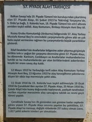
English: The 57th Infantry Regiment was formed during the Balkan War in 1912. On 1 February 1915, it was reconstituted under the command of the 19th Infantry Division as part of the Turkish Fifth Army.
The regiment showed outstanding . . . — — Map (db m85113) HM
These ten panels, mounted upon a wall facing the sea, describes the conflict between Allied and Turkish forces on the Gallipoli Peninsula in 1915.
Panel #1
English:
The Dardanelles
A good army of . . . — — Map (db m85295) HM WM
English:
This beach, 600 metres long by 20 metres wide was the life line to the Allied soldiers within the Anzac perimeter. Because of Turkish shellfire, supplies could only be landed at night and carried by men and mules along tortuous . . . — — Map (db m85219) HM
English:
By early l9l5, the Western Front in France and Flanders had reached a stalemate. The British War Council sanctioned a plan to attack the Ottoman Empire, which was fighting alongside the Central Powers, led by Germany. By . . . — — Map (db m85184) HM WM
English:
At 0430 hours on 25 April, 36 rowing boats landed the first Australian soldiers around this point and at Anzac Cove. Immediately they climbed the 100 metre hill behind you (Plugge's Plateau) and by 1000 hrs. secured a front line . . . — — Map (db m85183) HM
"Those heroes that shed their blood and lost their lives... you are now living in the soil of a friendly country. Therefore rest in peace. There is no difference between the Johnnies and the Mehmets to us where they lie side by side here in this . . . — — Map (db m85220) WM
English:
During the Gallipoli campaign, this area was known as 'Hell Spit'. To the north is the beach which became known as Anzac Cove, where some 27,000 Australian and New Zealand, British and Indian troops came ashore between 25 April . . . — — Map (db m85241) HM
English:
New Zealand and British Forces climbed from the beach under cover of darkness and launched a surprise attack on this hilltop, capturing it on 8 August 1915. They held the area immediately around the New Zealand Memorial for 2 . . . — — Map (db m85151) HM
To the glory of God and the lasting memory of 3268 Australian soldiers who fought on Gallipoli in 1915 and have no known graves, and 456 New Zealand soldiers whose names are not recorded in any other areas of the peninsula but who fell in the Anzac . . . — — Map (db m85110) WM
Turkish:
"Biz Çanakkale Yarımadasının Türklerle savaşarak ve binlerce insanımızı kaybederek kahraman Turk milletine ve onun essiz vatan sevgisine duyduǧumuz büyük takdir ve hayranlıkla . . . — — Map (db m85248) WM
English:
The coast line curls eastwards passing Ariburnu and turns North running about 160 meters along up to Nibrunesi Point (Kuchulx Kemekli). The Anzacs called the coast line here “North Beach" because of its perspective viewing . . . — — Map (db m85281) HM
English: The Allied objectives in the Gallipoli Campaign were, by capturing Istanbul, to force Turkey out of the war, to secure an ice-free sea supply route to Russia and to open another front against Germany and Austria-Hungary. The . . . — — Map (db m85111) HM
English:
"On 10th of August 1915 the British Forces of 20,000 settled into their trenches where they had spent days digging and waiting for the moment to attack and occupy Chunuk Bair, and thereby dominate the Dardanelles. The darkness . . . — — Map (db m85148) HM
English:
This key position defended vigorously by both side saw repeated attacks across this narrow ridge. The ANZAC trenches were located close to the cemetery. The Turkish trenches originated near to the raised stone memorial on your . . . — — Map (db m85145) HM
English:
The Nek is a hillock, 157 m. above sea level, located at Russell's Top. It is a very important point which connects Russell's Top - which is 700 m. high and 40-100 m. wide and extending over Plugge's Plateau on the southwest - . . . — — Map (db m85147) HM WM
English:
This was a fiercely contested part of the front-line at Anzac. A narrow passage across the ridge known as ‘the Nek' lay just below a hill designated Baby 700 by Commonwealth forces. After the Armistice. the remains of several . . . — — Map (db m85115) HM WM
Turkish:
29 Mayis
1453
Salı Sabahi
Cenevizlerin
Galata
Kolonisi
Anahtarlarını
Fatih Sultan
Mehmed
Takdim Etmiş
ve Galatanın
Teslimi
1 Haziran Cuma
Günü . . . — — Map (db m84878) HM
English:
The story of the Tunnel. which is the second oldest underground system in the World after the London Underground, started with the French engineer Eugene Henri Gavand‘s initiative. Engineer Gavand observed people shuttling between . . . — — Map (db m84829) HM
English:
The settlement increased on the shores of the Bosphorus in the period of (1703-1730) Ahmed III and brought the problem of water supply. To solve this problem, development activities were initiated but these development activities . . . — — Map (db m84831) HM
Turkish:
Galatasarayı Hamami
Tarihinden
İnşaası: Sultan Bayazıt.II.1481-1541
ilâve ve tamirler: Sultan Selim II.
avcı Mehet. IV. Ahmet.III. mahmu dı
restorasiyon Hüseyin Yumuşak . . . — — Map (db m84877) HM
English:
Alay Pavilion was the building constructed above the outer wall of Topkapl Palace for the sultans to watch the ceremonies. Before the construction of Alay Pavillion, there was a timber pavilion in 16th century. The recent . . . — — Map (db m85044) HM
English:
The Basilica Cistern was constructed by Eastern Roman Emperor I. Justinianus (527-565) in 542 A.D. to provide water requirement of the Great Palace. Due to the brilliance among the marble columns arising within the water, it was . . . — — Map (db m84740) HM
English:
Constantine I built a forum adorned with sculptures, pillars and marble arches known as the Constantine Forum in Mese which is today called Çemberlitaş. The emperor preserved the entire Strategion, the main square of the . . . — — Map (db m84739) HM
English:
Constructed in the 6th century during the reign of Emperor Justinianus, the most prosperous period of the East Roman Empire, the cistern Basilica is 70m. in width and 140m. in length. The dome, covering an area of 9800 m2, is . . . — — Map (db m84745) HM
English: In Ancient Rome, It used to be the starting point of all the roads reaching to Constantinople and the origin point used for the calculation of the distance of other cities to this city. It has the same function as the Milliarium . . . — — Map (db m84738) HM
English: The cistern was constructed in 4th century. As the Emperor Constantinus I reestablished the city, some members of the senate were forced to migrate here and Philoxenos that was one of them constructed his palace next to the . . . — — Map (db m84689) HM
English:
Firuz Aga Mosque was constructed by Firuz Aga who was Chief-treasurer of Sultan Bayezid II. The mosque was a bigger yard before the extension of Divanyolu, was constructed in 1491 as it was shown at the tablet on its door. The . . . — — Map (db m84948) HM
English: German Fountain is a monument dedicated to the second visit of the Prussian King and German Emperor Wilhelm II in 1898. The monument, which was presented in the name of Turkish-German friendship, extending its function of being a . . . — — Map (db m84692) HM
English: The obelisk was originally set up by Tutmoses III of the 18th Dynasty of Egypt in close to 1450 BC along with a similar one in front of the Temple of Amun-Re at Karnak.
Inscribed on the obelisk is an Egyptian hieroglyph script, . . . — — Map (db m84711) HM
English: St. Euphemia who was known to be a saint in the era of Ancient Chalcedon, was killed because of her religious belief on 16 September 303. Euphemia was buried within a martyrion (burial place), out of the city in Chalcedon, done by . . . — — Map (db m84691) HM
English: Walled Column also known as Walled Obelisk is one of three ancient monuments, which has survived to the present day. In the middle of the Hippodrome, there was a set that bisects race space and called as "spina" in Roman period . . . — — Map (db m84710) HM
English:
This place belongs to "The Foundation of the Sons and Servants of Great Turkish Admiral Hayrettin (Barbarossa) Pasha." The sailors of the Pasha were resting here without losing sight of the sea. In the XVI Century, one of the . . . — — Map (db m84709) HM
English:
Gulhane Park used to be the exterior yard of Topkapi Palace during the
Ottoman Period, encompassing rose gardens and a grove.
Gulhane was landscaped and transformed into a park in 1912 during the period of Cemil Topuzlu, . . . — — Map (db m85041) HM
English:
The present Ayasofya is the third building of the same name that was constructed in the same place.
The First Great Church serving as the cathedral was constructed by Emperor Constantius (337-361) in 360; it had a basilica . . . — — Map (db m84754) HM
English: This building that was one of the great and gorgeous buildings of Ottoman bathhouses in Istanbul, was constructed by Hurrem Sultan in 1556-57. The architect of the building, that was called "Hagias Sophia Bathouse", was Architect . . . — — Map (db m84632) HM
English:
They are the defensive structures, 7620 m in length, built by the decree of the Emperor of the Eastern Roman Empire Theodosios II (408- 450), to protect Constantinople from hostile attacks. The walls border the peninsula on the . . . — — Map (db m84815) HM
English: The Fountain was constructed by Mimar Ahmed Aga on the order of Ahmed III following the recommendation of Nevsehirii Damat
Ibrahim Pasha, replacing a Byzantine fountain named Perayton. The fountain which is one of the most . . . — — Map (db m84610) HM
English: The church built by the Emperor Theodosios II (408-450) on a basilica plan covered by a wooden-roof was opened for worship in 415. It was destroyed by fire during the Nike Revolt against the Emperor Justinian (527-565).
A . . . — — Map (db m84755) HM
English:
The building was constructed by the Architect Ahmed Agha in 1608. The octagonal shape of the tomb is covered by a central dome, with a large main hall in the middle and two lateral spaces the entrance.
There are mural . . . — — Map (db m84756) HM
English:
It is the first burial construction in the graveyard of Ayassofya made by the Architect Sinan, in 1577. The external walls of the building are covered with marble panels and there is a three-arched small porch (riwaq) at the front. . . . — — Map (db m84757) HM
English: Topkapi Palace was the resident of Ottoman sultans, and center of state management and education. Mehmed the Conqueror ordered the construction of a palace in Bayezid, at the location of Istanbul University at the present that would . . . — — Map (db m84609) HM
English:
The construction of this building, the largest post office of Turkey, was started in 1905, to serve as the building of Ministry of Post and Telegraph.
The construction was completed in 1909 and the name of the building was . . . — — Map (db m84980) HM
English:
It was the building that was constructed by Sultan Osman III. in 1756 and the first official building for the grand vizier. The building faced several fires and was reconstructed every time after the fires.
In the first . . . — — Map (db m85033) HM
English:
The structure is one of the examples of convergence of Western eclecticism seen in especially 19th century Istanbul and the regional and national stylistic
patterns. The building was constructed as a terminal when Roumeli Railway . . . — — Map (db m85075) HM
English:
The ”March 16th Martyrs" is an event that took place on 16th March 1920 when the military station in Şehzadebaş was raided and six soldiers killed during the British occupation of Istanbul. After the Armistice
of . . . — — Map (db m84857) HM
English:
This building is one of the first construction works in the city after the conquest of Istanbul. according to its epigraph. The place where Şimkeşhane (a place where thread was produced for fabric) was built, used to be . . . — — Map (db m84950) HM
English:
The marble pieces that are located here belong to the Triumphal Arch and the Forum built by and named after the last emperor of the Roman Empire; Theodosius the Great (4th Cent. A.D.). The Triumphal Arch was situated on the corner . . . — — Map (db m84952) HM
English: Suleiman the Magnificent (1494, Trabzon - 1566, Szigetvár), was the tenth Sultan of the Ottoman Empire and the 89th Caliph of Islam. In the west, he was known as Suleiman the Magnificent and in the east, he was known as Sultan . . . — — Map (db m84860) HM
English:
Rustem Pasha, who was both the grand vizier and son in law of Suleiman the over the Masjid of Haci Halil. Rustem Pasha Mosque is a recherché work of Mimar Sinan with its mosque, shops, inns, and fountains. The mosque is built in a . . . — — Map (db m84812) HM
English:
The construction of the bazaar began in 1597 by order of Safiye sultan, the wife of the Ottoman Sultan Murat the 3rd and the mother of Sultan Mehmet the 3rd.
67 years later, it was completed by order of Hatice Turhan Sultan, . . . — — Map (db m84814) HM
English:
Mimar Sinan was the head-architect during the periods of Kanuni Sultan Suleyman, Selim II and Murad Ill. He had a very important role on designing and building the architectural masterpieces those were symbolizing the power of the . . . — — Map (db m84876) HM
English:
This building is a social complex constructed by Mimar Sinan (Sinan the Architect) on the order of Suleiman the Magnificent (1550-1557). The Süleymaniye Mosque is at the center of the social complex constructed on a high hill . . . — — Map (db m84862) HM
English: Mausoleum of Sultan Ahmed I (1603-1617) is located at the northeast part of Sultanahmet Kulliye. There is a darülkurra (a part of a madrasah) behind this mausoleum surrounded with wall and a building on the corner, in front of . . . — — Map (db m84635) HM
English: Bucoleon Palace is a Byzantine coastal palace. It is located on the Marmara Sea shore, at Catladikapi location between Cankurtaran and Kumkapı today in the east of Little Hagia Sophia. Only the ruins of the palace have survived . . . — — Map (db m84979) HM
English: It is a Bronze monument which is well-known under the name of Serpentine Column survived to the present day from the Roman Hippodrome.
While I. Constantine's establishing the
Constantinople; i.e. the new capital of Rome, he . . . — — Map (db m84712) HM
English:
The mosque that is situated near Kahirpapi in Fenerti Street is also known as "Aga Mosque.” The architect of the mosque which was built for Agha Babu's-saade (gate of felicity) Mahmund Agha, is Mimar Sinan. Having built by . . . — — Map (db m86075) HM
English:
This mosque was dedicated to one of the Princes of Salesman the Magnificent, who died young: Sehzade Mehmed, the son of Suleyman and Hurrem was born in 1521 and died in 1543. Some believe that Sinan, was building it for Suleyman, . . . — — Map (db m85077) HM