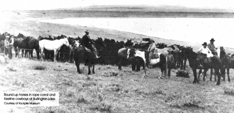
In 1891 when Gillette was founded, day-to-day living revolved around the railroad and surrounding ranches. The northern boundary of the City at that time was Burlington Lake where cattle were led to drink when livestock was moved by railroads. From . . . — — Map (db m306371) HM
The Chicago, Burlington and Quincy Railroad proposed a canal system that diverted water from Donkey Creek to Stone Pile Creek and from Stone Pile Creek into Burlington Lake. Construction began in 1907 and was completed in 1908. During construction, . . . — — Map (db m306405) HM
At the center of McManamen Park is a 10-acre lake, dredged in 1987 deep enough to hold water all year long. An additional 40-acres is dedicated to overflow that fills with water in wet years. Turning Burlington Lake into the McManamen Park “prairie . . . — — Map (db m306440) HM
In 2000, the Gillette City Council considered banning dogs from McManamen Park from March 1 to October 1 during the nesting season. The shallow water, which provides a source of food and the nesting habitat consisting of areas of relatively . . . — — Map (db m306468) HM
Fred Grant Hicks, born in Ohio, emigrated to Wyoming in 1908 to work for the Burlington Railroad. The Hicks homestead was north of Burlington Lake. He was the roundhouse foreman for twelve years. In 1932 he and his wife Florence purchased the . . . — — Map (db m306470) HM
Bede McCann was hired quite often in the summer time to use a team and scraper to clear the weeds and grass out of the Burlington Ditch. He also mowed the right-of-way along Highway 14-16 and planted the evergreen trees along the highway and train . . . — — Map (db m306494) HM
The ditch was prone to flooding during heavy rains. One of the worst floods was in August 1912 when two inches of rain fell in two hours. Gillette Avenue flooded as well as the many businesses and homes in the area. The sidewalks which were made of . . . — — Map (db m306495) HM
Flood waters from the overflowing Burlington Ditch caused thousands of dollars in damage after rapidly melting snow overflowed between Kendrick and Carey Streets in January 1943. The ditch at this point was eight feet deep. Some of the heaviest . . . — — Map (db m306496) HM
In September 1943, officials of the Chicago, Burlington and Quincy Railroad were negotiating with the City of Gillette for disposal of the Burlington Ditch. There was an original offer to the city that was turned down; details of the original offer . . . — — Map (db m306497) HM
By October 1943, negotiations were completed where the City of Gillette took over the CB&Q water ditch, according to Mayor Roy Montgomery. Under the terms of the agreement, the city received title to all the land through which the ditch ran, . . . — — Map (db m306292) HM
In September 1945, with the conclusion of the war and the impending return of hundreds of men and women, the City administration made plans to improve Gillette and provide employment for all who wished to return and live here. The city was prepared . . . — — Map (db m306279) HM
A concrete walkway was finished in 2013 around Burlington Lake at McManamen Park. The walkway was made of concrete to allow easier access for wheelchairs and to make the path easier to walk in poor weather. The walkway is10 feet wide and 7,400 . . . — — Map (db m306498) HM