1860 -
On November 7,1861 a flotilla of U.S. warships steamed into Port Royal and the "Cotton Kingdom" came to a swift and thunderous end. The planters were forced to flee inland, many never to return, abandoning homes, lands and slaves. . . . — — Map (db m5941) HM
1520 - 1711
In 1520 the Spaniard, Francisco Gordillo, sailing from Hispaniola, stopped near Port Royal Sound long enough to call the place Santa Elena. Fourty-two years later, in 1562, Jean Ribaut and his French Huguenots named the . . . — — Map (db m5886) HM
During the Colonial period the Beaufort district grew and prospered. Rice was produced for export on the mainland, indigo in the sea islands, shipbuilding flourished. The Parish System developed as the political basis and Beaufort competed with . . . — — Map (db m5935) HM
Welcome to Reconstruction Era National Historical Park. This unit of the national park system was established in January 2017 to preserve and interpret the resources and complex national stories of Reconstruction — African Americans' quest for . . . — — Map (db m227256) HM
The Baptist Church of Beaufort descends from Euhaw Baptist Church on Edisto Island. In 1794 the first meeting house was built on this site. In 1795 Henry Holcombe moved to Beaufort and became the first mission pastor. The Beaufort Baptist Church . . . — — Map (db m133292) HM
Erected in 1798 and rebuilt in 1852, the Beaufort Arsenal was the home of the Beaufort Volunteer Artillery, commissioned in 1802, which had its roots in an earlier company organized in 1776 and served valiantly in the Revolutionary War. The BVA was . . . — — Map (db m5664) HM
Beth Israel (House of Israel) Congregation was founded and chartered in 1905. Beaufort's Jewish community dates before the American Revolution, but grew most rapidly from the 1880s to the 1930s as more families arrived from Eastern Europe. . . . — — Map (db m133375) HM
This church, founded in 1865, grew out of an antebellum praise house for black members of the Baptist Church of Beaufort. During the Civil War, after the Federal occupation of the town, it hosted a school for freedmen. Rev. Arthur Waddell . . . — — Map (db m103224) HM
Port Royal Agricultural School. The Port Royal Agricultural School, later the Beaufort County Training School, operated nearby 1901-1955. Offering vocational and academic education for blacks, it was founded by Beaufort citizens led . . . — — Map (db m301180) HM
This Greek Revival church, built In 1846, dedicated as "St. Peter the Apostle Catholic Church," Is the oldest Catholic church in Beaufort County. Michael O'Connor (1798-1850), a native of Ireland who came to Beaufort In 1822, built it and deeded . . . — — Map (db m133312) HM
In Oct. 1943, the U.S. Army opened a prisoner-of-war (POW) camp near here on Pigeon Point Road. It was one of more than twenty POW camps built in S.C. during World War II to hold Axis prisoners. Around 250 Italian soldiers arrived here from Camp . . . — — Map (db m301189) HM
This site was the starting point of the Great Fire of 1907, one of the worst disasters in the history of Beaufort. On Jan. 19, a fire started around 1:30 p.m. in F.W. Scheper's barn south of here and move into a large store at this corner. The . . . — — Map (db m219671) HM
Near the old halfway house, in the vicinity of Grays Hill, on February 3, 1779, a force of South Carolina Militia, Continentals, and volunteers, including men from Beaufort, under General William Moultrie, defeated the British in their attempt to . . . — — Map (db m14738) HM
A year after the abandonment of Santa Elena in 1575, Spain, reestablished its colony on Parris Island. Fearing renewed Indian attacks upon their return, the Spanish brought with them a prefabricated fort, ready to assemble. After six days of . . . — — Map (db m20936) HM
Built 1745-55. Burned 1779 by British. Rebuilt 1826. Burned 1865 by Federal Army. Named for ancestral home of the Bull family in Warwickshire, England.
Annual Services
Second Sunday after Easter — — Map (db m26366) HM
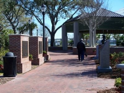
Beaufort 300
We celebrate and recognize the proud citizens
who gave generously to create and erect
these monuments to honor
Beaufort's 300th Birthday
January 17th 2011.
(Plaque 1)
Prior to the founding of . . . — — Map (db m67284) HM
The Society, founded in 1814 to educate and provide relief for destitute children, built this
house in 1895 and leased it for many years, using the income to help the needy. Tenants included the Clover Club, which operated a circulating library . . . — — Map (db m5681) HM
Berean Church. Berean Presbyterian Church was founded by Samuel J. Bampfield, an influential African American political figure during Reconstruction. Bampfield served in the S.C. House of Representatives, was Beaufort's postmaster, and clerk . . . — — Map (db m133351) HM
John Mark Verdier
1759-1826
Builder of this house
1795-1800
General Lafayette spoke to the people
of Beaufort from this portico
March 18, 1825 — — Map (db m19644) HM
Beaufort Colored School opened at this site in 1867. The school was housed in a two-story frame residence acquired by thirteen free-born and previously enslaved Black men who served as the property's trustees. It was first staffed by northern . . . — — Map (db m301217) HM
Methodism in Beaufort Co. dates to the 1730s when denomination founder Rev. John Wesley visited the area. Methodist preachers in antebellum Beaufort worked primarily among local enslaved people. In c. 1882, white residents formed a union church . . . — — Map (db m301221) HM
Prior to the Civil War, Beaufort was home to some of South Carolina's wealthiest citizens who had grown rich from the Sea Island Cotton harvested by the people they enslaved. In 1863, after more than a year of US Military occupation, the prewar . . . — — Map (db m227253) HM
[Front]:
Born in South Carolina, Pinckney was educated in England and served in the First and Second Provincial Congresses. A commander in the Revolution, he later served in the SC General Assembly, signed the US Constitution, and was . . . — — Map (db m30536) HM
[Front]:
Inhabited for some 10,000 years, Pinckney Island was known as Espalanga, Look–out, and Mackey's prior to about 1775. Alexander Mackey received two Proprietary grants for land on the island in 1710. Charles Pinckney later . . . — — Map (db m6611) HM
Bath, oldest town in North Carolina, was established in 1705. The first settlers were French Huguenots from Virginia. Among the early English inhabitants were John Lawson, author of the first history of Carolina (1709) and Christopher Gale, Chief . . . — — Map (db m67574) HM
Beaufort community activist Abbie Holmes Christensen founded the Port Royal Agricultural and Industrial School for young African American students near this site in 1902. The school was modeled on Booker T. Washington's Tuskegee Institute. . . . — — Map (db m301184) HM
Shown on the 1820 Beaufort District map by Vignoles and Ravenel, Gillisonville had a free school by 1831, and a post office in 1840. The seat of Beaufort District from 1840 to 1860, Gillisonville was burned by General William T. Sherman's army on . . . — — Map (db m4674) HM
1749 established First headmaster
1786 Beaufort Society-St Helena Society chartered by the state to foster educational endeavor
1795 St Helena-Beaufort Societies combined Resolved to "build a stately pile to the muses to be . . . — — Map (db m301190) HM
Native Americans on Parris Island
People have been living on Parris Island for over 4,000 years. Today, the prehistoric sequence is divided into four major
periods. Each is defined by the lifeways of the time.
Because these people . . . — — Map (db m20601) HM
In memory of the first person, a young girl whose name is unknown. Buried here about 1760. The story goes that she was visiting the Lesly family and died as a result of injuries sustained while they were making lye soap. John Lesly and his . . . — — Map (db m18756) HM
[Front]:
This cemetery, sometimes called Upper Long Cane Cemetery, dates from 1760. It includes the graves of some of the most prominent families of this area from the Colonial era to the present. The first marked grave is the field . . . — — Map (db m50740) HM
Thin black lines indicate changes in relevance. Between each pair of lines entries are ordered geographically but all have the same relevance.
* Inflectional forms of words are their plurals, singulars, and possessives as well as gramatical tenses and similar variations.