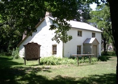
Born in Detroit to Irish immigrant parents, Curtin came to Milwaukee in 1837 to join his mother’s family the Furlongs and settle on a farm in Greenfield. In the 1840’s the Curtins moved into this typically Irish stone house described in Curtin’s . . . — — Map (db m34760) HM
Near here, at the foot of Huron (now Clybourn) Street, the first cargo pier in Milwaukee harbor was built by Horatio Stevens, Richard Owens, Amos Tufts and J.G. Kendall during the winter of 1842-43. The first vessel to dock at North Pier was the . . . — — Map (db m31137) HM
Near here a Civil War training camp was built in August 1861. Named Camp Holton, Camp Sigel and finally Camp Reno, its boundaries were Prospect and Bartlett Avenues and Lafayette and Royall Places. Six Wisconsin infantry regiments, almost 7,000 men, . . . — — Map (db m37272) HM
Dedicated to Muskego’s most illustrious pioneer and first European settler, Luther Parker, who brought his wife Alletta and five children to Muskego by horse and wagon in 1836. Luther Parker was one of several responsible for secession of Waukesha . . . — — Map (db m43612) HM
In this east-of-the-river locale then known as Juneautown, the first stage of development transformed a wilderness into a village—in less that a decade. The area was still swampy, rugged forest in the early 1830s. Solomon Juneau, Milwaukee’s . . . — — Map (db m56398) HM
In the early 1800s, a young French Canadian named Solomon Juneau came to work in Milwaukee and met and married his boss’s daughter, Josette Vieau, who was of French and Menominee ancestry. The couple built a cabin for their family on the northwest . . . — — Map (db m58169) HM
On this site, the City of Milwaukee commemorates the life, history and continuing impact of Wisconsin's first lady of civil rights, the Honorable Vel R. Phillips.
Born Velvalea Hortense Rodgers in 1924 on Milwaukee's south side, Vel . . . — — Map (db m288931) HM
Ho-Chunk histories indicate that this area has long been an important gathering place known as Tee Sisikeja (Bad Waters Village). Here, ancestors of the Ho-Chunk constructed burial sites for loved ones in the form of mounds, a practice that dates . . . — — Map (db m208429) HM
“Keep hopping, hoeing and hoping” said an editorial in 1867 when hops were selling for 50¢ a pound, pickers by the thousands worked in the fields, merchants were selling silks, laces, paisley shawls and grand pianos, and farmers were . . . — — Map (db m52853) HM
The eastern edge of downtown Milwaukee, the lakeshore itself, was very close to this spot until the early 20th century. If you were standing here before 1917 you would be standing very near the water’s edge. Between 1917 and 1937, Milwaukee filled . . . — — Map (db m56832) HM
Known until 1916 as Government Hill because it was used for government surveying purposes, Lapham Peak is the highest point in Waukesha County at 1233 ft. It was purchased by the state in 1905 as part of the farms acquired for the Statesan . . . — — Map (db m220295) HM
This site has been used for County purposes since Waukesha county was created (1846). Site of first courthouse (built 1846-1849), jail (1847) & office building (1860). New limestone Richardsonian Romanesque courthouse built on same site (1893). New . . . — — Map (db m36842) HM
In 1844, Oliver Damon, wheelwright and cabinet-maker, migrated from New Hampshire to what is now Wauwatosa. He and his son-in-law, Jonathan Warren, built this house using oak and black walnut from land he purchased in 1841. In 1846 Damon’s son, . . . — — Map (db m93500) HM
The Root River system began forming about 20,000 years ago when Wisconsin’s glaciers began to retreat. Starting in eastern New Berlin, it flows through southwest Milwaukee County before entering Lake Michigan at the city of Racine (French for . . . — — Map (db m81350) HM
Civil War Dead
An estimated 700,000 Union and Confederate soldiers died in the Civil War (1861-1865). As the death toll rose, the U.S. government struggled with the urgent but unplanned need to bury fallen Union troops. This propelled the . . . — — Map (db m98502) HM WM
The seven-mile Hank Aaron State Trail begins at the Lake Michigan shore, continues along the course of the Menomonee River, and connects at its west end to Milwaukee County's Oak Leaf Trail at Doyne Park. The Trail provides a link from Lake Michigan . . . — — Map (db m141472) HM
Lime production was an important nineteenth century industry in southeastern Wisconsin, primarily because the region’s geology provided abundant Silurian dolomite rock that was easily quarried. High quality lime, used mainly in mortar and plaster, . . . — — Map (db m37508) HM
Alonzo Robinson, Jr. was the first Black architect licensed to practice in Wisconsin. Robinson grew up in Delaware. After graduating from Howard University in Washington, D.C., he was hired by the City of Milwaukee in 1954. He also established his . . . — — Map (db m314589) HM
Welcome to Vel R. Phillips Plaza
On this site, the City of Milwaukee commemorates the life, history and continuing impact of Wisconsin's first lady of civil rights, the Honorable Vel R. Phillips.
Born Velvalea Hortense . . . — — Map (db m292070) HM
Built about 1844 by Benjamin Church, a pioneer carpenter and builder, in the Kilbourntown section of early Milwaukee. With its clean lines and fluted Doric columns, the house is an excellent example of Greek Revival architecture. Its construction . . . — — Map (db m47857) HM
The depth of the old quarry is about 45 feet, and its area is 23 acres, so you can see that a great quantity of stone was removed from it. Mules pulled rock-filled carts along tracks from various places in the quarry to one central location, a ramp, . . . — — Map (db m118831) HM
Dr. Erastus B. Wolcott was an originator of the idea for a national soldier’s home in Milwaukee.
A spirited leader in medicine, business and government, he was state surgeon-general during the Civil War and an ardent advocate for what is now the . . . — — Map (db m77415) HM
Between 600-1200 this was the site of the Effigy Mounds built by Native American people living here during the Woodland period. There were 7 mounds in geographic shapes and one giant turtle mound. These earthen mounds were lost under new . . . — — Map (db m175112) HM
Thin black lines indicate changes in relevance. Between each pair of lines entries are ordered geographically but all have the same relevance.
* Inflectional forms of words are their plurals, singulars, and possessives as well as gramatical tenses and similar variations.