On Fairview Street, 0.4 kilometers east of Maple Avenue, on the right when traveling west.
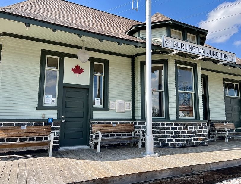
On Tuesday March 1st 1898, a 4-coach Toronto-bound passenger express train departed Hamilton Stuart Street Station. At Burlington Junction, a 24-car coal train was parked on the siding, north of the double-tracked main line, waiting for the express . . . — — Map (db m243803) HM
Near Guelph Line, 0.2 kilometers north of Pinemeadow Drive.
Ireland House on Oakridge Farm was built in 1837 by Joseph Ireland, an immigrant from Yorkshire, England.
Constructed of local fieldstone, this house was the home of four generations of the Ireland family. Designated under the Ontario Heritage Act . . . — — Map (db m243813) HM
On Lakeshore Road, 0.4 kilometers west of Brant Street, on the right when traveling west.
St Luke's Church was built in 1834 on land originally patented by Chief Joseph Brant. Consecrated in 1838 by the Right Reverend C. J. Mountain, Anglican Bishop of Quebec, the church was a simple two-storey, frame building, with tower plain Gothic . . . — — Map (db m233233) HM
This important botanical garden is distinguished by its first class horticultural collection. Originating in the late 1920s, it developed as a series of discrete gardens and a wildlife conservation area within an urban context. Some of . . . — — Map (db m221298) HM
On Lakeshore Road at Burlington Avenue, on the right when traveling east on Lakeshore Road.
Erected by the Burlington
Horticultural Society
in honour and memory
of
Spencer Smith
for his outstanding contribution
and leadership in the
beautification of Burlington
25 years on the Executive
during . . . — — Map (db m243617) HM
On Lakeshore Road, 0.1 kilometers east of Maple Avenue, on the right when traveling east.
Kilometre 3582
Burlington July 13, 1980
Terry Fox
Marathon of Hope
"Even if I don't finish, we need others to continue.
It's got to keep going without me"
Burlington may not have been the beginning or the end of the Marathon of Hope, . . . — — Map (db m243612) HM
On Lakeshore Road at North Shore Boulevard East, on the right when traveling south on Lakeshore Road.
The original house on this site was built about 1800 by the famous Mohawk chief Joseph Brant (Thayendanegea). Two years previously Captain Brant had been granted some 3500 acres of land in this area for his military services to the Crown during . . . — — Map (db m233215) HM
On Lakeshore Road, 0.1 kilometers east of Maple Avenue, on the right when traveling east.
This is the site of the famous Brant Inn where top North American entertainers and Big Bands from the 1930s to the 1960s performed. Crowds of well over a thousand people would fill the dance floor on a typical night. Music from the Brant Inn was . . . — — Map (db m243616) HM
On Brant Street at Ontario Street, on the right when traveling south on Brant Street.
In 1798 Joseph Brant, the celebrated Mohawk War Chief, was given a Crown grant of 3,450 acres in this area. James Gage purchased land from the Brant Tract in 1810, and laid out a town site at the northern end of Burlington Beach from Brant Street . . . — — Map (db m221366) HM
On Brant Street at Elgin Street, on the right when traveling north on Brant Street.
Before cars, buses and the Queen Elizabeth Way, Burlington residents could get around using a futuristic intercity streetcar system! The Hamilton Radial Electric Railway (HRER) started operating in 1896, with service to Burlington beginning in . . . — — Map (db m243609) HM
On Tuck Drive, 0.1 kilometers north of Spruve Avenue, on the right when traveling north.
At the 1954 Royal Agricultural Winter Fair in Toronto,
William E. Breckon of Burlington won the World Wheat
Championship with grain grown on his Nelson Township farm
about two miles north-east of here. He led the white winter
wheat class seven . . . — — Map (db m243606) HM
On Plains Road East at Waterdown Road, on the right when traveling west on Plains Road East.
The intersection of Plains Road, Waterdown Road and Lasalle Park Road has always been a hub of activity and enterprise. The area surrounding these corners is rich in history and fabled for its market gardens. The settlement of Burlington Plains was . . . — — Map (db m243820) HM
Near North Shore Boulevard at Las Salle Park Boulevard.
LA SALLE AT THE HEAD OF THE LAKE
In 1669 René-Robert Cavelier de La Salle, intent on reaching the Ohio River in order "not to leave to another the honour of finding the way to the Southern Sea, and thereby the route to China”, set out on . . . — — Map (db m221304) HM
On North Shore Boulevard West, 0.1 kilometers east of La Salle Park Road, on the right when traveling east.
Built in 1917 by The City of Hamilton on the former Wabasso Park Lands acquired in 1913, as a combination dance and picnic Pavilion. Its form of open verandah set between two arcaded pavilions decorated with pilasters, is characteristic of the Art . . . — — Map (db m243825) HM
On Plains Road West, 0.4 kilometers east of Botanic Drive, on the right when traveling east.
This granite post marked the 15 Mile point of the Hamilton
Herald "Around the Bay" Road Race, first run on Christmas Day 1894; it is the oldest footrace in North America. To this day runners pass this post on their way to the race finish in . . . — — Map (db m242275) HM