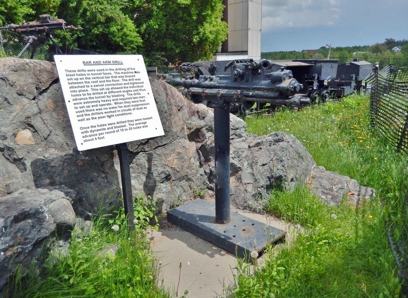
These drills were used in the drilling of the blast holes in tunnel faces. The machine was set up on the vertical bar that was braced between the roof and the floor. The drill was attached to a swivel connection and tightened into place. This set . . . — — Map (db m245397) HM
These small motors enabled trains of cars to be hauled to the dump points underground together instead of being pulled or pushed one at a time by a miner. The batteries were lead/acid and required charging up every day at underground charging . . . — — Map (db m245496) HM
This park is dedicated to the memory of Bruce Lonsdale for his outstanding contribution to the town of Cobalt and also to the citizens of the federal riding of Temiskaming. Bruce was born in Cobalt on November 10th 1949. His political career . . . — — Map (db m245497) HM
A time capsule was placed in this spot on August 06, 2006 to commemorate 100 years of incorporation for the Township of Coleman and the Town of Cobalt. To be opened August 6, 2056. — — Map (db m245396) HM
[English] Cobalt played a decisive role in the evolution of hard-rock mining in Canada. Between 1903 and the 1920s, the district’s rich veins triggered a mining boom which attracted international attention and led to Cobalt's . . . — — Map (db m208433) HM
About 900 yards southwest of here, on August 7, 1903, two lumbermen seeking timber for railroad ties made the initial discovery of the Cobalt silver camp. Named for its discoverers, the McKinley-Darragh mine operated from 1904 to 1927. In the rush . . . — — Map (db m219784) HM
[English] This railway station was built in 1905 and expanded in 1906 and 1908. A final expansion was started in 1909 and completed in 1910. The silver mines were a magnet for thousands of people and tons of supplies most of which . . . — — Map (db m245704) HM
[English] Cobalt Street offers a good example of frontier style mining architecture. Most of the houses date back to the earliest days of the camp. Settling was easier in the area as people got off the train and headed past the . . . — — Map (db m245910) HM
This type of loader replaced the miner’s shovel and greatly increased production underground. Use of these machines meant that larger mine cars could be used which in turn meant bigger tunnels, and more ore could be moved. Mucking machines are . . . — — Map (db m245399) HM
The deep gash in this hillside is all that remains of silver vein No. 96. The vein was originally discovered in 1908 by the Nipissing Mining Company Limited using an exploration method called trenching. Trenches are simply shallow channels dug down . . . — — Map (db m44574) HM
These cars were generally too big for handtramming and were normally used in TRAINS pulled by BATTERY LOCOS. The cars were either loaded by a mucking machine or by a CHUTE and the car then trammed to the DUMP. The car body was pushed over sideways . . . — — Map (db m245494) HM
[English] Silver has been an important mineral product for Canada’s economy ever since the Cobalt boom which followed the discovery of rich veins of the metal near here in 1903. Although the production of the Cobalt silver mines began to . . . — — Map (db m208443) HM
[English] The idealists are flocking in by the trainload from every corner of the globe, for the fame of this wonderful Silver City has spread far. Some are old-time California placer miners of Arizona and Sonora. Not a few are from . . . — — Map (db m245801) HM
[English] When the Cobalt boom started, the Ontario Government was completely unprepared for the sudden influx of settlers. There was no plan for dealing with the needs of the rapidly growing community. Over 80% of the land within . . . — — Map (db m245394) HM
[English] The Glory Hole was an open pit operation that dropped over 250 feet below where you are standing. The thick wire cables you see used to form a spider web pattern across the opening to support a tin roof that kept the . . . — — Map (db m245395) HM
[English] This is the original site of the Nancy Helen Mine. After the mine closed, houses were built, including one that stood here at 56 Grandview. The original owner of the house was Eddie Hollands, former mayor, and winner of . . . — — Map (db m245840) HM
[English] In 1903, the Temiskaming and Northern Ontario Railway were working hard to complete the line between North Bay and the farming communities of New Liskeard and Haileybury. The Klondike Rush was over and many Bushmen were . . . — — Map (db m245481) HM
[English] The Silver Rush was on. Just imagine the most bustling town north of Toronto, the promise of riches attracting people from all over North America and other parts of the world. The Cobalt Nugget newspaper had subscribers . . . — — Map (db m245804) HM
[English]"As you enter the town great smoke stacks belching forth voluminous black clouds meet the eye, and the throbbing of engines, the heartbeats of Cobalt industry, come to the ear." —Silver City News The Townsite #1 . . . — — Map (db m245389) HM
Drilling and blasting on surface required a very heavy drill that wouldn’t move as it drilled. The answer was the Tripod Drill which was a drifter machine mounted on a very heavy frame. These machines were used to drill in the open cuts in some . . . — — Map (db m245398) HM
To Cobalt he gave its name, and a place among the great mining camps of the world. He read the secret of the rocks, and opened the portal for the outpouring of their wonderful riches. His monument is New Ontario. — — Map (db m245400) HM
[English] Physician and poet, William Henry Drummond was born in Ireland in 1854, and came to Canada with his parents about ten years later. In 1884 he graduated in medicine from Bishop's College, Lennoxville, serving in rural . . . — — Map (db m208453) HM